
 United Kingdom
 France
 Germany
 Netherlands
 Sweden
 USA
USA
 Italy
Italy
 Spain
Spain
More From Contributor


China
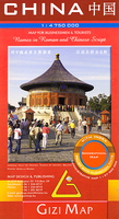
A general map of the country showing main roads, railways, rivers, lakes & towns. Vivid hill shading shows the general relief, with additional spot heights for significant peaks. Some intermediate driving distances are indicated on the map and the Great Wall is clearly marked.Other symbols show airports and some places of interest. The map has quite a crowded apearance, but province boundaries are also included if you look hard enough. The north-eastern extremity of the country and the island of Hainan are shown in insets.Latitude and longitude lines are drawn at 4º intervals.There is a small street plan of central Beijing showing rail and metro stations and highlighting landmarks and important buildings.The legend includes English, there is a road distance chart and an index for
locations. Text on the reverse covers the country`s general geography, climate, history and culture. A selection of places of interest are also briefly described.
locations. Text on the reverse covers the country`s general geography, climate, history and culture. A selection of places of interest are also briefly described.

Product Description
Reviews/Comments
Add New
Intelligent Comparison
Archived Product
China Stanfords
£9.95
Archived Product

China Stanfords
£9.50
Archived Product
China Stanfords
£9.99
Archived Product
China Stanfords
£5.99
Archived Product
China Stanfords
£15.99
Archived Product
China Stanfords
£15.19
Archived Product
China Stanfords
£18.99
Archived Product
China Stanfords
£7.99
Vouchers
No voucher codes found.
Do you know a voucher code for this product or supplier? Add it to Insights for others to use.
Do you know a voucher code for this product or supplier? Add it to Insights for others to use.
 Denmark