
 United Kingdom
 France
 Germany
 Netherlands
 Sweden
 USA
USA
 Italy
Italy
 Spain
Spain
More From Contributor


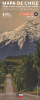
Chile
Chile on a waterproof and tear-resistant map at 1:1, 300, 000 from the locally-based Compass Editorial publishers, presenting the country on five panels. Road network is classified into five types: expressways, main, secondary and dirt roads; driving distances are shown on main and selected secondary routes, plus locations of petrol stations, tolls and borders crossings. Names of larger towns are prominently highlighted, making the map useful for long-distance route planning. Symbols indicate various places of interest. Topography, particularly in the northern and central regions of the country, is shown by bold altitude colouring, much less prominent in the southern regions, with plenty of peak names and heights. National parks and other protected areas are marked. The panels
have no geographical coordinates; some include a list of main towns. Map legend includes English.Also provided is a distance table.
have no geographical coordinates; some include a list of main towns. Map legend includes English.Also provided is a distance table.

Product Description
Reviews/Comments
Add New
Vouchers
No voucher codes found.
Do you know a voucher code for this product or supplier? Add it to Insights for others to use.
Do you know a voucher code for this product or supplier? Add it to Insights for others to use.
 Denmark