
 United Kingdom
 France
 Germany
 Netherlands
 Sweden
 USA
USA
 Italy
Italy
 Spain
Spain
More From Contributor


Chile
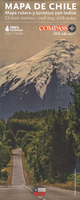
Indexed, double-sided waterproof map of Chile covering part of Southern Patagonia and Tierra Del Fuego, all at 1:1, 300, 000 scale.The map shows the road and rail networks, international and local airports, including landing strips. Selected campsites and places of interest are indicated, including active volcanoes; national boundaries are shown with names of the countries clearly marked.National parks are marked whilst relief is shown by altitude colouring and spot heights. The map has an index of localities and a latitude/longitude grid drawn at intervals of 1
Product Description
Reviews/Comments
Add New
Intelligent Comparison
Archived Product
Chile Stanfords
£9.95
Archived Product

Chile Stanfords
£9.50
Archived Product
Chile Stanfords
£10.95
Archived Product
Chile Stanfords
£9.95
Archived Product
Chile Stanfords
£15.99
Archived Product
Chile Stanfords
£15.99
Archived Product
Chile Stanfords
£16.99
Archived Product

Chiloe Stanfords
£16.99
Vouchers
No voucher codes found.
Do you know a voucher code for this product or supplier? Add it to Insights for others to use.
Do you know a voucher code for this product or supplier? Add it to Insights for others to use.
 Denmark