
 United Kingdom
 France
 Germany
 Netherlands
 Sweden
 USA
USA
 Italy
Italy
 Spain
Spain
More From Contributor

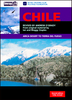


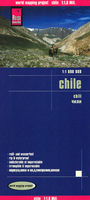
Chile Reise Know-How
Chile at 1:1, 600, 000 on an indexed, waterproof and tear-resistant road map with topographic and tourist information, published by Reise Know-How as part of their highly acclaimed World Mapping Project. The map is double-sided to provide the best balance between a good scale and a convenient size sheet and presents this unusually long country in four sections. The two central panels also give good coverage of the Argentinian Andes, whilst the southern panel (southwards from approx. 46º, including the Chile Chico / Los Antiguos border crossing) extends to all the way to the Atlantic to cover southern Patagonia with Tierra del Fuego.Topography is shown by altitude colouring with graphics for salt flats, glaciers and names of mountain ranges, peaks, etc. National parks and other
protected areas are highlighted. Road network distinguishes between paved and unsurfaced roads and includes selected tracks. Driving distances are shown on main and selected secondary roads and border crossings are marked. Railway lines are included, local airports are indicated and in the fjords south of Puerto Montt ferry routes are marked. Internal administrative boundaries are shown with names of the provinces.The map highlights towns, villages and natural features worth visiting. Symbols show various places of interest, including campsites and selected mountain shelters, beaches and surfing sites, skiing and fishing areas, archaeological remains, thermal spas, etc. The map has a grid with latitude and longitude at intervals of 1º and an extensive index of localities with a
separate list of national parks and protected areas. Map legend includes English.

Product Description
Reviews/Comments
Add New
Vouchers
No voucher codes found.
Do you know a voucher code for this product or supplier? Add it to Insights for others to use.
Do you know a voucher code for this product or supplier? Add it to Insights for others to use.
 Denmark