More From Contributor
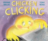
£8.99
Chichester, South Harting & Selsey area of Sussex & Hampshire on a detailed topographic & GPS compatible map OL8, paper version, from the Ordnance Survey’s 1:25, 000 Explorer series. Coverage along the coast extends from Pagham westwards across Selsey Bill & Hayling Island to Langstone Harbour, &

Includes::
part of the South Downs National Park, Emsworth, Havant, Horndean, a section of the South Downs Way National Trail, the Sussex Border Path, the West Sussex Literary Walk, the Monarch’s Way, etc.MOBILE DOWNLOADS: this title & all the other OS Explorer maps include a code for downloading after purchase the digital version onto your smartphone or tablet for viewing on the OS smartphone app.OS EXPLORER SERIES: to see the list of all the titles in the OS Explorer series, both paper & waterproof versions, please click on the series link. The Explorer series, Ordnance Survey’s most detailed maps recommended for anyone enjoying outdoor activities, provides topographic coverage of Great Britain at 1:25, 000 on GPS compatible maps with hiking trails, cycling routes & extensive tourist information. Each printed map is available either on paper or as a waterproof & tear-resistant OS Active Map, as indicated in its title. Britain’s National Parks & other areas of particular tourist interest are presented on often double-sided OL (Outdoor Leisure) maps, whilst most standard format Explorers cover an area of 30 x 20km (approx. 19 x 12 miles). All three versions (paper, waterproof & digital) are the same & provide plenty of recreational & tourist information, indicating the traditional public right of way paths (except in Scotland where different laws apply), including bridleways & byways. National Trails & other long-distance paths are marked, as well as permissive footpaths or bridleways & on-road or traffic-free cycle routes with, where appropriate, their National/ Regional Cycle Network numbers. Boundaries of access land are clearly marked. A wide range of symbols provides additional tourist information, highlighting camping & caravanning sites, information offices & visitors’ centres, parking & picnicking places, country pubs, sport & recreational facilities including cycle hire locations & mountain biking trails, historic buildings & museums, etc. Exceptionally clear presentation of the landscape is provided by contours at 5m or in the uplands at 10m intervals, with additional spot heights plus colouring and/or graphics for different types of woodlands, orchards, heath, marshl&, scree or boulders, & other topographic features. For GPS users the maps have British National Grid lines at 1km intervals, with latitude & longitude given by margin ticks at 1`. Clearly laid out map legend

Includes::
French & German translations for the tourist information symbols.


...
Archived Product
£11.19
Laminated waterproof edition of a detailed topographic map from the Ordnance Survey Explorer series, covering South Harting & Selsey (showing part of the South Downs Way). Edition B2 with minor changes; Publication date April 2009 About this series: These highly detailed maps show all the administrative boundaries, settlements as small as isolated farms, the road network down to unfenced roads & country tracks, & field boundaries (hedges & drystone walls) which make navigation across the countryside much easier. Steep gradients on roads are indicated. Various landmarks, e.g. powerlines, archaeological sites, windmills, churches & lighthouses are shown & additional graphics indicate natural terrain features such as cliffs, scree, mud & vegetation variations. The contour interval is 5 metres in the lower parts of the country & 10 metres in the uplands, & spot heights are marked. Each map covers an area of 30 x 20km (i.e. approx. 19 x 12 miles), with some double-sided maps covering more, as indicated in the individual descriptions. The maps are fully GPS compatible, with the National Grid shown at 1km intervals & latitude & longitude indicated by margin ticks at 1'. The Explorer series has replaced the earlier, green-cover Pathfinder maps. The Explorer series is now complete & covers all of Engl&, Wales & Scotl&. Some sheets for popular areas like the National Parks are still branded as Outdoor Leisure (OL) maps, but are now included in this series as the cartography is the same as that in the Explorer Maps. The Explorer maps offer a substantial improvement on the Pathfinder series, with greater use of colour, larger area per map, & stronger emphasis on information for ramblers & tourists. This series is ideal for walking & other outdoor pursuits & each map shows a large amount of information for ramblers & tourists. Public rights of way are shown (except in Scotland), together with other routes with public access: National Trails & Recreational Paths, permitted paths & bridleways, & selected cycle routes. Open access land created under the Countryside & Rights of Way Act 2000 is marked. Tourist information

Includes::
caravan & camp sites, Park & Ride locations, recreation/leisure/sport centres, museums, historic buildings, English Heritage & National Trust sites, rural pubs, etc. The map legend is in English only, except for the tourist information content which is also in French & German.

...
Archived Product
£14.99
Chichester, South Harting & Selsey area of Sussex & Hampshire on a detailed topographic & GPS compatible map OL8, waterproof version, from the Ordnance Survey’s 1:25, 000 Explorer series. Coverage along the coast extends from Pagham westwards across Selsey Bill & Hayling Island to Langstone Harbour, &

Includes::
part of the South Downs National Park, Emsworth, Havant, Horndean, a section of the South Downs Way National Trail, the Sussex Border Path, the West Sussex Literary Walk, the Monarch’s Way, etc.MOBILE DOWNLOADS: this title & all the other OS Explorer maps include a code for downloading after purchase the digital version onto your smartphone or tablet for viewing on the OS smartphone app.OS EXPLORER SERIES: to see the list of all the titles in the OS Explorer series, both paper & waterproof versions, please click on the series link. The Explorer series, Ordnance Survey’s most detailed maps recommended for anyone enjoying outdoor activities, provides topographic coverage of Great Britain at 1:25, 000 on GPS compatible maps with hiking trails, cycling routes & extensive tourist information. Each printed map is available either on paper or as a waterproof & tear-resistant OS Active Map, as indicated in its title. Britain’s National Parks & other areas of particular tourist interest are presented on often double-sided OL (Outdoor Leisure) maps, whilst most standard format Explorers cover an area of 30 x 20km (approx. 19 x 12 miles). All three versions (paper, waterproof & digital) are the same & provide plenty of recreational & tourist information, indicating the traditional public right of way paths (except in Scotland where different laws apply), including bridleways & byways. National Trails & other long-distance paths are marked, as well as permissive footpaths or bridleways & on-road or traffic-free cycle routes with, where appropriate, their National/ Regional Cycle Network numbers. Boundaries of access land are clearly marked. A wide range of symbols provides additional tourist information, highlighting camping & caravanning sites, information offices & visitors’ centres, parking & picnicking places, country pubs, sport & recreational facilities including cycle hire locations & mountain biking trails, historic buildings & museums, etc. Exceptionally clear presentation of the landscape is provided by contours at 5m or in the uplands at 10m intervals, with additional spot heights plus colouring and/or graphics for different types of woodlands, orchards, heath, marshl&, scree or boulders, & other topographic features. For GPS users the maps have British National Grid lines at 1km intervals, with latitude & longitude given by margin ticks at 1`. Clearly laid out map legend

Includes::
French & German translations for the tourist information symbols.


...
Archived Product
£29.95
One of the maps in the topographic survey of Peru from the country’s national survey organization, Instituto Geográfico Nacional. Contours are at 25m intervals & colouring/symbols indicate different types of terrain & vegetation. Some of the maps may contain small blank spaces representing as yet unmapped areas. Each sheet covers 30’ latitude by 30’ longitude. The maps have a 1km UTM grid & margin ticks for latitude & longitude at intervals of 1’. Publication dates vary; most maps were published in 1960s to 1990s, with some sheets revised more recently. Map legend is in Spanish only, except in the more recent editions which also include English. ...
Archived Product
£20.00
Southeast Asian food is fresh, easy & full of unforgettable flavours: Chicken & Rice will show you just how simple it is to make at home. Shu Han Lee moved to London from Singapore as a student. Homesick & hungry, she started teaching herself to cook the food she`d grown up with
- Singaporean & Malaysian dishes, with a strong Chinese influence from her Hokkien Chinese mother. These recipes, from her mother`s sesame oil chicken to ox cheek & venison rendang, are ones you will want to make time & time again. There are perfect midweek suppers rustled up in less time than it takes to order a takeaway, & healthier & better tasting at that: fennel & minced pork stir fry, fried hor fun noodles with kale & beansprouts or tom yum soup with mussels. For weekends, there are more adventurous projects: learn how to make your own steamed buns, egg noodles, or BBQ sambal lemon sole
- a whole fish barbequed on banana leaves. Although these are Southeast Asian recipes, Shu`s seasonal approach to the very best of UK produce is reflected throughout this book: from Brussels sprouts with smashed garlic & oyster sauce to no-churn rhubarb & condensed milk ice cream. There are also recipes that Shu has picked up on her travels throughout Southeast Asia, such as Vietnamese caramel pork ribs, Thai baked glass noodles with prawns & black pepperand Burmese chickpea tofu with fish sauce, lime & honey dressing.

...
Archived Product
£8.99
What would you do if you woke up one night to find the shadow of a giant chicken passing your bedroom door? Go & investigate of course! When Anyaugo follows a giant chicken into her kitchen one warm night in Nigeria, she embarks on a hilarious adventure where nothing is quite as it seems. Is the nature spirit that lives in the wooden walls of her house a help or a hindrance? Is the mischievous giant chicken a friend or a foe? Most importantly, will Anyaugo be able to save the food her aunties have cooked for the New Yam Festival the next day? World Fantasy Award-winning author Nnedi Okorafor provides us with a hugely entertaining look at the fascinating masquerade culture of West Africa, told from the perspective of a plucky young Nigerian girl who finds the courage to protect the traditions she loves. ...
Archived Product
£5.99
This is hilarious, hen-sational new adventure series by the author of bestselling Atticus Claw. Young chicken Amy Cluckbucket dreams of escaping from Perrin`s farm to a life of chicken adventure. One day Amy receives a summons to the Kung Foo School for Poultry in Tibet where she learns she is to become part of an elite chicken squad whose mission is to defeat their evil predators. It sounds like a dream come true for Amy but she`s disappointed to find that fellow squad members, Ruth & Boo, don`t seem to want to make friends. Ruth is too busy inventing things & Boo has problems of her own. The chickens travel to Chicken HQ to meet their mentor, Professor Rooster. When their first mission flops it is Amy who persuades the others that they should stick together to restore Professor Rooster`s faith in them. Through a series of egg-citing adventures & hilarious mishaps the three young chickens learn the value of friendship & teamwork. But will they be ready for their biggest mission so far
- to save the chicks of St Eggbert`s Primary School from the jaws of their mortal enemy, Thadeus E Fox?
...
Archived Product
£6.99
Chicken Nugget is a hilarious new picture book by Michelle Robinson & Tom Mc Laughlin. My name is Nugget. Chicken Nugget. This is my family. I`m the smallest. & when you`re the smallest, nobody ever listens. When Nugget`s long-lost-cousin Franz turns up, all isn`t quite as it seems. There`s definitely something fishy
- or foxy
- about this chicken. This is Nugget`s chance to save the day, because sometimes the bravest hero of all is just a little chicken.

...
Archived Product
£6.95
Topographic coverage of mainland Spain at 1:50, 000 in the MTN50 (Mapa Topográfico Nacional) series from the Centro Nacional de Información Geografica, the country’s civilian survey organization. The maps have contours at 20m intervals, enhanced by relief shading, plus colouring and/or graphics to show different types of terrain, vegetation or land use. Boundaries of national parks & other protected areas are marked. In addition to all the usual information featured on topographic mapping at this scale, detailed presentation of the road & rail networks, rural tracks & paths, etc, the maps also show campsites & mountain refuges. On more recent editions some GRs, the official long-distance hiking routes, are also marked (although not as clearly as on hiking maps from other publishers). Each map covers 29.5x 18.5 km (with adjustments in the border or coastal areas). The maps have a 1-km UTM grid, plus margin ticks for latitude & longitude at 1` intervals. Map legend is in Spanish only.HOW TO CHOOSE THE RIGHT 50K MAP: all the titles in CNIG’s 200K Provincial Road Maps series at 1:200, 000 are overprinted with the grid for the 1:50, 000 maps & can be used to see the area covered by each 50K title. TO SEE THE LIST OF TITLES IN THIS SERIES PLEASE CLICK ON THE SERIES LINK.PLEASE NOTE
- MAP TITLES: the grids shown on our website serve both the civilian & the military 1:50, 000 topographic series. Although the areas covered by maps in both series are identical (apart from some border or coastal sheets), occasionally map titles differ – only one title is shown on the grid, usually the military one. In Galicia, the Basque country & in the Catalan speaking areas the tendency now is to use local place names rather than the often better known Castilian ones. Where possible, both versions are included in our titles. Map titles listed on our website are based on information received by us at the time of publication, but sometimes maps arrive showing a completely different title! As long as the map number is as ordered, the correct map has been supplied.
...
Archived Product
£6.50
Topographic coverage of mainland Spain at 1:25, 000 published by the Centro Nacional de Información Geograficá, the country’s civilian survey organization. The maps have contours at 10m intervals & colouring and/or graphics to show different types of vegetation or land use. Boundaries of national parks & other protected areas are marked. In addition to all the usual information shown on topographic maps at this scale, detailed presentation of the road & rail networks, rural tracks & paths, etc, the maps also show campsites. The maps have a 1-km UTM grid, with margin ticks for latitude & longitude at 1` intervals. Map legend is in Spanish only.PLEASE NOTE: our grid for the whole of Spain is in preparation
- in the meantime, for areas other than those shown on the attached grid please use CNIG’s topographic survey at 1:50, 000 by searching for ‘SI00000832’. Each 25K map covers one quarter of the corresponding 50K map, with the numbering system: I = NW quarter, II = NE quarter, III = SW quarter & IV = SE quarter. CNIG maps in the Provincial Road Maps series at 1:200, 000 are overprinted with the grid for the 1:50, 000 survey & can be used to see the area covered by each 50K or 25K title in more detail. To see the list of titles in this series please click on the series grid
- for map numbers not yet listed on our website please contact us by email.

...
Archived Product

Chicken Clicking

One night Chick hops onto the farmer`s house and has a browse on his computer - click - soon she`s shopping online for the whole farm! But when she arranges to meet up with a friend she`s made online, she discovers all is not as it seems...Little Red Riding Hood for the iPad generation, this is the perfect book for teaching children how to stay safe online.
RIP - This product is no longer available on our network. It was last seen on 25.09.2019

This page now acts as a permanent archive for this product. Add more information using the comments box below to ensure it can still be found by future generations.

Use our search facility to see if it is available from an alternative contributor.
  • Availability: Out Of Stock
  • Supplier: Stanfords
  • SKU: 9781783440528
Availability: In Stock
£11.99

Product Description

One night Chick hops onto the farmer`s house & has a browse on his computer
- click
- soon she`s shopping online for the whole farm! But when she arranges to meet up with a friend she`s made online, she discovers all is not as it seems... Little Red Riding Hood for the iPad generation, this is the perfect book for teaching children how to stay safe online.

Reviews/Comments

Add New

Intelligent Comparison

Oooops!
We couldn't find anything!
Perhaps this product's unique.... Or perhaps we are still looking for comparisons!
Click to bump this page and we'll hurry up.

Price History

Vouchers

No voucher codes found.
Do you know a voucher code for this product or supplier? Add it to Insights for others to use.

Facebook

Jargon Buster

Computer - A programmable electronic machine which stores and manipulates data.
Red - One of the three primary colours
Children - A young life form within the early stages of physical development,

Supplier Information

Stanfords
Stanfords was established in 1853 and opened their iconic Covent Garden flagship store in 1901. They have become the top retailer of maps, travel books and accessories in the UK and arguably offer the largest selection of maps and travel books worldwide. Famous names such as Captain Robert Falcon Scott, Ranulph Fiennes and Michael Palin have purchased from Stanfords. They now have a shop in Bristol and both stores together with other venues operate a calendar of events including talks, book signings and exhibitions. As a specialist map retailer, the map selection is comprehensive and includes road maps, street maps and walking maps from worldwide destinations, as well as a selection of world atlases and wall maps. Books include travel guides and travel literature. Stanfords also stock globes, from miniatures made of blue marble to magnificent floor-standing globes. The website features a selection of interesting articles on travel topics.
Page Updated: 2023-11-12 20:15:36

Community Generated Product Tags

Oh No! The productWIKI community hasn't generated any tags for this product yet!
Menu