More From Contributor

£6.95
Topographic coverage of mainland Spain at 1:50, 000 in the MTN50 (Mapa Topográfico Nacional) series from the Centro Nacional de Información Geografica, the country’s civilian survey organization. The maps have contours at 20m intervals, enhanced by relief shading, plus colouring and/or graphics to show different types of terrain, vegetation or land use. Boundaries of national parks & other protected areas are marked. In addition to all the usual information featured on topographic mapping at this scale, detailed presentation of the road & rail networks, rural tracks & paths, etc, the maps also show campsites & mountain refuges. On more recent editions some GRs, the official long-distance hiking routes, are also marked (although not as clearly as on hiking maps from other publishers). Each map covers 29.5x 18.5 km (with adjustments in the border or coastal areas). The maps have a 1-km UTM grid, plus margin ticks for latitude & longitude at 1` intervals. Map legend is in Spanish only.HOW TO CHOOSE THE RIGHT 50K MAP: all the titles in CNIG’s 200K Provincial Road Maps series at 1:200, 000 are overprinted with the grid for the 1:50, 000 maps & can be used to see the area covered by each 50K title. TO SEE THE LIST OF TITLES IN THIS SERIES PLEASE CLICK ON THE SERIES LINK.PLEASE NOTE
- MAP TITLES: the grids shown on our website serve both the civilian & the military 1:50, 000 topographic series. Although the areas covered by maps in both series are identical (apart from some border or coastal sheets), occasionally map titles differ – only one title is shown on the grid, usually the military one. In Galicia, the Basque country & in the Catalan speaking areas the tendency now is to use local place names rather than the often better known Castilian ones. Where possible, both versions are included in our titles. Map titles listed on our website are based on information received by us at the time of publication, but sometimes maps arrive showing a completely different title! As long as the map number is as ordered, the correct map has been supplied.
...
Archived Product
£245.00
This publication is a comprehensive guide to chemical tanker cargo operations. It is an essential reference point for serving officers & managers, as well as those undertaking advanced training as required by the STCW Convention. Fully illustrated throughout with colour photographs & annotated diagrams, it covers topics such as international regulations, cargo handling & hazards, environmental protection, emergency response, safety management, tank cleaning & ship design & equipment. ...
Archived Product
£12.99
Topographic survey of France at 1:25, 000 in IGN`s excellent TOP25 / Série Bleue series. All the maps are GPS compatible, with a 1km UTM grid plus latitude & longitude lines at 5’ intervals. Contours are at 5m intervals except for mountainous areas where the maps have contours at 10m intervals, vividly enhanced by hill shading & graphics for rocky terrain. Colouring with graphics indicates different types of vegetation or land use (deciduous or coniferous forests, moors, orchards, vineyards, etc). PLEASE NOTE: coverage of France at this scale is currently being revised – the format & the presentation of each title are indicated by the letters at the end of its Sheet Reference number (e.g. 0416ET, 3531ETR, 1923SB, etc.)MAPS WITH FULL TOURIST OVERPRINT & AN ENGLISH MAP LEGEND: all TOP25 maps & the SB editions of Série Bleue have an overprint highlighting waymarked walking trails including long-distance GR routes &, where appropriate, ski routes. Symbols indicate campsites, gîtes d’etape, refuges, equestrian centres & other recreational facilities or sites, tourist information centres, cultural heritage, etc. Towns & locations of particular interest are highlighted.- ET or OT = single-sided TOP25 map covering approx. 29x 21 km / 18x 13 miles.- ETR or OTR = waterproof & tear resistant TOP25 map covering the same area as the corresponding ET or OT number, but double-sided, printed on a smaller size sheet with a good overlap between the sides.- SB = Série Bleue map with full tourist overprint; these maps, first introduced in summer 2014, each cover approx. 29x 24km / 18x 15 miles.SÉRIE BLEUE maps with numbers ending in E (Est) or O (Ouest): most editions now indicate the GR routes, but do not show any other tourist information. Map legend is in French only. Each map covers approx. 14x 20km / 9x 12 miles. ...
Archived Product
£6.99
The main route within France of the Way of St. James, from Le Puy-en-Velay via Conques, Figeac & Condom to St-Jean-Pied-de Port in the Pyrenees, present by Michelin in a pocket-size road atlas with map extracts from their Local Series at 1:150, 000; plus accommodation recommendations & street plans. The route is prominently overprinted on extracts at 1:150, 000, presenting the road network in good detail expected of Michelin’s mapping, also used in the publishers’ Local Series covering the whole of France. Each section is also shown on a route profile indicating locations with recommended accommodation, listed below with their seasonal opening dates & contact details. The atlas is index & also

Includes::
street plans of Le Puy, Figeac, Cahors, Moissac, Condom & St-Jean-Pied-de-Porte indicating main sights, car parks & one-way streets. Map legend

Includes::
English.


...
Archived Product
£15.99
Roussillon Pays Cathare Guide Vert *FRENCH Edition* in Michelin’s Green Guide series covering France, with all the regions available either in English editions or in French versions. Drawing on Michelin’s long experience, the guides are renowned for their individual ‘star rating’ of sights & attractions. Listings in each guide are organized alphabetically, allowing readers to access information quickly. Towns are given overall star rating, with their sights & attractions also rated individually. Where appropriate, a street plan of the town centre is provided, indicating car parks & accompanied by an index of main streets & a list of sights highlighted on it. For many towns a recommended sightseeing tour is also marked on the plan. Entries for important churches are accompanied by detailed plans. Recommended car tours have overview maps showing road numbers & locations of the sights. Where necessary, the guides give opening hours & contact details. Many entries have an “ Address Book” section with Michelin’s recommendations for where to stay & where to eat. Each guide has a very extensive introductory section with practical information & pre-trip tips, chapters on history, art & culture (particularly strong on architectural styles, explained by excellent drawings), fauna & flora, etc. Fold-out flaps in the book covers provide an overview of the recommended sights and/or car tours.* * French language guides* have a larger number of individual entries than included in the corresponding English titles, as well as more exhaustive descriptions, with wider coverage of local history and/or famous people connected with a given location.* * English language guides* have more recommendations for car tours. The “ Address Book” sections often include shopping suggestions. ...
Archived Product
£21.99
Chemins de St. Jacques: Toulouse
- Jaca, FFRP topoguide Ref. No. 6534, covering one of the southern routes of the Way of St.
...
Archived Product
£16.99
Chemins de St. Jacques: Cluny/ Lyon-Le Puy à pied from Chamina presents the route overprinted on IGN’s 1:50, 000 topographic survey with details of accommodation, local services & other tourist information. Each stage is shown on extracts from IGN`s 1:50, 000 topographic survey cross-referenced to the descriptions of the route. Symbols indicate various facilities & services: different types of accommodation, places to eat, etc., as well as churches, monasteries & other places of interest.A separate section lists the locations along the route, *providing phone numbers and/or websites for accommodation*, plus information such as restaurants, shops, access to rail or bus services, etc.* All the text is in French.* The guide is illustrated with numerous colour photos. ...
Archived Product
£7.99
London 2011, Catherine Gehrig, conservator at the Swinburne museum, learns of the unexpected death of her lover of thirteen years. As the mistress of a married man she has to grieve in private. Given a special project away from prying eyes & mad with grief, the usually controlled & rational Catherine discovers a series of handwritten notebooks telling the extrordinary story behind the automata she is restoring. She starts to piece together both the clockwork puzzle & the story of the mechanical creature which was commissioned in 19th century Germany by an English man, Henry Brandling, as a `magical amusement` for his consumptive son. Having been asked to leave his home by his wife, Henry turns his hurtful departure into an adventure that he records for his young child. But it is Catherine Gehrig, in a strangely stormy & overheated London nearly two hundred years later, who will find comfort & wonder in reading Henry`s story. & it is the automata, in its beautiful, uncanny imitation of life, that will link two strangers confronted with the mysteries of life & death, the miracle & catastrophe of human invention & the body`s astonishing chemistry of love & feeling. ...
Archived Product
£5.50
ADAC, Germany's equivalent of the British Automobile Association publishes an extensive series of street plans which provide detailed high-quality mapping of all the major towns & cities, including their outer suburbs. The plans name all the individual streets & indicate all the main landmarks & public buildings. All public transport facilities are shown: buses, trams, underground & overland rail lines. One way streets & car parks are indicated. Plans of larger cities include an enlargement for the city centre. The plans also show the administrative & postal divisions & have an extensive street index which, where appropriate, shows individual postal codes for each street. On the reverse, each plan has a road map at 1:100, 000, covering a very wide area around the city. Map legend

Includes::
English.

...
Archived Product
£19.95
One of the titles in a series of regional street atlases providing detailed mapping of the main urban conurbations in Germany. The plans name all the individual streets & indicate all the main landmarks & public buildings. All public transport facilities are shown: buses, trams, underground & overland rail lines. One way streets & car parks are indicated. Each atlas also

Includes::
enlargements showing town centres at a more detailed scale, a general road map of the area, & diagrams of motorways with exits & service areas. The plans also show the postal divisions & have an extensive street index which, where appropriate, shows individual postal codes for each street. Map legend

Includes::
English. In this atlas: the area around Chemnitz & Zwickau, including Altenburg, Gera, Glauchau, Freiberg, Greiz, Plauen, Bautzen, & Annaberg-Bucholz.


...
Archived Product

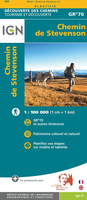
Chemin De Stevenson GR70 IGN 89023

Robert Louis Stevenson’s and his donkey Modestine’s trail from the “Travels with a Donkey in the Cevennes”, now the GR70 long-distance hiking route, presented at 1:100, 000 on a waterproof and tear-resistant map from IGN with cartography from their highly popular TOP100 series. Coverage starts in Le Puy-en-Velay along the GR3/GR43 and continues along the GR70 from Le Monastier-sur-Gazeille across Lagogne, Le Blemeyard, Mont Lozère and Florac to St-Jean-du-Gard, and then westwards along the GR44A to Alès.The route is prominently highlighted on contoured mapping and annotated with hiking distances, “Relais Stevenson” accommodation and locations for hiring a donkey. Symbols across the whole area covered by the map also show refuges, gîtes-d’etape, sport and
recreational facilities, cultural heritages, etc. The map has no geographical coordinates for GPS. Also provided are a route profile and plus notes about the author and the history of the trail, illustrated with colour photos. Map legend and the text include English.To see the list of titles in this new series begun by IGN in spring 2016 please click on the series link.
RIP - This product is no longer available on our network. It was last seen on 25.09.2019

This page now acts as a permanent archive for this product. Add more information using the comments box below to ensure it can still be found by future generations.

Use our search facility to see if it is available from an alternative contributor.
  • Availability: Out Of Stock
  • Supplier: Stanfords
  • SKU: 9782758536352
Availability: In Stock
£9.99

Product Description

Robert Louis Stevenson’s & his donkey Modestine’s trail from the “ Travels with a Donkey in the Cevennes”, now the GR70 long-distance hiking route, presented at 1:100, 000 on a waterproof & tear-resistant map from IGN with cartography from their highly popular TOP100 series. Coverage starts in Le Puy-en-Velay along the GR3/GR43 & continues along the GR70 from Le Monastier-sur-Gazeille across Lagogne, Le Blemeyard, Mont Lozère & Florac to St-Jean-du-Gard, & then westwards along the GR44A to Alès. The route is prominently highlighted on contoured mapping & annotated with hiking distances, “ Relais Stevenson” accommodation & locations for hiring a donkey. Symbols across the whole area covered by the map also show refuges, gîtes-d’etape, sport & recreational facilities, cultural heritages, etc. The map has no geographical coordinates for GPS. Also provided are a route profile & plus notes about the author & the history of the trail, illustrated with colour photos. Map legend & the text include English. To see the list of titles in this new series begun by IGN in spring 2016 please click on the series link.

Reviews/Comments

Add New

Intelligent Comparison

Oooops!
We couldn't find anything!
Perhaps this product's unique.... Or perhaps we are still looking for comparisons!
Click to bump this page and we'll hurry up.

Price History

Vouchers

No voucher codes found.
Do you know a voucher code for this product or supplier? Add it to Insights for others to use.

Facebook

Jargon Buster

GPS - Global Positioning System - Global position using satellites
Hiking - An outdoor activity envolving walking in nature
Waterproof - Resistant to water, usualy specified by depth in metres
History - Anything that happens in the past. An acedemic subject.
Colour - The categorised spectrum of light visable to humans
Resistant - Something that can repel against something.
Accommodation - A room in which someone can live in, for example in a hotel
Popular - Something that is admired and liked by many people.

Supplier Information

Stanfords
Stanfords was established in 1853 and opened their iconic Covent Garden flagship store in 1901. They have become the top retailer of maps, travel books and accessories in the UK and arguably offer the largest selection of maps and travel books worldwide. Famous names such as Captain Robert Falcon Scott, Ranulph Fiennes and Michael Palin have purchased from Stanfords. They now have a shop in Bristol and both stores together with other venues operate a calendar of events including talks, book signings and exhibitions. As a specialist map retailer, the map selection is comprehensive and includes road maps, street maps and walking maps from worldwide destinations, as well as a selection of world atlases and wall maps. Books include travel guides and travel literature. Stanfords also stock globes, from miniatures made of blue marble to magnificent floor-standing globes. The website features a selection of interesting articles on travel topics.
Page Updated: 2023-11-12 20:15:36

Community Generated Product Tags

Oh No! The productWIKI community hasn't generated any tags for this product yet!
Menu