More From Contributor

£14.99
Mastery of the sea has been crucial in European history: the transition from the medieval to the modern world was marked by the emergence of European ships from their home waters out into the Atlantic, Indian & Pacific Oceans. Solving the problem of ocean navigation was an essential prelude to achieving international powers. In their sea-charts the maritime nations left a unique visual record of their response to the challenge of the sea. In succession Spanish, Portuguese, Dutch, French & English mariners used their charts to express their claims to sovereignty of the seas & territories newly revealed by their naval explorers. This revised & updated book traces the history of charts as eloquent witnesses to the discovery of the world beyond Europe, & to man`s evolving knowledge of the oceans. These charts employed a vivid artistic idiom which expressed man`s passionate feeling for the sea: the gilded compasses, the nightmarish sea-creatures, the stately ships, the royal crests
- all these were fused into a unique artistic practice, which flourished for four centuries. Featuring new photography of the British Library`s most important maritime maps, Charting the Oceans is the definitive guide to this majestic art form.
...
Archived Product
£11.50
Topographic survey of France at 1:25, 000 in IGN`s excellent TOP25 / Série Bleue series. All the maps are GPS compatible, with a 1km UTM grid plus latitude & longitude lines at 5’ intervals. Contours are at 5m intervals except for mountainous areas where the maps have contours at 10m intervals, vividly enhanced by hill shading & graphics for rocky terrain. Colouring with graphics indicates different types of vegetation or land use (deciduous or coniferous forests, moors, orchards, vineyards, etc). PLEASE NOTE: coverage of France at this scale is currently being revised – the format & the presentation of each title are indicated by the letters at the end of its Sheet Reference number (e.g. 0416ET, 3531ETR, 1923SB, etc.)MAPS WITH FULL TOURIST OVERPRINT & AN ENGLISH MAP LEGEND: all TOP25 maps & the SB editions of Série Bleue have an overprint highlighting waymarked walking trails including long-distance GR routes &, where appropriate, ski routes. Symbols indicate campsites, gîtes d’etape, refuges, equestrian centres & other recreational facilities or sites, tourist information centres, cultural heritage, etc. Towns & locations of particular interest are highlighted.- ET or OT = single-sided TOP25 map covering approx. 29x 21 km / 18x 13 miles.- ETR or OTR = waterproof & tear resistant TOP25 map covering the same area as the corresponding ET or OT number, but double-sided, printed on a smaller size sheet with a good overlap between the sides.- SB = Série Bleue map with full tourist overprint; these maps, first introduced in summer 2014, each cover approx. 29x 24km / 18x 15 miles.SÉRIE BLEUE maps with numbers ending in E (Est) or O (Ouest): most editions now indicate the GR routes, but do not show any other tourist information. Map legend is in French only. Each map covers approx. 14x 20km / 9x 12 miles. ...
Archived Product
£6.99
Street plan of Chartres, with en enlargement for the town centre, part of an extensive series covering French cities & towns from Blay-Foldex, the country’s largest, oldest & most experienced publisher of urban mapping. Blay plans include outer suburbs &, where appropriate, adjoining localities forming part of the urban agglomeration & provide brief descriptions of the town’s main sights, contact details for hotels & other places of interest, etc. The plans show one way streets, car parks & pedestrian zones. Important public buildings are clearly marked & identified. Blay street maps are usually double-sided & include an enlargement for the town centre & a street index with separate lists of “edifices publics”: main public buildings, places of worship, schools, sport facilities, stations, etc. Each of the outer suburbs or the adjoining localities, identified with its postcode, has a separate index. Many titles also provide a road map of the environs. All the text is in French only.PLEASE NOTE: to see the list of Blay-Foldex street plans of French towns & cities please click on the series link – the series description also

Includes::
a comparison between Blay & IGN street plans.

...
Archived Product
£12.99
Topographic survey of France at 1:25, 000 in IGN`s excellent TOP25 / Série Bleue series. All the maps are GPS compatible, with a 1km UTM grid plus latitude & longitude lines at 5’ intervals. Contours are at 5m intervals except for mountainous areas where the maps have contours at 10m intervals, vividly enhanced by hill shading & graphics for rocky terrain. Colouring with graphics indicates different types of vegetation or land use (deciduous or coniferous forests, moors, orchards, vineyards, etc). PLEASE NOTE: coverage of France at this scale is currently being revised – the format & the presentation of each title are indicated by the letters at the end of its Sheet Reference number (e.g. 0416ET, 3531ETR, 1923SB, etc.)MAPS WITH FULL TOURIST OVERPRINT & AN ENGLISH MAP LEGEND: all TOP25 maps & the SB editions of Série Bleue have an overprint highlighting waymarked walking trails including long-distance GR routes &, where appropriate, ski routes. Symbols indicate campsites, gîtes d’etape, refuges, equestrian centres & other recreational facilities or sites, tourist information centres, cultural heritage, etc. Towns & locations of particular interest are highlighted.- ET or OT = single-sided TOP25 map covering approx. 29x 21 km / 18x 13 miles.- ETR or OTR = waterproof & tear resistant TOP25 map covering the same area as the corresponding ET or OT number, but double-sided, printed on a smaller size sheet with a good overlap between the sides.- SB = Série Bleue map with full tourist overprint; these maps, first introduced in summer 2014, each cover approx. 29x 24km / 18x 15 miles.SÉRIE BLEUE maps with numbers ending in E (Est) or O (Ouest): most editions now indicate the GR routes, but do not show any other tourist information. Map legend is in French only. Each map covers approx. 14x 20km / 9x 12 miles. ...
Archived Product
£10.95
Chartreuse
- Belledonne area in a series of GPS compatible, contoured TOP75 maps at 1:75, 000 from the IGN, highlighting GR
...
Archived Product
£26.00
Canadian Hydrographic Service charts covering Hudson Bay, Baffin Island including Ungava Bay & Gulf of Boothia. This series


...
Archived Product
£30.00
Charts of War: the Map & Charts That Have Informed & Illustrated War at Sea written by John Blake & published by Conway presents a fascinating selection of maps, charts & maritime plans taken from a wide range of international archives. From the ships of small expeditionary fleets which carried navigational charts to the requirements of modern ships involved in combined operations, John Blake has produced a fascinating account of the role that charts have played in planning, preventing, conducting & recording war at sea. The selection

Includes::
not only maps depicting major battles & amphibious operations, but also those drawn up for tactical & espionage purposes, for coastal defence & the positioning of forts along rivers & at the entrance to harbours, etc. Often less well represented in books on cartography or historical mapping, the examples reproduced here range from the earliest maps & charts, through the Age of Discoveries & the colonial expansion to the two World Wars, the Falklands War & the first Gulf War. Two chapters, Birth of a Nation & Brother Against Brother look at the maps & charts from the American War of Independence & the Civil War. European conflicts of the Napoleonic War are also very well represented. Chapters run in chronological order, organized according to the overall political scene. Informative captions accompany each chart, setting it in a historical context.

...
Archived Product
£16.99
Early Europeans may have believed the world was flat, but by the Middle Ages there was widespread acceptance that it was, in fact, a globe. What remained a mystery, however, was what lay on the ”other side”. The belief in a vast southern continent went back centuries, & many expeditions set out to find it, sometimes in search of wealth, sometimes to convert its inhabitants to Christianity. This is the story of the voyages into this great unknown, by the Chinese & early Americans, the Dutch, Spanish, French & English; it recounts the exploits of pirates & scientists, & what lead to the debunking of many myths, from the sunken Great Southern Continent, to the idea that in the ”antipodes”, people walked upside down. ...
Archived Product
£16.99
Illustrated with photographs from the private family album, this book follows in the footsteps of some of Sir Winston Churchill`s famous trips to the four corners of the world, by his granddaughter Celia Sandys. She visits South Africa, Morocco, France, the USA amongst others
- & recounts how Sir Winston`s trips not only changed the course of world history, but helped to shape the man who has come to be known as `our Greatest Briton`.
...
Archived Product
£7.99
Two childhood friends from small-town Wales meet in Miami for a summer road trip they`ve always dreamed of: to chase the swell of Hurricane Dean all the way up the US East Coast in search of once-in-a-lifetime surf. They embark on a hilarious journey of self-discovery & a travel experience like no other. Mixing the humour of Sideways with the extreme conditions of The Perfect Storm, this new book by one of the UK`s favourite new travel/surfing writers is a quirky travelogue destined to become a cult classic. ...
Archived Product

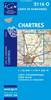
Chartreuse - Belledonne IGN 75002

Chartreuse – Belledonne region in a series of GPS compatible, contoured TOP 75 maps at 1:75, 000 from the IGN, highlighting local and long-distance hiking paths, cycling routes and sites for other recreational activities. The map includes five large panels showing the areas around Pointe de la Gorgeat, Lacs des Sept Laux, Grand Pic de Belledonne, Grand Som, and Dent de Crolles on IGN’s topographic mapping at 1:25, 000 with extensive overprint for local hiking paths and tourist facilities including campsites.Cartography of the main map at 1:75, 000 is a direct enlargement of the mapping used in the IGN’s TOP100 series. Contours are at 40m intervals, enhanced by relief shading; additional colouring shows different types of vegetation (woods, brushwood, vineyards/orchards).
Boundaries of national parks and other protected areas are marked. An overprint highlights long-distance GR hiking routes and cycling trails. Symbols - more numerous than on the TOP100 maps - indicate various places of interest including mountain refuges and gîtes d’etape (campsites on the enlargements), areas for other recreational pursuits such as climbing, hand gliding or water and winter sports, historic or cultural sites, etc. The map has a UTM grid and an index of communes. Map legend includes English.Coverage of the main map extends from Chambery and the A43 motorway in the north to Grenoble in the south.To see the list of other maps in this series please click on the series link.
RIP - This product is no longer available on our network. It was last seen on 25.09.2019

This page now acts as a permanent archive for this product. Add more information using the comments box below to ensure it can still be found by future generations.

Use our search facility to see if it is available from an alternative contributor.
  • External links may include paid for promotion
  • Availability: Out Of Stock
  • Supplier: Stanfords
  • SKU: 9782758532668
Availability: In Stock
£10.99

Product Description

Chartreuse – Belledonne region in a series of GPS compatible, contoured TOP 75 maps at 1:75, 000 from the IGN, highlighting local & long-distance hiking paths, cycling routes & sites for other recreational activities. The map

Includes::
five large panels showing the areas around Pointe de la Gorgeat, Lacs des Sept Laux, Grand Pic de Belledonne, Grand Som, & Dent de Crolles on IGN’s topographic mapping at 1:25, 000 with extensive overprint for local hiking paths & tourist facilities including campsites. Cartography of the main map at 1:75, 000 is a direct enlargement of the mapping used in the IGN’s TOP100 series. Contours are at 40m intervals, enhanced by relief shading; additional colouring shows different types of vegetation (woods, brushwood, vineyards/orchards). Boundaries of national parks & other protected areas are marked. An overprint highlights long-distance GR hiking routes & cycling trails. Symbols
- more numerous than on the TOP100 maps
- indicate various places of interest including mountain refuges & gîtes d’etape (campsites on the enlargements), areas for other recreational pursuits such as climbing, hand gliding or water & winter sports, historic or cultural sites, etc. The map has a UTM grid & an index of communes. Map legend

Includes::
English. Coverage of the main map extends from Chambery & the A43 motorway in the north to Grenoble in the south. To see the list of other maps in this series please click on the series link.

Reviews/Comments

Add New

Intelligent Comparison

Oooops!
We couldn't find anything!
Perhaps this product's unique.... Or perhaps we are still looking for comparisons!
Click to bump this page and we'll hurry up.

Price History

Vouchers

No voucher codes found.
Do you know a voucher code for this product or supplier? Add it to Insights for others to use.

Facebook

Jargon Buster

GPS - Global Positioning System - Global position using satellites
Hiking - An outdoor activity envolving walking in nature
Hand - A part of the body at the end of the arm
Hand - A pointer which indicates time on a clock face
water - A chemical substance. Chemical formula H2O.
Large - something that takes up more space than normal.
Winter - The fourth season of a year that comes between Spring and Autumn

Supplier Information

Stanfords
Stanfords was established in 1853 and opened their iconic Covent Garden flagship store in 1901. They have become the top retailer of maps, travel books and accessories in the UK and arguably offer the largest selection of maps and travel books worldwide. Famous names such as Captain Robert Falcon Scott, Ranulph Fiennes and Michael Palin have purchased from Stanfords. They now have a shop in Bristol and both stores together with other venues operate a calendar of events including talks, book signings and exhibitions. As a specialist map retailer, the map selection is comprehensive and includes road maps, street maps and walking maps from worldwide destinations, as well as a selection of world atlases and wall maps. Books include travel guides and travel literature. Stanfords also stock globes, from miniatures made of blue marble to magnificent floor-standing globes. The website features a selection of interesting articles on travel topics.
Page Updated: 2023-11-12 20:15:36

Community Generated Product Tags

Oh No! The productWIKI community hasn't generated any tags for this product yet!
Menu