More From Contributor
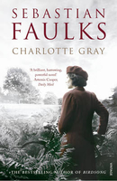
£12.99
Using his own photographs to illustrate the text, Charlie Waite explains the basis of his success as a landscape photographer. From the choice of camera & lens to the subtleties of lighting & composition, from manipulating the image to extracting the essential elements of a scene, he brings his years of practical experience to bear on the subject. The book contains many practical tips for the budding landscape photographer, but technical mastery is only one part of the story. The author aims, above all, to instil in readers his own love of landscape, & to encourage them to respond to, & capture, the world around them. Charlie Waite's prize-winning books include Landscape in Britain, Landscape in France & Landscape in Italy. ...
Archived Product
£9.99
For the first time, Bonnie Prince Charlie`s arduous escape of 1746 has been recreated in a single journey. The author, along with his faithful border collie Meg, retraces the Prince`s epic 530 mile walk through remote wilderness, hidden glens, modern day roads & uninhabited islands. Gregor Ewing tells the Prince`s story alongside the trials of his own present day journey, whilst reflecting on the plight of the highlanders who, despite everything, loyally protected their rightful prince. The author`s love of history & the landscape in which he travels shines through in this modern day adventure. ...
Archived Product
£12.99
Topographic survey of France at 1:25, 000 in IGN`s excellent TOP25 / Série Bleue series. All the maps are GPS compatible, with a 1km UTM grid plus latitude & longitude lines at 5’ intervals. Contours are at 5m intervals except for mountainous areas where the maps have contours at 10m intervals, vividly enhanced by hill shading & graphics for rocky terrain. Colouring with graphics indicates different types of vegetation or land use (deciduous or coniferous forests, moors, orchards, vineyards, etc). PLEASE NOTE: coverage of France at this scale is currently being revised – the format & the presentation of each title are indicated by the letters at the end of its Sheet Reference number (e.g. 0416ET, 3531ETR, 1923SB, etc.)MAPS WITH FULL TOURIST OVERPRINT & AN ENGLISH MAP LEGEND: all TOP25 maps & the SB editions of Série Bleue have an overprint highlighting waymarked walking trails including long-distance GR routes &, where appropriate, ski routes. Symbols indicate campsites, gîtes d’etape, refuges, equestrian centres & other recreational facilities or sites, tourist information centres, cultural heritage, etc. Towns & locations of particular interest are highlighted.- ET or OT = single-sided TOP25 map covering approx. 29x 21 km / 18x 13 miles.- ETR or OTR = waterproof & tear resistant TOP25 map covering the same area as the corresponding ET or OT number, but double-sided, printed on a smaller size sheet with a good overlap between the sides.- SB = Série Bleue map with full tourist overprint; these maps, first introduced in summer 2014, each cover approx. 29x 24km / 18x 15 miles.SÉRIE BLEUE maps with numbers ending in E (Est) or O (Ouest): most editions now indicate the GR routes, but do not show any other tourist information. Map legend is in French only. Each map covers approx. 14x 20km / 9x 12 miles. ...
Archived Product
£12.99
Charlotte Salomon is born into a family stricken by suicide & a country at war
- but there is something exceptional about her.
...
Archived Product
£19.99
Write as if from the desk of Charlotte Brontë with this deluxe note card set, housed in a finely crafted keepsake book box. Charlotte Brontë is the celebrated author of the classic novel Jane Eyre, whose independent & courageous heroine has been enchanting audiences for over 150 years. Now readers can celebrate their love of Charlotte Brontë with this finely crafted deluxe note card set. Designed for the letter-writers, note-takers, & card-senders of the world, this set
Includes::- 20 blank note cards featuring classic Brontë"es- 20 envelopes- 20 embossed gold sticker seals- A ruled pocket journal- A keepsake box for storage Designed to look like one of her classic novels, this collectible set gives Brontë fans a unique way to celebrate the words & legacy of their favorite writer.
...
Archived Product
£7.99
Charlotte & Vicinity in North Carolina in a series of Rand Mc Nally’s regional maps covering the environs of main US cities. The map covers an area centered on the city, extending west beyond Gaffney & Morganton; north beyond Hickory & Statesville to Sawmills & Lenoir; east to Lexington & Richfield; & south to Union, Chester & Lancaster. Other communities include Concord, Gastonia, Kings Mountain, Mineral Springs, Morganton, Rock Hill & Salisbury. Maps in this series present the road network on a clear background with no relief shading to show the area’s topography, but with national or state parks, forests & other protected areas indicated by colouring. Roads are numbered and/or named, showing toll highways, exit numbers of interchanges, services & rest areas. Local airports are marked, but railways & other urban transport lines are not included unless specifically indicated in the individual description. Each town is presented in a different colour, providing those unfamiliar with the region a very clear picture of the area. Various places of interest & facilities are highlighted, including cultural & historical sites, educational institutions, sport & recreational facilities, etc. Each title is indexed. Several maps also include enlargements of the downtown area, plans of international airports, a mileage & driving times diagram for a much wider region than covered by the main map, etc
- for more information please see the individual descriptions. To see all the titles in this series please click on the series link.
...
Archived Product
£7.99
My name is Jason
- & I have just met the most incredible woman, on Charlotte Street. Well, I say `met`. I sort of held her bags
...
Archived Product
£16.99
Topographic survey of Sweden at 1:50, 000, the Terrängkartan, from the Lantmäteriet, covering most of the country in 244 double-sided maps. Please note: the mountainous regions of central & northern Sweden are not covered by this series but presented in a separate “ Fjällkartan
- Mountain Map” series also listed on our website. Each 1:50, 000 topographic survey map covers an area of 37.5 x 40km. The maps have contours at 5 metre intervals, plus relief shading & graphics for rocky outcrops & boulders. Further graphics and/or colouring show different types of land use or vegetation (forests, arable l&, orchards, marshes, peat bogs, etc). An unusual feature of this survey is the colouring indicating buildings below or above two storeys high & “leisure/holiday homes”. The maps indicate privately maintained roads & include all other information expected of topographic survey at this scale. The maps have a 1-km UTM grid, plus latitude & longitude lines 5’ intervals. Map legend

Includes::
English. For coverage of the country’s most visited hiking areas in central & northern Sweden please see Lantmäteriet’s Mountain Map series, listed separately on our website.


...
Archived Product
£13.99
This map of Charlottenberg Arvika in 1:50, 000 is part of a series of topographic maps from Norstedts Kartforlaget which


...
Archived Product
£16.99
Sverigeserien is an outdoor map series consisting of 116 sheets with coverage of southern & central Sweden & the northern coastline. The map is suitable for outdoor activities such as hiking, excursions, trail running, hunting, fishing, riding, cycling, mountain biking, paddling, skating & much more. Every sheet covers an area of 45x 68km. These topographical maps in scale 1:50 000 contain all the information needed for outdoor activities: Terrain information, hiking trails, illuminated tracks, camping, shelters, golf courses, leisure baths, historical remains, roads in different categories, railway lines & much more. Easy to read topography with contour lines, vertical interval 5 m. Sverigeserien is a high-quality map series & is durable for frequent use! Updated content with map data from Lantmäteriet (National Land Survey of Sweden) & printed on Polyart which is water & tear resistant. This means that the map can be folded repeatedly without breaking & can withstand the challenging weather in Sweden during both winter & summer. Legend is in Swedish, English & German. ...
Archived Product

Charlotte Gray

In 1942, Charlotte Gray, a young scottish woman, goes to Occupied France on a dual mission - officially, to run an apparently simple errand for a British special operations group and unofficially, to search for her lover, an English airman who has gone missing in action. In the small town of Lavaurette, Sebastian Faulks presents a microcosm of France and its agony in `the black years`. Here is the full range of collaboration, from the tacit to the enthusiastic, as well as examples of extraordinary courage and altruism. Through the local resistance chief Julien, Charlotte meets his father, a Jewish painter whose inspiration has failed him. In a series of shocking narrative climaxes in which the full extent of French collusion in the Nazi holocaust is delineated, Faulks brings
the story to a resolution of redemptive love. In the delicacy of its writing, the intimacy of its characterisation and its powerful narrative scenes of harrowing public events, Charlotte Gray is a worthy successor to Birdsong.
RIP - This product is no longer available on our network. It was last seen on 25.09.2019

This page now acts as a permanent archive for this product. Add more information using the comments box below to ensure it can still be found by future generations.

Use our search facility to see if it is available from an alternative contributor.
  • External links may include paid for promotion
  • Availability: Out Of Stock
  • Supplier: Stanfords
  • SKU: 9780099394310
Availability: In Stock
£8.99

Product Description

In 1942, Charlotte Gray, a young scottish woman, goes to Occupied France on a dual mission
- officially, to run an apparently simple errand for a British special operations group & unofficially, to search for her lover, an English airman who has gone missing in action. In the small town of Lavaurette, Sebastian Faulks presents a microcosm of France & its agony in `the black years`. Here is the full range of collaboration, from the tacit to the enthusiastic, as well as examples of extraordinary courage & altruism. Through the local resistance chief Julien, Charlotte meets his father, a Jewish painter whose inspiration has failed him. In a series of shocking narrative climaxes in which the full extent of French collusion in the Nazi holocaust is delineated, Faulks brings the story to a resolution of redemptive love. In the delicacy of its writing, the intimacy of its characterisation & its powerful narrative scenes of harrowing public events, Charlotte Gray is a worthy successor to Birdsong.

Reviews/Comments

Add New

Intelligent Comparison

Oooops!
We couldn't find anything!
Perhaps this product's unique.... Or perhaps we are still looking for comparisons!
Click to bump this page and we'll hurry up.

Price History

Vouchers

No voucher codes found.
Do you know a voucher code for this product or supplier? Add it to Insights for others to use.

Facebook

Jargon Buster

Black - A colour which does not emit any colour of the spectrum. Black absorbs all frequencies of the spectrum.
Resolution - The number of pixels a device can display
France - A state situated in Western Europe with several overseas territories.
Love - Someone who shows deep affection for someone else.
Small - something that takes up less space than normal.
Simple - Basic, easy no difficulty in understanding.
Collaboration - To work alongside someone to create something.

Supplier Information

Stanfords
Stanfords was established in 1853 and opened their iconic Covent Garden flagship store in 1901. They have become the top retailer of maps, travel books and accessories in the UK and arguably offer the largest selection of maps and travel books worldwide. Famous names such as Captain Robert Falcon Scott, Ranulph Fiennes and Michael Palin have purchased from Stanfords. They now have a shop in Bristol and both stores together with other venues operate a calendar of events including talks, book signings and exhibitions. As a specialist map retailer, the map selection is comprehensive and includes road maps, street maps and walking maps from worldwide destinations, as well as a selection of world atlases and wall maps. Books include travel guides and travel literature. Stanfords also stock globes, from miniatures made of blue marble to magnificent floor-standing globes. The website features a selection of interesting articles on travel topics.
Page Updated: 2023-11-12 20:15:36

Community Generated Product Tags

Oh No! The productWIKI community hasn't generated any tags for this product yet!
Menu