More From Contributor

£6.95
Topographic coverage of mainland Spain at 1:50, 000 in the MTN50 (Mapa Topográfico Nacional) series from the Centro Nacional de Información Geografica, the country’s civilian survey organization. The maps have contours at 20m intervals, enhanced by relief shading, plus colouring and/or graphics to show different types of terrain, vegetation or land use. Boundaries of national parks & other protected areas are marked. In addition to all the usual information featured on topographic mapping at this scale, detailed presentation of the road & rail networks, rural tracks & paths, etc, the maps also show campsites & mountain refuges. On more recent editions some GRs, the official long-distance hiking routes, are also marked (although not as clearly as on hiking maps from other publishers). Each map covers 29.5x 18.5 km (with adjustments in the border or coastal areas). The maps have a 1-km UTM grid, plus margin ticks for latitude & longitude at 1` intervals. Map legend is in Spanish only.HOW TO CHOOSE THE RIGHT 50K MAP: all the titles in CNIG’s 200K Provincial Road Maps series at 1:200, 000 are overprinted with the grid for the 1:50, 000 maps & can be used to see the area covered by each 50K title. TO SEE THE LIST OF TITLES IN THIS SERIES PLEASE CLICK ON THE SERIES LINK.PLEASE NOTE
- MAP TITLES: the grids shown on our website serve both the civilian & the military 1:50, 000 topographic series. Although the areas covered by maps in both series are identical (apart from some border or coastal sheets), occasionally map titles differ – only one title is shown on the grid, usually the military one. In Galicia, the Basque country & in the Catalan speaking areas the tendency now is to use local place names rather than the often better known Castilian ones. Where possible, both versions are included in our titles. Map titles listed on our website are based on information received by us at the time of publication, but sometimes maps arrive showing a completely different title! As long as the map number is as ordered, the correct map has been supplied.
...
Archived Product
£12.00
” His yearning for Venice, the city of his birth, grew so intense that, like a wounded bird slowly circling downwards in its death flight, he began to move in ever-narrowing circles.” One of Schnitzler`s most poignant evocations of the passing of time & the ironies of sentiment & love, Casanova`s Return to Venice tells the story of an ageing Casanova`s desperate desire to return to the city he truly loves after a life of exile; a desire which is contrasted with his still-libidinous & sensuous
- yet weary
- pursuit of women, money & prestige.

...
Archived Product
£6.50
Topographic coverage of mainland Spain at 1:25, 000 published by the Centro Nacional de Información Geograficá, the country’s civilian survey organization. The maps have contours at 10m intervals & colouring and/or graphics to show different types of vegetation or land use. Boundaries of national parks & other protected areas are marked. In addition to all the usual information shown on topographic maps at this scale, detailed presentation of the road & rail networks, rural tracks & paths, etc, the maps also show campsites. The maps have a 1-km UTM grid, with margin ticks for latitude & longitude at 1` intervals. Map legend is in Spanish only.PLEASE NOTE: our grid for the whole of Spain is in preparation
- in the meantime, for areas other than those shown on the attached grid please use CNIG’s topographic survey at 1:50, 000 by searching for ‘SI00000832’. Each 25K map covers one quarter of the corresponding 50K map, with the numbering system: I = NW quarter, II = NE quarter, III = SW quarter & IV = SE quarter. CNIG maps in the Provincial Road Maps series at 1:200, 000 are overprinted with the grid for the 1:50, 000 survey & can be used to see the area covered by each 50K or 25K title in more detail. To see the list of titles in this series please click on the series grid
- for map numbers not yet listed on our website please contact us by email.

...
Archived Product
£6.95
Topographic coverage of mainland Spain at 1:50, 000 in the MTN50 (Mapa Topográfico Nacional) series from the Centro Nacional de Información Geografica, the country’s civilian survey organization. The maps have contours at 20m intervals, enhanced by relief shading, plus colouring and/or graphics to show different types of terrain, vegetation or land use. Boundaries of national parks & other protected areas are marked. In addition to all the usual information featured on topographic mapping at this scale, detailed presentation of the road & rail networks, rural tracks & paths, etc, the maps also show campsites & mountain refuges. On more recent editions some GRs, the official long-distance hiking routes, are also marked (although not as clearly as on hiking maps from other publishers). Each map covers 29.5x 18.5 km (with adjustments in the border or coastal areas). The maps have a 1-km UTM grid, plus margin ticks for latitude & longitude at 1` intervals. Map legend is in Spanish only.HOW TO CHOOSE THE RIGHT 50K MAP: all the titles in CNIG’s 200K Provincial Road Maps series at 1:200, 000 are overprinted with the grid for the 1:50, 000 maps & can be used to see the area covered by each 50K title. TO SEE THE LIST OF TITLES IN THIS SERIES PLEASE CLICK ON THE SERIES LINK.PLEASE NOTE
- MAP TITLES: the grids shown on our website serve both the civilian & the military 1:50, 000 topographic series. Although the areas covered by maps in both series are identical (apart from some border or coastal sheets), occasionally map titles differ – only one title is shown on the grid, usually the military one. In Galicia, the Basque country & in the Catalan speaking areas the tendency now is to use local place names rather than the often better known Castilian ones. Where possible, both versions are included in our titles. Map titles listed on our website are based on information received by us at the time of publication, but sometimes maps arrive showing a completely different title! As long as the map number is as ordered, the correct map has been supplied.
...
Archived Product
£17.99
Topographic survey of Portugal at 1:50, 000 from the Instituto Geográfico do Exército, the country’s military survey organisation. The maps have contours at 20m intervals & in addition to the standard features shown on topographic mapping at this scale also indicate various types of terrain or vegetation (s&, terraces, rocks, woodlands, vineyards, etc). Each sheet covers an area of 32 x 20km (20 x 12.5 miles approx). The maps have a 1-km UTM grid plus latitude & longitude coordinates for the map corners. Map legend & a glossary of terms used on the maps include English.EDITION DATES: most titles in this series date from 1990s or later. To see all the titles in this series please click on the series link. ...
Archived Product
£17.99
Topographic survey of Portugal at 1:50, 000 from the Instituto Geográfico Português, the country’s civilian survey organisation. The maps have contours at 25m intervals & in addition to the standard features shown on topographic mapping at this scale also indicate various types of vegetation (vineyards, olive groves, etc). Each sheet covers an area of 32 x 20km (20 x 12.5miles approx). The maps have latitude & longitude margin ticks at 1’ intervals & UTM coordinates for the map corners – each sheet also shows conversion details from BBLx (Bessel-Bonnie system, Datum Lisbon) to UTM. Map legend is in Portuguese only.EDITION DATES: most titles in this series have now been updated in the 1990s or later. To see all the titles in this series please click on the series link. ...
Archived Product
£10.99
Keep shirts & other travel essentials tidy with this 2 piece luggage organiser. Constructed from breathable non-woven fabric, these shirt carriers incorporate a quick-view window for instant identification. Garment protection for the serious traveller, they promise to make packing a pleasure. ...
Archived Product
£6.99
` When you have eliminated all which is impossible, then whatever remains, however improbable, must be the truth`. In this, the final collection of Sherlock Holmes adventures, the intrepid detective & his faithful companion Dr Watson examine & solve twelve cases that puzzle clients, baffle the police & provide readers with the thrill of the chase. These mysteries
- involving an illustrious client & a Sussex vampire; the problems of Thor Bridge & of the Lions Mane; a creeping man & the three-gabled house
- all test the bravery of Dr Watson & the brilliant mind of Mr Sherlock Homes, the greatest detective we have ever known.

...
Archived Product
£11.99
Casentino
- Val Tiberina, map no. 35, in a series of walking maps covering the Ligurian Alps & the coast, the crest of the Apennines
...
Archived Product

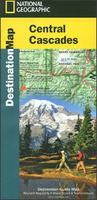
Cascades Destination Map

The Cascades in Washington Stare presented at 1:746, 000 by the National Geographic in their Destination Map series with highlighting for protected areas and tourist notes, plus on the reverse enlargements showing in more detail three most scenic areas: Mount Rainier, Crater Lake and Columbia River Gorge.Printed on light, waterproof and tear-resistant synthetic paper, the map extends along the Cascades from south of Seattle (including the city’s international airport) to the state border. Road numbers are clearly shown. Topography is presented by shading based on the satellite imagery. Various types of protected areas are indicated by the colouring for their borders. Symbols show locations of breweries/pubs, wineries, etc. The map has latitude and longitude lines at 1° intervals
and is surrounded by notes with descriptions of various places of interest, cross-referenced to the map. On the reverse three areas are presented on more detailed maps: Mount Rainier National Park, Crater Lake National Park, and the Columbia River Gorge National Scenic Area, each with a description and tourist tips. Also provided are notes and tables about recreational facilities in the region.To see other titles in this series please click on the series list.
RIP - This product is no longer available on our network. It was last seen on 25.09.2019

This page now acts as a permanent archive for this product. Add more information using the comments box below to ensure it can still be found by future generations.

Use our search facility to see if it is available from an alternative contributor.
  • External links may include paid for promotion
  • Availability: Out Of Stock
  • Supplier: Stanfords
  • SKU: 9781597755122
Availability: In Stock
£9.99

Product Description

The Cascades in Washington Stare presented at 1:746, 000 by the National Geographic in their Destination Map series with highlighting for protected areas & tourist notes, plus on the reverse enlargements showing in more detail three most scenic areas: Mount Rainier, Crater Lake & Columbia River Gorge. Printed on light, waterproof & tear-resistant synthetic paper, the map extends along the Cascades from south of Seattle (including the city’s international airport) to the state border. Road numbers are clearly shown. Topography is presented by shading based on the satellite imagery. Various types of protected areas are indicated by the colouring for their borders. Symbols show locations of breweries/pubs, wineries, etc. The map has latitude & longitude lines at 1° intervals & is surrounded by notes with descriptions of various places of interest, cross-referenced to the map. On the reverse three areas are presented on more detailed maps: Mount Rainier National Park, Crater Lake National Park, & the Columbia River Gorge National Scenic Area, each with a description & tourist tips. Also provided are notes & tables about recreational facilities in the region. To see other titles in this series please click on the series list.

Reviews/Comments

Add New

Intelligent Comparison

Oooops!
We couldn't find anything!
Perhaps this product's unique.... Or perhaps we are still looking for comparisons!
Click to bump this page and we'll hurry up.

Price History

Vouchers

No voucher codes found.
Do you know a voucher code for this product or supplier? Add it to Insights for others to use.

Facebook

Jargon Buster

Paper - A thin sheet mainly used for writing. Available in a variety of colours. Made mainly from wood pulp.
Waterproof - Resistant to water, usualy specified by depth in metres
Road - a manmade lane or a path that is used to speed up travel.
Resistant - Something that can repel against something.
Borders - A line that sometimes can be built up separating off an area, e.g. countries "the welsh boarder"

Supplier Information

Stanfords
Stanfords was established in 1853 and opened their iconic Covent Garden flagship store in 1901. They have become the top retailer of maps, travel books and accessories in the UK and arguably offer the largest selection of maps and travel books worldwide. Famous names such as Captain Robert Falcon Scott, Ranulph Fiennes and Michael Palin have purchased from Stanfords. They now have a shop in Bristol and both stores together with other venues operate a calendar of events including talks, book signings and exhibitions. As a specialist map retailer, the map selection is comprehensive and includes road maps, street maps and walking maps from worldwide destinations, as well as a selection of world atlases and wall maps. Books include travel guides and travel literature. Stanfords also stock globes, from miniatures made of blue marble to magnificent floor-standing globes. The website features a selection of interesting articles on travel topics.
Page Updated: 2023-11-12 20:15:36

Community Generated Product Tags

Oh No! The productWIKI community hasn't generated any tags for this product yet!
Menu