More From Contributor
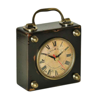
£7.99
From childhood, Jim Corbett, who was born in India in 1875, was at one with the jungles, an expert shikari & an excellent shot, killing his first leopard when he was eight. Tigers were his most sought-after prey but, in time, he began to turn towards conservation. From the mid-1920s, he ceased to shoot tigers for sport: instead he photographed them. He did not stop killing tigers altogether: he still hunted
- but man-eaters. In old age, Corbett became world famous for his stories about his exploits: his best-known book, Man-eaters of Kumaon, told of his adventures against these dangerous, pathetic creatures reduced to killing humans because age or infirmity, often caused by sportsmen's ill-aimed bullets, prevented them from taking their natural prey. In 1936, Corbett was instrumental in the establishment of the first Indian tiger reserve, possibly the world's first big-game 'park'. For the rest of his life, he was dedicated to the preservation of wildlife. This is the story of a hunter-turned conservator & a typical 'domiciled' Englishman in India. It is also a tale of courage, of a deep love for India & her people, & a dedication to natural beauty. To this day, Corbett is revered in northern India as a legendary holy figure who fought the devil in his disguise as a man-eating big cat, & his books on jungle lore & wildlife are also well-respected.
...
Archived Product
£12.99
The Mac Gillycuddy`s Reeks are Ireland`s highest mountains with Carrauntoohil tallest at 1039m. Occupying about 100 square km., they stretch from the picturesque Gap of Dunloe in the east to Glencar in the west. Attracting over 25, 000 walkers annually, they are a wonderful playground. However, many routes are not clearly marked & mist or fog covers them for three quarters of the year. Access to a proper guide is therefore essential before venturing on to the Reeks. This guide to 20 of popular walking routes on the Reeks contains full-colour maps specially commissioned from the Ordnance Survey, clear photographs & precise map references. However, this is not just a walking guide. It also encompasses the history of the area, its geology & natural history, its place names & people. Useful information on travel & accommodation is also provided. It will be the most comprehensive guide to the area to be published for some time. ...
Archived Product
£6.95
Topographic coverage of mainland Spain at 1:50, 000 in the MTN50 (Mapa Topográfico Nacional) series from the Centro Nacional de Información Geografica, the country’s civilian survey organization. The maps have contours at 20m intervals, enhanced by relief shading, plus colouring and/or graphics to show different types of terrain, vegetation or land use. Boundaries of national parks & other protected areas are marked. In addition to all the usual information featured on topographic mapping at this scale, detailed presentation of the road & rail networks, rural tracks & paths, etc, the maps also show campsites & mountain refuges. On more recent editions some GRs, the official long-distance hiking routes, are also marked (although not as clearly as on hiking maps from other publishers). Each map covers 29.5x 18.5 km (with adjustments in the border or coastal areas). The maps have a 1-km UTM grid, plus margin ticks for latitude & longitude at 1` intervals. Map legend is in Spanish only.HOW TO CHOOSE THE RIGHT 50K MAP: all the titles in CNIG’s 200K Provincial Road Maps series at 1:200, 000 are overprinted with the grid for the 1:50, 000 maps & can be used to see the area covered by each 50K title. TO SEE THE LIST OF TITLES IN THIS SERIES PLEASE CLICK ON THE SERIES LINK.PLEASE NOTE
- MAP TITLES: the grids shown on our website serve both the civilian & the military 1:50, 000 topographic series. Although the areas covered by maps in both series are identical (apart from some border or coastal sheets), occasionally map titles differ – only one title is shown on the grid, usually the military one. In Galicia, the Basque country & in the Catalan speaking areas the tendency now is to use local place names rather than the often better known Castilian ones. Where possible, both versions are included in our titles. Map titles listed on our website are based on information received by us at the time of publication, but sometimes maps arrive showing a completely different title! As long as the map number is as ordered, the correct map has been supplied.
...
Archived Product
£16.99
Chiletur Copec
- Chilean Fjords regions of Chile at 1:400, 000 in a series of nine indexed & GPS compatible regional maps from
...
Archived Product
£15.95
Carretera Austral
- Chilean Fjords regions of Chile at 1:400, 000 in a series of nine indexed & GPS compatible regional maps from
...
Archived Product
£10.00
The purpose of this Code was adopted by resolution A.863 (20), is to provide, for both operator & contractor, an international Stardard to avoid or reduce to a minimum the hazzards which affect offshore supply vessels in their daily operation of carrying cargoes & persons from & between offshore installations. This standard should be considered when implementing a safety management system within the meaning of paragraph 1.4 of the International Safety Management (ISM) Code. ...
Archived Product
£6.30
Carrickfergus & Larne on an indexed street plan at 1:10, 000 from the Ordnance Survey of Northern Irel&, plus on the reverse an indexed road map at 1:50, 000 of Carrickfergus & Larne District. OSNI street plans highlight main traffic arteries in each town, indicating motorways, A or B roads, one way or pedestrianized streets & car parks. The plans show Sustrans National Cycle Network with route numbers, tow paths & waymarked walks. Also marked are boundaries of local government districts. Public buildings are highlighted by colour & named. Symbols indicate tourist information offices, bus & or railway stations, public toilets & golf courses. Each plan has Irish national grid lines. On the reverse the plans have an indexed road map of the relevant local government district. ...
Archived Product
£7.99
A SUNDAY TIMES & GUARDIAN BOOK OF THE YEAR, 2017`A Silence of the Lambs for the internet age as a serial killer stalks his prey online, entering & controlling their lives. Chilling & utterly convincing.` Ian Rankin` Exposes a nightmare world of secret surveillance.` Joan Smith, Sunday Times Detectives Carrigan & Miller are thrust into the terrifying world of stalking & obsession when a drugged & distressed young woman arrives at their station claiming her friend has been abducted. Taking them from a backpackers` hostel in west London, to the world of online intimidation, hacking & control, The Intrusionsexplores themes of dark psychology as Carrigan & Miller hunt for the shadowy figure behind a frightening & spiralling campaign of intrusion... ...
Archived Product
£2.95
Carrington in 1904 in a fascinating series of reproductions of old Ordnance Survey plans in the Alan Godfrey Editions, ideal for anyone interested in the history of their neighbourhood or family. Selected towns in Great Britain & Ireland are covered by maps showing the extent of urban development in the last decades of the 19th & early 20th century. In this title: the map covers an area west of Manchester on the River Mersey & although it is a Lancashire sheet, most coverage is of the Cheshire side of the river. The main feature is the Cheshire village of Carrington, including Windmill Inn, Carrington Hall Farm, Holly Farm, Stamford Farm & Dainewell Farm. Further west are Boothhey Farm, St George's church & (bottom left corner of map) Landfield Farm. A section of the Manchester Ship Canal is in the top left corner, including Carrington Wharf, with a tramway running across the map carrying sewage. About the Alan Godfrey Editions of the 25 ...
Archived Product
£3.50
Carrington in 1904 in a fascinating series of reproductions of old Ordnance Survey plans in the Alan Godfrey Editions, ideal for anyone interested in the history of their neighbourhood or family. The map covers an area west of Manchester on the River Mersey & although it is a Lancashire sheet, most coverage is of the Cheshire side of the river. The main feature is the Cheshire village of Carrington, including Windmill Inn, Carrington Hall Farm, Holly Farm, Stamford Farm & Dainewell Farm. Further west are Boothhey Farm, St George`s church & (bottom left corner of map) Landfield Farm. A section of the Manchester Ship Canal is in the top left corner, including Carrington Wharf, with a tramway running across the map carrying sewage. About the Alan Godfrey Editions of the 25” OS Series: Selected towns in Great Britain & Ireland are covered by maps showing the extent of urban development in the last decades of the 19th & early 20th century. The plans have been taken from the Ordnance Survey mapping & reprinted at about 15 inches to one mile (1:4, 340). On the reverse most maps have historical notes & many also include extracts from contemporary directories. Most maps cover about one mile (1.6kms) north/south, one & a half miles (2.4kms) across; adjoining sheets can be combined to provide wider coverage.FOR MORE INFORMATION & A COMPLETE LIST OF ALL AVAILABLE TITLES PLEASE CLICK ON THE SERIES LINK. ...
Archived Product

Carriage Clock

Commonplace in Victorian England, carriage clocks kept the mail couch and its passengers appraised of their scheduled departures and arrivals. Designed to take the rigors of the roughest roads, this durable little clock will withstand the test of time. French finished in black, with bronze hardware.If we do not have this item in stock we will order it for you from our supplier. Delivery generally takes 3 weeks within the UK. For overseas delivery queries please email sales@stanfords.co.uk
RIP - This product is no longer available on our network. It was last seen on 25.09.2019

This page now acts as a permanent archive for this product. Add more information using the comments box below to ensure it can still be found by future generations.

Use our search facility to see if it is available from an alternative contributor.
  • External links may include paid for promotion
  • Availability: Out Of Stock
  • Supplier: Stanfords
  • SKU: 0781934411093
Availability: In Stock
£75.00

Product Description

Commonplace in Victorian Engl&, carriage clocks kept the mail couch & its passengers appraised of their scheduled departures & arrivals. Designed to take the rigors of the roughest roads, this durable little clock will withstand the test of time. French finished in black, with bronze hardware. If we do not have this item in stock we will order it for you from our supplier. Delivery generally takes 3 weeks within the UK. For overseas delivery queries please email sales@stanfords.co.uk

Reviews/Comments

Add New

Intelligent Comparison

Oooops!
We couldn't find anything!
Perhaps this product's unique.... Or perhaps we are still looking for comparisons!
Click to bump this page and we'll hurry up.

Price History

Vouchers

No voucher codes found.
Do you know a voucher code for this product or supplier? Add it to Insights for others to use.

Facebook

Jargon Buster

Black - A colour which does not emit any colour of the spectrum. Black absorbs all frequencies of the spectrum.
UK - United Kingdom - An island nation in Europe
Clock - A device used for telling the time
England - A country within the United Kingdom.
email - An electronic communication method. Short for Electronic Mail.
delivery - The method by which something is delivered from one location to another
Mail - Or post is a service for transmitting physical objects or letters between locations

Supplier Information

Stanfords
Stanfords was established in 1853 and opened their iconic Covent Garden flagship store in 1901. They have become the top retailer of maps, travel books and accessories in the UK and arguably offer the largest selection of maps and travel books worldwide. Famous names such as Captain Robert Falcon Scott, Ranulph Fiennes and Michael Palin have purchased from Stanfords. They now have a shop in Bristol and both stores together with other venues operate a calendar of events including talks, book signings and exhibitions. As a specialist map retailer, the map selection is comprehensive and includes road maps, street maps and walking maps from worldwide destinations, as well as a selection of world atlases and wall maps. Books include travel guides and travel literature. Stanfords also stock globes, from miniatures made of blue marble to magnificent floor-standing globes. The website features a selection of interesting articles on travel topics.
Page Updated: 2023-11-12 20:15:36

Community Generated Product Tags

Oh No! The productWIKI community hasn't generated any tags for this product yet!
Menu