More From Contributor
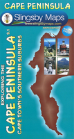
£35.00
A model anchor, brass paperweight- the perfect desk accessory. When sailors were gone for months or even years their return was a joyful & festive occasion for family & friends. To announce a safe homecoming a small iron or brass anchor was displayed next to the family cottage entrance. The local priest or pastor often blessed these little anchors during church service before the sailor left for a new & uncertain voyage. If we do not have this item in stock we will order it for you from our supplier. Delivery generally takes 3 weeks within the UK. For overseas delivery queries please email sales@stanfords.co.uk ...
Archived Product
£10.99
Historical map, based on old Argentinian naval charts, showing positions of numerous shipwrecks in the perilous waters around Tierra del Fuego, the Beagle Channel & around Cape Horn. Beautiful little drawings with names of lost ships indicate the type & size of the vessels: sailing ships, steamboats, modern ships, naval vessels, etc., & mark locations of the wrecks. On land the map shows historical lighthouses, gold mining settlements, gold mines & church missions. The map covers most of the Argentinian part of Tierra del Fuego, south of Cabo Peñas to the Beagle Channel, Isla de los Estados, Isla del Navarino & the small islands stretching southwards to Cape Horn. Latitude & longitude lines are drawn at 30’ intervals. Map legend is in Spanish only. In the margin is a long list of just some of the ships lost in these waters between 1643 & 1990. ...
Archived Product
£14.99
This is the story of Bernard & Francoise Moitessier's honeymoon voyage from Europe to the islands of the Pacific & back by way of Cape Horn. Setting out from Tahiti, they took the logical route because it was the fastest, taking them through the Roaring Forties, through the high latitudes of never ceasing gale-force winds & through iceberg territory. Their survival was due to careful preparation, great seamanship & their sense of harmony with their boat, Joshua, & the sea. ...
Archived Product
£9.95
Cape Peninsula on a double-sided, A2-size map stretching from the northern suburbs of Cape Town, with Robben Island shown as an inset. Relief is very effectively depicted by contours at 20m intervals, hill shading, & spot heights. Within the build-up areas colours distinguish residential districts, industrial zones, open public spaces, shopping districts, etc. Throughout the map an overprint highlights accommodation facilities from hotels to campsites, picnic areas, outdoor recreation centres incl. golf, paragliding & horse riding, beaches with watersport & diving facilities, bird watching areas, vineyards, view points, & other places of interest. Hiking paths are clearly marked. The map shows no geographical coordinates, but has an index listing all the major attractions & various facilities. ...
Archived Product
£12.95
Cape Peninsula on a double-sided, handy A2-size map at 1:50, 000 with excellent presentation of the topography, the road network & hiking trails, numerous places of interest & recreational sites, GPS waypoints, etc. Coverage extends north beyond central Cape Town to the city ...
Archived Product
£22.99
Cape Point & the southern half of the Cape Peninsula & the Table Mountain National Park including Simon’s Town, on a double-sided, contoured, GPS compatible map at 1:25, 000 from Slingsby Maps with hiking trails & a wealth of other tourist information. The map has contours at 5m intervals, enhanced by additional colouring for woodlands & sandy areas, with numerous spot heights & names of various topographic features. Boundaries of nature protective areas & restricted entry zones are clearly marked. Road network indicates private roads with or without public access, signposts, parking areas, etc. Hiking trails are annotated with distances & walking times, & show approved or not recommended sections. Extensive overprint highlights numerous facilities & places of interest including drinking water points, viewpoints, sport & recreational sites, best animal watching places, campsites & other tourist accommodation, restaurants, etc. The map has numerous GPS waypoints for road junctions & other important locations, plus UTM grid lines at 200m intervals & latitude/longitude lines at 1’ intervals. The map, researched & drawn by Peter Slingsby
- renowned environmental educator & cartographer, is illustrated by colour photos of local fauna & flora & has additional notes with tips for visitors.
...
Archived Product
£11.50
Cape Region of South Africa, including the whole of the Garden Route, at 1:500, 000 on a light, waterproof & tear-resistant, indexed road map with a street plan of Cape Town & a map of the Cape Peninsula, published by Reise Know-How as part of their highly acclaimed World Mapping Project. The map is double-sided to provide the best balance between a good scale & a convenient size sheet, & divides the region east/west. On the western part coverage within the Western Cape Province extends north along the Atlantic coast to just beyond Bitterfontein & 31° latitude, &

Includes::
part of the Northern Cape Province with the Hantamdberg, Roggeveldberge & Komsberge mountains & the Tankwa-Karoo National Park. The eastern half of the map extends beyond Port Elizabeth to Grahamstown & inland to Karoo National Park & Camdeboo NP & Mountain Zebra NP. Topography is presented by altitude colouring with contours, spot heights, mountain passes & names mountain ranges. The map also shows salt lakes & seasonal rivers, etc. Road network

Includes::
untarred local roads & selected 4WD tracks, & shows driving distances on main & many secondary routes. Railways are included & local airfields are also marked. National parks, game reserves & other protected areas are prominently marked. Symbols highlight numerous places of interest, including UNESCO world heritage sites, archaeological sites, hot springs & caves, viewpoints, beaches, wine growing regions, etc. Also shown are locations of selected campsites. The map is indexed & has latitude & longitude lines drawn at 30’ intervals. Map legend

Includes::
English. Also provided are a large clear street plan of Cape Town central districts plus a regional map at 1:200, 000 showing the city with the Cape Peninsula. Both show various places of interest.


...
Archived Product
£9.50
Cape Region of South Africa, including the whole of the Garden Route, at 1:500, 000 on a light, waterproof & tear-resistant, indexed road map with a street plan of Cape Town & a map of the Cape Peninsula, published by Reise Know-How as part of their highly acclaimed World Mapping Project. The map is double-sided to provide the best balance between a good scale & a convenient size sheet, & divides the region east/west. On the western part coverage within the Western Cape Province extends north to just beyond Bitterfontein & 31 ...
Archived Product
£7.99
Cape Reinga Coastal Walkway along the northernmost tip of New Zealand’s North Island at 1:75, 000 in a series of contoured & GPS compatible maps from New Topo NZ Ltd, with exceptionally vivid presentation of the terrain, routes clearly highlighted, & symbols to show locations of various facilities. In addition to the NZ national grid lines also has latitude & longitude grid at 10’ intervals. Contour interval is 20m. Maps in the series from New Topo NZ Ltd cover the country’s popular hiking & tramping areas. The maps have contours (20m in most titles
- please confirm in the individual description) enhanced by relief shading, plus colouring and/or graphics to indicate various types of the terrain & vegetation: glaciers, scree, lava flows, shingle, s&, swamps, exotic forest, scrub, native bush, etc. The overprint for the routes distinguishes, as appropriate, between tramping tracks & routes, walking tracks, & waymarked or unmarked trails. Symbols show facilities such huts, campsites, public toilets, viewpoints, car parks, etc. Where useful, the maps also have brief notes about hut reservations. All the titles are GPS compatible, most with a 1-km NZ national grid (GPS users can uses WGS84). To see all the titles in this series please click on the series link.
...
Archived Product
£12.99
Cape Town Baedeker is divided into four main categories
- background, practicalities, tours & A-Z of sites. The guide is introduced
...
Archived Product

Cape Peninsula

Cape Peninsula on a double-sided, handy A2-size map at 1:50, 000 with excellent presentation of the topography, the road network and hiking trails, numerous places of interest and recreational sites, GPS waypoints, etc. Coverage extends north beyond central Cape Town to the city’s northern districts and includes Robben Island shown as an inset. Relief is very effectively depicted by contours at 20m intervals, hill shading, altitude colouring and spot heights. Road network includes small local roads, indicates restricted access routes and shows driving distances on main and secondary roads. Many road junctions and other locations are annotated with GPS waypoints. Railway lines are shown with stations. The map shows numerous hiking trails and symbols highlight various places of
interest, including beaches and locations for diving and various water sports, bird watching sites, wineries, etc. The index arranged by different types of activities or attractions.To see other titles in this series please click on the series link.
RIP - This product is no longer available on our network. It was last seen on 25.09.2019

This page now acts as a permanent archive for this product. Add more information using the comments box below to ensure it can still be found by future generations.

Use our search facility to see if it is available from an alternative contributor.
  • External links may include paid for promotion
  • Availability: Out Of Stock
  • Supplier: Stanfords
  • SKU: 9781920377366
Availability: In Stock
£19.99

Product Description

Cape Peninsula on a double-sided, handy A2-size map at 1:50, 000 with excellent presentation of the topography, the road network & hiking trails, numerous places of interest & recreational sites, GPS waypoints, etc. Coverage extends north beyond central Cape Town to the city’s northern districts &

Includes::
Robben Island shown as an inset. Relief is very effectively depicted by contours at 20m intervals, hill shading, altitude colouring & spot heights. Road network

Includes::
small local roads, indicates restricted access routes & shows driving distances on main & secondary roads. Many road junctions & other locations are annotated with GPS waypoints. Railway lines are shown with stations. The map shows numerous hiking trails & symbols highlight various places of interest, including beaches & locations for diving & various water sports, bird watching sites, wineries, etc. The index arranged by different types of activities or attractions. To see other titles in this series please click on the series link.

Reviews/Comments

Add New

Intelligent Comparison

Oooops!
We couldn't find anything!
Perhaps this product's unique.... Or perhaps we are still looking for comparisons!
Click to bump this page and we'll hurry up.

Price History

Vouchers

No voucher codes found.
Do you know a voucher code for this product or supplier? Add it to Insights for others to use.

Facebook

Jargon Buster

GPS - Global Positioning System - Global position using satellites
Hiking - An outdoor activity envolving walking in nature
water - A chemical substance. Chemical formula H2O.
Size - is the measurement of how big an object is in space.
Network - A link and communication between things. Often computers or people.
Small - something that takes up less space than normal.
Road - a manmade lane or a path that is used to speed up travel.
Altitude - Something that can be quite high in relation to sea or ground level.

Supplier Information

Stanfords
Stanfords was established in 1853 and opened their iconic Covent Garden flagship store in 1901. They have become the top retailer of maps, travel books and accessories in the UK and arguably offer the largest selection of maps and travel books worldwide. Famous names such as Captain Robert Falcon Scott, Ranulph Fiennes and Michael Palin have purchased from Stanfords. They now have a shop in Bristol and both stores together with other venues operate a calendar of events including talks, book signings and exhibitions. As a specialist map retailer, the map selection is comprehensive and includes road maps, street maps and walking maps from worldwide destinations, as well as a selection of world atlases and wall maps. Books include travel guides and travel literature. Stanfords also stock globes, from miniatures made of blue marble to magnificent floor-standing globes. The website features a selection of interesting articles on travel topics.
Page Updated: 2023-11-12 20:15:36

Community Generated Product Tags

Oh No! The productWIKI community hasn't generated any tags for this product yet!
Menu