
 United Kingdom
 France
 Germany
 Netherlands
 Sweden
 USA
USA
 Italy
Italy
 Spain
Spain
More From Contributor


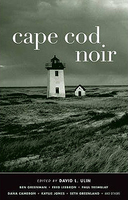
Cape Cod Noir
Los Angeles Times book critic David L. Ulin has been holidaying in Cape Cod, Massachusetts, every summer since he was a boy. He knows the terrain inside out - enough to identify the squalid underbelly of this allegedly idyllic location. His editing prowess is a perfect match for this fine volume. Features brand-new stories by David L Ulin, Ben Greenman, Lizzie Skurnick, Dana Cameron, Jedidiah Berry, Paul Tremblay, Vincent McCaffery, Seth Greenland, Kaylie Jones, Adan Mansbach, Elyssa East, Fred Leebron, William Hastings and others.

Product Description
Reviews/Comments
Add New
Intelligent Comparison
Archived Product

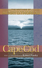
Cape Cod Stanfords
£8.95
Archived Product
Cape Cod, MA Stanfords
£6.50
Vouchers
No voucher codes found.
Do you know a voucher code for this product or supplier? Add it to Insights for others to use.
Do you know a voucher code for this product or supplier? Add it to Insights for others to use.
 Denmark