More From Contributor

£18.00
Plans: Primel Riviere Le Leguer Trebeurden Ploumanac'h Anse de Perros Perros-Guirec Port-Blanc Approaches to Riviere de Treguier Treguier Approaches to Riviere de Trieux & Paimpol Port de la Corderie (Ile de Brehat) Port Clos (Ile de Brehat) Lezardrieux Paimpol St-Quay-Portrieux Binic Port du Legue Dahouet 2009 edition

Includes::
extensive updating throughout. Some areas of the chart redrawn to improve positional accuracy.

Includes::
latest depths in Anse de Perros & the approaches to Le Trieux. Buoyage in the approaches to Riviere de Treguier & Le Legue fully updated.


...
Archived Product
£12.99
Topographic survey of Catalonia at 1:25, 000 from the Institut Cartogràfic i Geològic de Catalunya, an attractive alternative to Spain’s national topographic survey at this scale, offering a much larger area per sheet with extensive tourist information & vivid presentation of vegetation & land use. These large, detailed maps have contours at 10m intervals enhanced by hill shading & fine colouring and/or graphics to portray of vegetation or land use (different types of woodlands, marshl&, vineyards, crops, etc). An overprint highlights waymarked local & long-distance GR footpaths plus CT cycling routes. Also highlighted are picturesque locations such as villages, isolated buildings or natural features. A very wide range of symbols indicate various facilities, places of interest & recreational sites: tourist information centres, campsites & other rural accommodation, cultural heritage, vineries, wildlife observation areas, viewpoints & beauty spots, sites for recreational pursuits including horse riding, water sports, paragliding, etc The maps are divided by the publishers into three types: Administrative Units, Natural Protected Areas, & Geographical Areas, as shown on our grid for this series. Coverage by each sheet varies; most maps present an area of 30 x 23km (19 x 14km approx). The maps have a 1km UTM grid, with latitude & longitude values shown for the map corners. Excellently presented topographic map legend is in Catalan only but the legend for the tourist information & the road network

Includes::
English. To see the list of all the titles in this series please click on the series link.

...
Archived Product
£13.95
Cap de Creus Park Natural at 1:25, 000 in an extensive & very popular series of walking maps from Editorial Alpina covering the Pyrenees, Catalonia & other selected hiking areas in Spain, including Picos de Europa, Sierra Nevada & parts of Andaluc ...
Archived Product
£14.99
Cap de Creus Natural Park on the Costa Brava at 1:25, 000 on a contoured & GPS compatible map from Editorial Alpina, plus a booklet which

Includes::
English language descriptions several recommended hiking trails, accommodation details, etc. Topography is presented by contours at 10m intervals with relief shading & plenty of spot heights, plus colouring and/or graphics for different types of vegetation. An overprint highlights local & long-distance waymarked hiking trails & mountain bike routes. Symbols indicate different types of accommodation including campsites & youth hostels, sport & recreational facilities, interesting trees, etc. Road network shows locations of car parks & petrol stations. The map has a 1km UTM grid, plus latitude & longitude margin ticks at 1’ intervals. Map legend

Includes::
English. Accompanying booklet has 25 pages in English, providing descriptions of 12 recommended walks in the park plus four longer hikes, also contact details of local accommodation including campsites, descriptions of various places of interest, etc. To see the list of titles in this Editorial Alpina series which provides coverage of most popular hiking areas of Spain please click on the series link.


...
Archived Product
£6.95
Topographic coverage of the Balearic Islands at 1:50, 000 in the MTN50 (Mapa Topográfico Nacional) series from the Instituto Geográfico Nacional – Centro Nacional de Información Geografica, the country’s civilian survey organization. The maps have contours at 20m intervals, enhanced by relief shading, plus colouring and/or graphics to show different types of terrain, vegetation or land use. Boundaries of national parks & other protected areas are marked. In addition to all the usual information featured on topographic mapping at this scale: detailed presentation of the road & rail networks, rural tracks & paths, etc, the maps also show campsites & mountain refuges. On more recent editions some GRs, the official long-distance hiking routes, are also marked (although not as clearly as on hiking maps from other publishers). The MTN50 series was begun in late 1990s. Each map covers 28.5x 18.5 km (with adjustments in the coastal areas). The maps have a 1-km UTM grid, plus margin ticks for latitude & longitude at 1` intervals. Map legend is in Spanish only. To see other titles in this series please click on the series link. ...
Archived Product
£7.95
The name Lancelot ` Capability` Brown has become synonymous with the eighteenth-century English landscape garden: between 1751 & 1783 his consultancy handled over 170 major commissions. Ruthlessly efficient, he could stake out the `capabilities` of a particular terrain within an hour on horseback. Rising to the position of Master Gardener to George III, his trademark features included bald lawns, clumped trees, lakes & enclosing belts of woodland on the estate`s perimeter. With this standard park formula Brown & his followers held the commercial monopoly on garden design well into the following century, resisting the more rugged topography advocated by Richard Payne Knight`s new generation of Romantics. ...
Archived Product
£45.00
Widely acknowledged as the most influential l&- scape designer of his age, Lancelot Capability Brown was to England what Frederick Law Olmsted was to America responsible for shaping the very ideal of the nation s parkl&. Brown s ambition was to bring out of a landscape the best of its potential rather than impose his own ideas upon it. His designs are organic, weaving gestures of colour & perspective into the features that the country already afforded. So natural are his designs, & so perfectly do they complement the houses within them, that for many a Capability Brown landscape is the epitome of the English estate. His gardens & park- lands as much as the houses themselves would become icons of British country life. Published to coincide with the tercentenary of his birth, this remarkable book illuminates fifteen of Brown s most celebrated landscapes. To love the great English estates is to love the settings with which Brown surrounded them from idyllic parklands at Milton & Broadlands to structured landscapes around iconic houses at Blenheim, Burghley, Wake- field, & Chatsworth. With photography commissioned for the book, & including rarely seen archival drawings that shed light on Brown s process, this book serves as a guide to Britain s most beloved landscapes & an exploration of the masterful mind behind their creation. ...
Archived Product
£8.99
Cape Breton Island – the north-eastern part of Nova Scotia on an indexed map at 1:300, 000, plus indexed street maps of its main towns. The map of Cape Breton Island indicates unpaved roads, with driving distances marked on main routes. Railway lines & ferry connections are marked & the map indicates locations with scheduled air services. Symbols show numerous places of interest including campsites, beaches & scuba diving sights, wildlife watching areas, recreational facilities, etc. Cape Breton Highlands National Park is prominently highlighted & numerous small rivers & lakes are named. No geographical coordinates are provided; the index is next to the map. Indexed street maps at 1:25, 000 cover Sydney, Sidney Mines
- North Sydney, Antigonish, Baddeck, Dominion
- Glace Bay, Louisburg, New Waterford, Port Hwakesbury, & Truro. The map also

Includes::
a list of ferry operators with contact details, plus a distance table for Canada’s Atlantic Provinces. To see the list of currently available Canadian province & regional maps form the Map Art / Canadian Cartographics Corporation / JDM Géo publishing group, including waterproof & tear-resistant Fast Track titles, please click on the series link.


...
Archived Product
£8.95
This new paperback edition of Henry D. Thoreau`s compelling account of Cape Cod contains the complete, definitive text of the original. Introduced by American poet & literary critic Robert Pinsky
- himself a resident of Cape Cod
- this volume contains some of Thoreau`s most beautiful writings. In the plants, animals, topography, weather, & people of Cape Cod, Thoreau finds ”another world.” Encounters with the ocean dominate this book, from the fatal shipwreck of the opening chapter to his later reflections on the Pilgrims` landing & reconnaissance. Along the way, Thoreau relates the experiences of fishermen & oystermen, farmers & salvagers, lighthouse-keepers & ship captains, as well as his own intense confrontations with the sea as he travels the land`s outermost margins. Chronicles of exploration, settlement, & survival on the Cape lead Thoreau to reconceive the history of New England
- & to recognize the parochialism of history itself.


...
Archived Product

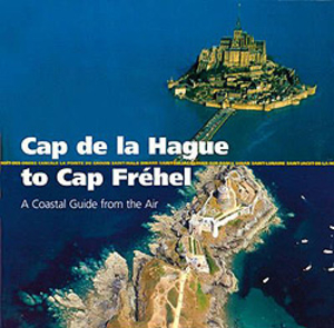
Cap De La Hague To Cap Frehel - A Coastal Guide From The Air

This attractive planning guide provides the perfect way to view the coastline for sailors, motorboaters, fishermen and walkers. The superb colour photos show the outlines of the coast, suitable anchorages, harbour entrances and river estuaries, and the accompanying text focuses on places of interest (such as castles, lookout points, villages, churches, and places of historical interest), as well as cycle routes and coastal walks. Although aimed primarily at seafarers it will be of equal use to holidaymakers, walkers, riders and cyclists. The first title in the series covers the most popular French coastal area for UK sailors - from Cherbourg to St Malo.
RIP - This product is no longer available on our network. It was last seen on 25.09.2019

This page now acts as a permanent archive for this product. Add more information using the comments box below to ensure it can still be found by future generations.

Use our search facility to see if it is available from an alternative contributor.
  • Availability: Out Of Stock
  • Supplier: Stanfords
  • SKU: 9781408112762
Availability: In Stock
£15.99

Product Description

This attractive planning guide provides the perfect way to view the coastline for sailors, motorboaters, fishermen & walkers. The superb colour photos show the outlines of the coast, suitable anchorages, harbour entrances & river estuaries, & the accompanying text focuses on places of interest (such as castles, lookout points, villages, churches, & places of historical interest), as well as cycle routes & coastal walks. Although aimed primarily at seafarers it will be of equal use to holidaymakers, walkers, riders & cyclists. The first title in the series covers the most popular French coastal area for UK sailors
- from Cherbourg to St Malo.

Reviews/Comments

Add New

Intelligent Comparison

Oooops!
We couldn't find anything!
Perhaps this product's unique.... Or perhaps we are still looking for comparisons!
Click to bump this page and we'll hurry up.

Price History

Vouchers

No voucher codes found.
Do you know a voucher code for this product or supplier? Add it to Insights for others to use.

Facebook

Jargon Buster

UK - United Kingdom - An island nation in Europe
Colour - The categorised spectrum of light visable to humans
Popular - Something that is admired and liked by many people.

Supplier Information

Stanfords
Stanfords was established in 1853 and opened their iconic Covent Garden flagship store in 1901. They have become the top retailer of maps, travel books and accessories in the UK and arguably offer the largest selection of maps and travel books worldwide. Famous names such as Captain Robert Falcon Scott, Ranulph Fiennes and Michael Palin have purchased from Stanfords. They now have a shop in Bristol and both stores together with other venues operate a calendar of events including talks, book signings and exhibitions. As a specialist map retailer, the map selection is comprehensive and includes road maps, street maps and walking maps from worldwide destinations, as well as a selection of world atlases and wall maps. Books include travel guides and travel literature. Stanfords also stock globes, from miniatures made of blue marble to magnificent floor-standing globes. The website features a selection of interesting articles on travel topics.
Page Updated: 2023-11-12 20:15:36

Community Generated Product Tags

Oh No! The productWIKI community hasn't generated any tags for this product yet!
Menu