More From Contributor
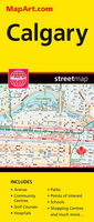
£6.99
From the Oscar-nominated & Bafta-award-winning creators of animated films Belleville Rendez Vous & The Illusionist comes a hilarious, dark-edged comedy caper full of twists & surprises. Caleb`s dad has vanished & only his abandoned taxi cab provides the clue to his last movements. But can Caleb solve the mystery of his missing dad before the greedy Money Mongers snatch him up
- just like they did his best friend Myra? In a crazy world of eccentric characters & villainous greed, Caleb must put his foot down & drive for the truth! Sylvain & Sally Chomet bring their unique & cinematic art & storytelling to their first ever original children`s book.
...
Archived Product
£4.95
Caledonian Canal & the Great Glen map by GEOproject, from Inverness to Fort William via Fort Augustus, shows details of navigation & facilities available to the boat user with details of boatyard & boat trip operators, as well as useful snippets of visitor information for places of interest not far from the water ...
Archived Product
£6.95
Topographic coverage of mainland Spain at 1:50, 000 in the MTN50 (Mapa Topográfico Nacional) series from the Centro Nacional de Información Geografica, the country’s civilian survey organization. The maps have contours at 20m intervals, enhanced by relief shading, plus colouring and/or graphics to show different types of terrain, vegetation or land use. Boundaries of national parks & other protected areas are marked. In addition to all the usual information featured on topographic mapping at this scale, detailed presentation of the road & rail networks, rural tracks & paths, etc, the maps also show campsites & mountain refuges. On more recent editions some GRs, the official long-distance hiking routes, are also marked (although not as clearly as on hiking maps from other publishers). Each map covers 29.5x 18.5 km (with adjustments in the border or coastal areas). The maps have a 1-km UTM grid, plus margin ticks for latitude & longitude at 1` intervals. Map legend is in Spanish only.HOW TO CHOOSE THE RIGHT 50K MAP: all the titles in CNIG’s 200K Provincial Road Maps series at 1:200, 000 are overprinted with the grid for the 1:50, 000 maps & can be used to see the area covered by each 50K title. TO SEE THE LIST OF TITLES IN THIS SERIES PLEASE CLICK ON THE SERIES LINK.PLEASE NOTE
- MAP TITLES: the grids shown on our website serve both the civilian & the military 1:50, 000 topographic series. Although the areas covered by maps in both series are identical (apart from some border or coastal sheets), occasionally map titles differ – only one title is shown on the grid, usually the military one. In Galicia, the Basque country & in the Catalan speaking areas the tendency now is to use local place names rather than the often better known Castilian ones. Where possible, both versions are included in our titles. Map titles listed on our website are based on information received by us at the time of publication, but sometimes maps arrive showing a completely different title! As long as the map number is as ordered, the correct map has been supplied.
...
Archived Product
£6.50
Topographic coverage of the Canary Islands at 1:25, 000 published by the Instituto Geográfico Nacional – Centro Nacional de Información Geografica, the country’s civilian survey organization. The maps have contours at 10m intervals & colouring and/or graphics to show different types of vegetation or land use. Boundaries of national parks & other protected areas are marked. In addition to all the usual information shown on topographic mapping at this scale: detailed presentation of the road network with rural tracks & paths, etc, the maps also show campsites. The maps have a 1-km UTM grid, plus margin ticks for latitude & longitude at 1` intervals. The majority of the titles have been published since late 1990s. Map legend is in Spanish only.COVERAGE: each 25K map covers one quarter of the corresponding 1:50, 000 map, with the numbering system: I = NW quarter, II = NE quarter, III = SW quarter, & IV = SE quarter. To see other titles in this series please click on the series link. ...
Archived Product
£36.95
Military topographic survey mapping with contours. These maps are designed primarily as flying charts for aircraft, but they are useful as general topographical maps where nothing else is available. Contours are shown in feet, with elevation colouring & spot heights. Towns, villages, major roads, railways & airports are shown (but please note that many of the smaller settlements are not named, & the road information is not necessarily up to date). Some air navigation information also appears on the map, such as radio beacons & restricted flying zones. Double-sided sheet. ...
Archived Product
£23.99
Street atlas of Calgary & Southern Alberta, Aidrie, Banff, Beiseker, Black Diamond, Bragg Creek, Brooks, Canmore, Chestermere, Coaldale, Cochrane, Crowsnest Pass, Crossfield, Drumheller, High River, Innisfail, Irricana, Lake Louise, Medicin Hat, Okotoks, Olds, Red Deer, Redwood Meadows, Strathmore, Taber & Turner Valley. The atlas is part of an extensive coverage of Canadian cities & towns from the country’s largest map publisher, Map Art. The mapping is usually at 1:25, 000 or 1:31, 250. Colouring distinguishes general build-up areas, shopping centres, public buildings & institutions, historical sites & places of interest, parks, etc. One way streets & pedestrian zones are indicated & a wide range of symbols shows parking facilities, bus terminals, metro and/or railway stations, various public facilities & services, places of interest, recreational centres, etc. Local neighbourhoods are named & municipal & quadrant boundaries are marked. In titles covering more than one city or town, each section is accompanied by overview maps indicating areas covered by the street plans. Each title has a full street index for all localities covered by it. Map legend is either bilingual in English & French or in English only.* Please note:* following a number changes among Canadian cartographic publishers maps previously published by Map Art Publishing may now be available under one of the following imprints: Map Art, Canadian Cartographics Corporation or JDM Géo Inc. Within a series, therefore, some titles may still be published as Map Art whilst others will be available as Canadian Cartographics Corporation or JDM Géo Inc. ...
Archived Product
£10.99
Waterproof & tear-resistant Fast Track map presenting in a handy-size format a street plan of Calgary & a road map of the nearby national & provincial parks in the Rocky Mountains, both at 1:250, 000, plus a more detailed street plan of downtown Calgary & plans of the main holiday resorts. On one side Calgary with its outer suburbs & western environs is presented at 1:250, 000, highlighting various facilities & places of interest. The downtown part of the city is also shown in mote detail at 1:21, 000. On the reverse coverage at 1:250, 000 is extended along the Trans-Canada Highway westwards to Canmore, Banff, Lake Louise & Golden, with Radium Hot Springs at the southern edge of the map. Cartography of this popular tourist region which

Includes::
the Banff, Yoho & Kootenay National Parks & the Mount Assiniboine Provincial Park is well presented by relief shading with plenty of names of peaks, ridges, ranges, etc. Road network indicates paved, unpaved & unimproved roads; the map also shows the railway line which follows closely the course of the Trans-Canada Highway. Symbols indicate locations of campsites, tourist information offices, various places of interest, etc. Both the Calgary map & coverage of the Rocky Mountains have a 10km UTM grid & a joint index listing communities, roads, parks, places of interest & ski areas. Also provided are street plans of Banff, Lake Louise, Canmore, Golden & Radium Hot Springs, indicating main places of interest. To see the list of currently available Canadian province & regional maps form the Map Art / Canadian Cartographics Corporation / JDM Géo publishing group, including waterproof & tear-resistant Fast Track titles, please click on the series link.

...
Archived Product
£8.99
Double-sided, indexed street plan of Calgary presenting the city at 1:28, 000. Coverage

Includes::
Calgary`s

...
Archived Product
£24.95
Street atlas of Calgary & the surrounding area, including Aidire, Banff, Black Diamond, Bragg Creek, Calgary, Canmore, Chestermere, Cochrane, Crossfield, High River, Irricana, Okotoks, Redwood Meadows, Strathmore, & Turner Valley. The atlas is part of an extensive coverage of Canadian cities & towns from the country ...
Archived Product

Calgary

Double-sided, indexed street plan of Calgary, including an enlargement at 1:12, 500 for the downtown area. The index includes lists of points of interest, arenas, shopping centres, golf courses, etc., as well as a list of districts.MapArt street plans are usually produced at 1:25, 000 or 1:31, 250, with smaller towns often shown at more detailed scales. All plans have street indexes. Plans grouping together several smaller towns often have an overview map of the whole of the relevant area. On street plans colouring distinguishes general build-up areas, shopping centres, public buildings and institutions, historical sites and places of interest, parks, etc. One way streets and pedestrian zones are indicated and a wide range of symbols shows parking facilities, bus terminals,
metro and/or railway stations, various public facilities and services, places of interest, recreational centres, etc. Local neighbourhoods are named and municipal and quadrant boundaries are marked. Map legend is either bilingual in English and French or in English only. Please note: street plans and atlases currently available from MapArt are gradually being changed into the Canadian Cartographics Corporation imprints, with some titles published at different scales or with different additional insets to those specified on our website. Information is being regularly updated as it becomes available from the publishers.
RIP - This product is no longer available on our network. It was last seen on 25.09.2019

This page now acts as a permanent archive for this product. Add more information using the comments box below to ensure it can still be found by future generations.

Use our search facility to see if it is available from an alternative contributor.
  • External links may include paid for promotion
  • Availability: Out Of Stock
  • Supplier: Stanfords
  • SKU: 9781553683025
Availability: In Stock
£6.50

Product Description

Double-sided, indexed street plan of Calgary, including an enlargement at 1:12, 500 for the downtown area. The index

Includes::
lists of points of interest, arenas, shopping centres, golf courses, etc., as well as a list of districts. Map Art street plans are usually produced at 1:25, 000 or 1:31, 250, with smaller towns often shown at more detailed scales. All plans have street indexes. Plans grouping together several smaller towns often have an overview map of the whole of the relevant area. On street plans colouring distinguishes general build-up areas, shopping centres, public buildings & institutions, historical sites & places of interest, parks, etc. One way streets & pedestrian zones are indicated & a wide range of symbols shows parking facilities, bus terminals, metro and/or railway stations, various public facilities & services, places of interest, recreational centres, etc. Local neighbourhoods are named & municipal & quadrant boundaries are marked. Map legend is either bilingual in English & French or in English only. Please note: street plans & atlases currently available from Map Art are gradually being changed into the Canadian Cartographics Corporation imprints, with some titles published at different scales or with different additional insets to those specified on our website. Information is being regularly updated as it becomes available from the publishers.

Reviews/Comments

Add New

Price History

Vouchers

No voucher codes found.
Do you know a voucher code for this product or supplier? Add it to Insights for others to use.

Facebook

Jargon Buster

Wide - Something with a large width.
Golf - A sport played on a large outside grass course, the aim to hit a small ball with a club into small holes.

Supplier Information

Stanfords
Stanfords was established in 1853 and opened their iconic Covent Garden flagship store in 1901. They have become the top retailer of maps, travel books and accessories in the UK and arguably offer the largest selection of maps and travel books worldwide. Famous names such as Captain Robert Falcon Scott, Ranulph Fiennes and Michael Palin have purchased from Stanfords. They now have a shop in Bristol and both stores together with other venues operate a calendar of events including talks, book signings and exhibitions. As a specialist map retailer, the map selection is comprehensive and includes road maps, street maps and walking maps from worldwide destinations, as well as a selection of world atlases and wall maps. Books include travel guides and travel literature. Stanfords also stock globes, from miniatures made of blue marble to magnificent floor-standing globes. The website features a selection of interesting articles on travel topics.
Page Updated: 2023-11-12 20:15:36

Community Generated Product Tags

Oh No! The productWIKI community hasn't generated any tags for this product yet!
Menu