More From Contributor

£19.95
This Imray’s series of charts for the Western Europe

Includes::
comprehensive & easy-to-use sailing charts

...
Archived Product
£19.95
Imray’s series of charts of Northwest Europe are comprehensive & easy-to-use sailing charts published on rip-proof, waterproof paper- ideal to be used on small tables or in cockpits. They show detailed coastline & depth information, & are constantly corrected to reflect latest information. The C Charts offer coverage for cruising on larger-size sheets; they are suitable for offshore passage making & the medium scales chosen also allow safe inshore navigation. This chart

Includes::
plans/insets of the following locations:- Weymouth Harbour- Lulworth Cove- Worbarrow Bay- Swanage- Studland Bay- Christchurch- River Stour Each chart contains insets showing local harbours annotated with symbols indicating what facilities can be found there (marinas, mooring & berth facilities, fuel, water, chandlers, etc.). Depths are shown in metres. Charts are fully updated to the latest printing date, & often include further corrections on a separate sheet. Subsequent corrections can be found on the Imray website. Positions referring to WGS84 Datum, such as most GPS readings, can be plotted directly onto these charts. Base cartography uses contours, several levels of colour shading, & spot measurements to indicate depth relative to Lowest Astronomical Tide, including distinct colour highlighting for tidally-covered l&. A large number of hatchings & markings are used to indicate coast types, salt flats, marshl&, etc. Compliant IALA ‘ System A’ buoys are clearly marked, & indications of other navigational aides such as light floats are given where possible. Lighthouses are clearly marked with arcs of visibility. A complex & comprehensive system of symbols is used to indicate all types of submerged obstructions, including wrecks, rocks, pipelines & cables, with depths where known. Flood tides, eddies races, ebb tide streams & other current information is given. A wide range of symbols indicate onshore features, anchorages, harbour details & other points of note. Danger areas, restricted areas & traffic zones are all shown.

...
Archived Product
£19.95
Plans included: Le Croisic (1:15 000) Saint-Nazaire (1:25 000) Pornic (1:12 500) L` Herbaudiere (1:12 500) Goulet de Fromentine (1:30 000) Port-Joinville (Ile d` Yeu) (1:10 500) Port de Saint-Gilles-Croix-de-Vie (1:15 000) Les Sables d` Olonne (1:20 000) For this 2014 edition, the chart has been completely revised & updated throughout. ...
Archived Product
£19.95
This Imray’s series of charts for the Western Europe

Includes::
comprehensive & easy-to-use sailing charts

...
Archived Product
£19.95
Plans included: Approach to Arcachon Capbreton Rada de Higuer Getaria Zumaia Abra de Bilbao Santoña Santander Also


...
Archived Product
£19.95
This Imray’s series of charts for the Western Europe

Includes::
comprehensive & easy-to-use sailing charts

...
Archived Product
£19.95
Plans: Bridport Harbour Lyme Regis Exmouth Tor Bay Teignmouth Harbour Torquay Harbour Brixham Harbour River Dart Entrance 2010 edition. Fully updated throughout.

Includes::
revised details of jetties, pontoons, etc. at Lyme Regis, Torquay & Brixham, plus the latest depth surveys in Teignmouth Harbour & the River Exe entrance.

...
Archived Product
£19.95
Plans included: Sines Lagos Portimao Vilamoura Vila Real de Santo Antonio Isla Cristina Mazagon Chipiona Rota Bahia de Cadiz Puerto Sherry Sancti-Petri Barbate Tarifa Gibraltar Strait of Gibraltar NEW EDITION
-

Includes::
revision of Strait of Gibraltar TSS, major changes at Gibraltar & new port details (Tangier-Med) on the coast of Morocco. Portimao plan has also been redrawn at a larger scale.


...
Archived Product
£19.95
Plans included: Pwllheli (1:12 500) Aberdovey (1:25 000) Aberystwyth (1:15 000) Aberaeron (1:20 000) New Quay (1:20 000) Aberporth (1:30 000) Cardigan (1:40 000) Newport Bay (1:35 000) Fishguard (1:18 000) Entrance to Milford Haven (1:30 000) On this 2015 edition the chart has been fully updated throughout. Revised depths are shown at Aberdovey, Fishguard, the waters south of St David`s Head & in the entrance to Milford Haven. ...
Archived Product
£19.95
This Imray’s series of charts for the Western Europe

Includes::
comprehensive & easy-to-use sailing charts

...
Archived Product

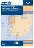
C48 A Coruna To Porto

Plans included: A Coruna (1:50 000) Ria de Corme e Laxe (1:75 000) Ria de Camarinas (1:50 000) Ria de Muros (1:75 000) Approaches to Ria de Arousa (1:150 000) Ria de Arousa (1:150 000) Cabo de Cruz (1:40 000) Vilagarcia (1:35 000) Illa de Arousa to Cambados (1:40 000) Ria de Pontevedra (1:150 000) Ria de Vigo (1:150 000) Baiona (1:85 000) Viana do Castelo (1:30 000) Leixoes (1:20 000) Barra do Rio Douro (1:20 000)
RIP - This product is no longer available on our network. It was last seen on 25.09.2019

This page now acts as a permanent archive for this product. Add more information using the comments box below to ensure it can still be found by future generations.

Use our search facility to see if it is available from an alternative contributor.
  • Availability: Out Of Stock
  • Supplier: Stanfords
  • SKU: 9781846236846
Availability: In Stock
£19.95

Product Description

Plans included: A Coruna (1:50 000) Ria de Corme e Laxe (1:75 000) Ria de Camarinas (1:50 000) Ria de Muros (1:75 000) Approaches to Ria de Arousa (1:150 000) Ria de Arousa (1:150 000) Cabo de Cruz (1:40 000) Vilagarcia (1:35 000) Illa de Arousa to Cambados (1:40 000) Ria de Pontevedra (1:150 000) Ria de Vigo (1:150 000) Baiona (1:85 000) Viana do Castelo (1:30 000) Leixoes (1:20 000) Barra do Rio Douro (1:20 000)

Reviews/Comments

Add New

Intelligent Comparison

Oooops!
We couldn't find anything!
Perhaps this product's unique.... Or perhaps we are still looking for comparisons!
Click to bump this page and we'll hurry up.

Price History

Vouchers

No voucher codes found.
Do you know a voucher code for this product or supplier? Add it to Insights for others to use.

Facebook

Jargon Buster

Supplier Information

Stanfords
Stanfords was established in 1853 and opened their iconic Covent Garden flagship store in 1901. They have become the top retailer of maps, travel books and accessories in the UK and arguably offer the largest selection of maps and travel books worldwide. Famous names such as Captain Robert Falcon Scott, Ranulph Fiennes and Michael Palin have purchased from Stanfords. They now have a shop in Bristol and both stores together with other venues operate a calendar of events including talks, book signings and exhibitions. As a specialist map retailer, the map selection is comprehensive and includes road maps, street maps and walking maps from worldwide destinations, as well as a selection of world atlases and wall maps. Books include travel guides and travel literature. Stanfords also stock globes, from miniatures made of blue marble to magnificent floor-standing globes. The website features a selection of interesting articles on travel topics.
Page Updated: 2023-11-12 20:15:36

Community Generated Product Tags

Oh No! The productWIKI community hasn't generated any tags for this product yet!
Menu