More From Contributor
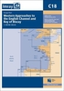
£14.95
Crete in the Blue Guides series focuses primarily on cultural tourism for the visitor who wishes to understand more of what they might see &, as such, the title provides thorough & objective reference information covering art, history & architecture. The guide features illustrations aimed to inform rather than just decorate, such as maps, diagrams, floor plans, architectural details & photographs. Cross referenced indexing means information is accessible & layout navigable. Selective listings of restaurants & accommodation are chosen in the belief that good, practical recommendations will contribute to the enjoyment of good art & culture. ...
Archived Product
£7.99
Cote d' Azur in the Landmark Visitor Guides series, exploring a range of places in Britain, Europe & the Caribbean, with a particular expertise in UK destinations. Each guide presents the reader with detailed, wide-ranging & accessible overview of the region or area, with a particular focus on history & culture, notable local attractions, the landscape, local events & family activities. A series of recommended walks & guided car tours exploring the region are also included in each title. The guides are arranged geographically by region & are ideal both for short & longer breaks, with practical guidance on recommended routes & tourist attractions, in addition to insightful inset boxes into local history, culture & traditions. Information on accommodation, restaurants & day-to-day information are more limited, though a compact Directory at the end of each guide provides basic listings of recommended accommodation & restaurants, as well as tourist information contacts & regional event calendars. International destinations also carry climate & country facts, basic phrases & other general travel practical guidance for travelling to the region. The British titles in the Landmark Visitor Guides series are highly recommended, covering titles that are rarely available from other publishers. ...
Archived Product
£12.00
The latest in the Alphabet Cooking series covering the A to Z of trending cuisines, this fun, easy recipe book features all the essential recipes to give Caribbean cooking a go: jerk ribs / fried okra / macaroni pie / pumpkin curry / chow / rice & peas / creole pelau / saltfish fritters / mackerel rundown / jerk pulled pork / rum punch / coconut toto / callaloo / crab dumplings / cuba libre ...
Archived Product
£19.95
Imray’s series of charts of Northwest Europe are comprehensive & easy-to-use sailing charts published on rip-proof, waterproof paper- ideal to be used on small tables or in cockpits. They show detailed coastline & depth information, & are constantly corrected to reflect latest information. The C Charts offer coverage for cruising on larger-size sheets; they are suitable for offshore passage making & the medium scales chosen also allow safe inshore navigation. This chart is a passage chart of the Thames Estuary, from Tilbury to North Foreland & Orfordness. Each chart contains insets showing local harbours annotated with symbols indicating what facilities can be found there (marinas, mooring & berth facilities, fuel, water, chandlers, etc.). Depths are shown in metres. Charts are fully updated to the latest printing date, & often include further corrections on a separate sheet. Subsequent corrections can be found on the Imray website. Positions referring to WGS84 Datum, such as most GPS readings, can be plotted directly onto these charts. Base cartography uses contours, several levels of colour shading, & spot measurements to indicate depth relative to Lowest Astronomical Tide, including distinct colour highlighting for tidally-covered l&. A large number of hatchings & markings are used to indicate coast types, salt flats, marshl&, etc. Compliant IALA ‘ System A’ buoys are clearly marked, & indications of other navigational aides such as light floats are given where possible. Lighthouses are clearly marked with arcs of visibility. A complex & comprehensive system of symbols is used to indicate all types of submerged obstructions, including wrecks, rocks, pipelines & cables, with depths where known. Flood tides, eddies races, ebb tide streams & other current information is given. A wide range of symbols indicate onshore features, anchorages, harbour details & other points of note. Danger areas, restricted areas & traffic zones are all shown. ...
Archived Product
£19.95
This Imray’s series of charts for the Western Europe

Includes::
comprehensive & easy-to-use sailing charts

...
Archived Product
£19.95
This Imray’s series of charts for the Western Europe

Includes::
comprehensive & easy-to-use sailing charts

...
Archived Product
£19.95
Imray’s series of charts of Northwest Europe are comprehensive & easy-to-use sailing charts published on rip-proof, waterproof paper- ideal to be used on small tables or in cockpits. They show detailed coastline & depth information, & are constantly corrected to reflect latest information. The C Charts offer coverage for cruising on larger-size sheets; they are suitable for offshore passage making & the medium scales chosen also allow safe inshore navigation. This chart

Includes::
plans/insets of the following locations:- La Coruna- Bayona- Leixoes- Lisboa Approaches- Cascais- Sines- Lagos- Bahia de Cádiz- Rota- Strait of Gibraltar- Gibraltar Each chart contains insets showing local harbours annotated with symbols indicating what facilities can be found there (marinas, mooring & berth facilities, fuel, water, chandlers, etc.). Depths are shown in metres. Charts are fully updated to the latest printing date, & often include further corrections on a separate sheet. Subsequent corrections can be found on the Imray website. Positions referring to WGS84 Datum, such as most GPS readings, can be plotted directly onto these charts. Base cartography uses contours, several levels of colour shading, & spot measurements to indicate depth relative to Lowest Astronomical Tide, including distinct colour highlighting for tidally-covered l&. A large number of hatchings & markings are used to indicate coast types, salt flats, marshl&, etc. Compliant IALA ‘ System A’ buoys are clearly marked, & indications of other navigational aides such as light floats are given where possible. Lighthouses are clearly marked with arcs of visibility. A complex & comprehensive system of symbols is used to indicate all types of submerged obstructions, including wrecks, rocks, pipelines & cables, with depths where known. Flood tides, eddies races, ebb tide streams & other current information is given. A wide range of symbols indicate onshore features, anchorages, harbour details & other points of note. Danger areas, restricted areas & traffic zones are all shown.

...
Archived Product
£19.95
This Imray’s series of charts for the Western Europe

Includes::
comprehensive & easy-to-use sailing charts

...
Archived Product
£19.95
This Imray’s series of charts for the Western Europe

Includes::
comprehensive & easy-to-use sailing charts

...
Archived Product
£19.95
Plans included: Wick Bay Helmsdale Inverness Firth Inverness Nairn Burghead Hopeman Lossiemouth Buckie Banff & Macduff Fraserburgh Peterhead Aberdeen Stonehaven Montrose Arbroath This edition has been fully updated with revised depths applied throughout, in particular at Wick Bay, Burghead, Montrose Harbour, Aberdeen & the approaches to Inverness Firth. Harbour developments are shown at Wick Bay, Peterhead & Aberdeen. ...
Archived Product

C15 The Solent

Plans River Hamble (1:12, 500) River Itchen (1:12, 500) Hythe Marina Village (1:10, 000) Lymington River (1:14, 000) Newtown River (1:20, 000) Bembridge Harbour (1:10, 000) Beaulieu River (1:20, 000) Cowes Harbour (1:20, 000) Yarmouth Harbour (1:4500) Wootton Creek (1:20, 000) Includes the latest known depth surveys and racing buoy information.
RIP - This product is no longer available on our network. It was last seen on 25.09.2019

This page now acts as a permanent archive for this product. Add more information using the comments box below to ensure it can still be found by future generations.

Use our search facility to see if it is available from an alternative contributor.
  • Availability: Out Of Stock
  • Supplier: Stanfords
  • SKU: 9781786790118
Availability: In Stock
£19.95

Product Description

Plans River Hamble (1:12, 500) River Itchen (1:12, 500) Hythe Marina Village (1:10, 000) Lymington River (1:14, 000) Newtown River (1:20, 000) Bembridge Harbour (1:10, 000) Beaulieu River (1:20, 000) Cowes Harbour (1:20, 000) Yarmouth Harbour (1:4500) Wootton Creek (1:20, 000)

Includes::
the latest known depth surveys & racing buoy information.

Reviews/Comments

Add New

Intelligent Comparison

Oooops!
We couldn't find anything!
Perhaps this product's unique.... Or perhaps we are still looking for comparisons!
Click to bump this page and we'll hurry up.

Price History

Vouchers

No voucher codes found.
Do you know a voucher code for this product or supplier? Add it to Insights for others to use.

Facebook

Jargon Buster

Supplier Information

Stanfords
Stanfords was established in 1853 and opened their iconic Covent Garden flagship store in 1901. They have become the top retailer of maps, travel books and accessories in the UK and arguably offer the largest selection of maps and travel books worldwide. Famous names such as Captain Robert Falcon Scott, Ranulph Fiennes and Michael Palin have purchased from Stanfords. They now have a shop in Bristol and both stores together with other venues operate a calendar of events including talks, book signings and exhibitions. As a specialist map retailer, the map selection is comprehensive and includes road maps, street maps and walking maps from worldwide destinations, as well as a selection of world atlases and wall maps. Books include travel guides and travel literature. Stanfords also stock globes, from miniatures made of blue marble to magnificent floor-standing globes. The website features a selection of interesting articles on travel topics.
Page Updated: 2023-11-12 20:15:36

Community Generated Product Tags

Oh No! The productWIKI community hasn't generated any tags for this product yet!
Menu