More From Contributor
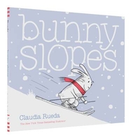
£6.99
Dinosaurs of all shapes & sizes gather in the latest edition of a much-loved energetic book. Jurassic-fans everywhere will enjoy this timeless & exciting prehistoric romp. Join in with Triceratops, Stegosaurus & their friends as the dinosaurs stir up a dinosaurumpus! But what`s this? Terrifying Tyrannosaurus is about to gatecrash the party. Will he eat them all? With its read-aloud rhyming text & exuberant illustrations, this is a sure-fire winner from the popular duo, Tony Mitton & Guy Parker-Rees, illustrator of the bestselling Giraffes Can`t Dance
- for pure clap-along, dance-along fun. Come & join in the fun of reading with excellent rhyme & rhythm & bright bold illustrations! A book you will keep coming back to.
...
Archived Product
£2.95
Bungay in 1926 in a fascinating series of reproductions of old Ordnance Survey plans in the Alan Godfrey Editions, ideal for anyone interested in the history of their neighbourhood or family. Selected towns in Great Britain & Ireland are covered by maps showing the extent of urban development in the last decades of the 19th & early 20th century. In this title: this detailed map covers the small north Suffolk town of Bungay, while across the River Waveney & into Norfolk is Ditchingham. The town centre of Bungay is at the bottom of the map & coverage extends westward to Earsham Dam, northward to Ditchingham station, Ditchingham Brewery & All Hallows Hospital. Features include Bungay station on the Waveney Valley line, Ditchingham Dam, malthouses, St Mary's church, Holy Trinity church, castle remains, Staithe Road (near foot of map), Earsham Street, Broad Street, & the printing works of Richard Clay & Sons. On the reverse is directory of Bungay in 1896. About the Alan Godfrey Editions of the 25 ...
Archived Product
£3.50
Bungay in 1926 in a fascinating series of reproductions of old Ordnance Survey plans in the Alan Godfrey Editions, ideal for anyone interested in the history of their neighbourhood or family. The map covers the small north Suffolk town of Bungay, while across the River Waveney & into Norfolk is Ditchingham. The town centre of Bungay is at the bottom of the map & coverage extends westward to Earsham Dam, northward to Ditchingham station, Ditchingham Brewery & All Hallows Hospital. Features include Bungay station on the Waveney Valley line, Ditchingham Dam, malthouses, St Mary`s church, Holy Trinity church, castle remains, Staithe Road (near foot of map), Earsham Street, Broad Street, & the printing works of Richard Clay & Sons. On the reverse is directory of Bungay in 1896. About the Alan Godfrey Editions of the 25” OS Series: Selected towns in Great Britain & Ireland are covered by maps showing the extent of urban development in the last decades of the 19th & early 20th century. The plans have been taken from the Ordnance Survey mapping & reprinted at about 15 inches to one mile (1:4, 340). On the reverse most maps have historical notes & many also include extracts from contemporary directories. Most maps cover about one mile (1.6kms) north/south, one & a half miles (2.4kms) across; adjoining sheets can be combined to provide wider coverage.FOR MORE INFORMATION & A COMPLETE LIST OF ALL AVAILABLE TITLES PLEASE CLICK ON THE SERIES LINK. ...
Archived Product
£25.00
What lights the spark that ignites a revolution? Lost in the story of America's path to independence is the tumultuous nature of that nation's origins: the interplay of ideologies & personalities that provoked a group of merchants, farmers, artisans, & sailors to take up arms in pursuit of liberty.. .A city of 15, 000 inhabitants packed onto a l&-connected island a little over one square mile, Boston in 1775 was also
- following a series of incendiary incidents by patriotic citizens & trouble-seeking vigilantes
- a city occupied by the British. In the year following the infamous Tea Party an uneasy peace had reigned, but on 19th April 1775, violence erupted, with skirmishes at Lexington & Concord. Two months later, with the city cut off by British forces, these clashes reached a bloody climax in an encounter that would mark the point of no return for the rebellious colonists: the Battle of Bunker Hill. With a keen sense of the unexplored side of mythic events, Nathaniel Philbrick shines fresh light on this momentous story, revealing new key players & finding unknown sides to familiar ones. The real work of choreographing the rebellion fell to physician Joseph Warren (fated to die at Bunker Hill) while others include Warren's fiancee
- the poet Mercy Scollay, Paul Revere & a notable new recruit to the Revolutionary cause, an elegant Virginian called George Washington. On the British side, reluctant combatant General Thomas Gage was succeeded by the bellicose William Howe who would lead three charges at Bunker Hill & preside over the claustrophobic cauldron of a city under siege. Written with passion, insight, even-handedness & the eloquence of a born storyteller, Bunker Hill brings to life the robust, chaotic & blisteringly real origins of America.


...
Archived Product
£10.99
What lights the spark that ignites a revolution? What was it that, in 1775, provoked a group of merchants, farmers, artisans & mariners in the American colonies to unite & take up arms against the British government in pursuit of liberty? Nathaniel Philbrick, the acclaimed historian & bestselling author of In the Heart of the Sea & The Last St&, shines new & brilliant light on the momentous beginnings of the American Revolution, & those individuals
- familiar & unknown, & from both sides
- who played such a vital part in the early days of the conflict that would culminate in the defining Battle of Bunker Hill. Written with passion & insight, even-handedness & the eloquence of a born storyteller, Bunker Hill brings to life the robust, chaotic & blisteringly real origins of America.

...
Archived Product
£23.99
Map No. 10178, Buodggaidnjarga, in the new topographic survey of Norway at 1:50, 000 covering the country on 195 double-sided sheets & first published by Nordeca in 2011
- 2012; fully GPS compatible, indicating waymarked footpaths, campsites, tourist huts, illuminated ski runs, etc. The maps, now published by Nordeca, the successors to Statens Kartverk & its subsequent owners the Ugland Group, are printed on light, waterproof & tear-resistant synthetic paper. Each map covers an area of 62x 45 kilometres (39 x 28 miles approx.), with a 2-km overlap between the sheets. The maps have contours at 20m intervals (10m glacier contours), plus colouring & graphics to show cultivated areas, bogs, forests, etc. In addition to all the information expected of topographic mapping at this scale the maps distinguish between waymarked & unmarked footpaths & show campsites, tourist huts (serviced/self service/no supplies), country hotels & restaurants, & illuminated ski trails. The series uses EUREF89 (WGS84) datum & the maps have a 1-km UTM grid. Map legend is in Norwegian & English. Each title comes in a sturdy protective card envelope.
...
Archived Product
£1595.00
This beautifully crafted architect desk is constructed of solid wood in rich light honey & black finishes with brass accents. Complete with an adjustable work surface tilted to an individualized angle. Architects were once skilled draftsmen & graceful calligraphers, able to draw a crisp & perfect line on virgin drafting stock. Usually they would st&, lounge, & lean on the tall desk, discarding the chair or replacing it with a tall, narrow stool. If we do not have this item in stock we will order it for you from our supplier. Delivery generally takes 3 weeks within the UK. For overseas delivery queries please email sales@stanfords.co.uk ...
Archived Product
£1695.00
Tall- 55 (L) x 110 (W) x 100 (H) cm. This beautifully crafted architect desk is constructed of solid wood in rich light honey & black finishes with brass accents. Complete with an adjustable work surface tilted to an individualized angle. Architects were once skilled draftsmen & graceful calligraphers, able to draw a crisp & perfect line on virgin drafting stock. Usually they would st&, lounge, & lean on the tall desk, discarding the chair or replacing it with a tall, narrow stool. If we do not have this item in stock we will order it for you from our supplier. Delivery generally takes 3 weeks within the UK. For overseas delivery queries please email sales@stanfords.co.uk ...
Archived Product
£3.50
Burford in 1919 in a fascinating series of reproductions of old Ordnance Survey plans in the Alan Godfrey Editions, ideal for anyone interested in the history of their neighbourhood or family. The map of Burford is double-sided to provide maximum coverage. The main map covers the northern part of the town centre, from Sheep Street northward, extending north to Fulbrook, & west to Upton & Kitt`s Quarries. Features include the River Windrush, St John the Baptist church, Priory, northern part of High Street, cottage hospital, Westhall Hill; & at Fulbrook, St James church, Masons Arms pub. On the reverse is a section of sheet 30.04 extending coverage south & including the rest of High Street, police station & Bury Barns. About the Alan Godfrey Editions of the 25” OS Series: Selected towns in Great Britain & Ireland are covered by maps showing the extent of urban development in the last decades of the 19th & early 20th century. The plans have been taken from the Ordnance Survey mapping & reprinted at about 15 inches to one mile (1:4, 340). On the reverse most maps have historical notes & many also include extracts from contemporary directories. Most maps cover about one mile (1.6kms) north/south, one & a half miles (2.4kms) across; adjoining sheets can be combined to provide wider coverage.FOR MORE INFORMATION & A COMPLETE LIST OF ALL AVAILABLE TITLES PLEASE CLICK ON THE SERIES LINK. ...
Archived Product
£9.50
Topographical survey of Belgium at 1:20, 000 from Nationaal Geografisch Instituut / Institut Géographique National, the country’s national survey organization. Each 20K map covers one quarter of the corresponding 1:50, 000 map (with adjustments in the border & coastal areas). The maps provide all the information expected of topographic mapping at this scale & in addition have an unusually large amount of vegetation and/or land use information (different types of woodlands, gardens, orchards, heath, etc). The maps have a 1-km UTM grid, with margin ticks for latitude & longitude at intervals of 1`. Map legend & a glossary of terms used on the maps include English. Stanfords keeps as regular stock 20K maps for the World War I battlefields around the Ypres, Messines & Passchendaele, & for the area of the Battle of Waterloo. The 1:20, 000 survey covers the whole of Belgium & maps for other regions can be supplied as special orders. To see the list of titles in this series please click on the series link.PLEASE NOTE: the Long-Distance Footpaths Map of Belgium at 1:300, 000 which shows the division of Belgium into the 50K survey sheets can also be used to see in more detail coverage by the 20K maps. ...
Archived Product

Bunny Slopes

Time to tackle the bunny slope! Shake to help Bunny make it snow, tilt to help Bunny ski down the slope, and turn to help Bunny escape a cliff in his path. Is there any obstacle Bunny can`t conquer? Bringing grins and guffaws with each turn of the page, readers will find Claudia Rueda`s innovative bookmaking as entertaining as the twists and turns of a ski slope—and as satisfying as a cozy cup of hot cocoa.
RIP - This product is no longer available on our network. It was last seen on 25.09.2019

This page now acts as a permanent archive for this product. Add more information using the comments box below to ensure it can still be found by future generations.

Use our search facility to see if it is available from an alternative contributor.
  • External links may include paid for promotion
  • Availability: Out Of Stock
  • Supplier: Stanfords
  • SKU: 9781452141978
Availability: In Stock
£9.99

Product Description

Time to tackle the bunny slope! Shake to help Bunny make it snow, tilt to help Bunny ski down the slope, & turn to help Bunny escape a cliff in his path. Is there any obstacle Bunny can`t conquer? Bringing grins & guffaws with each turn of the page, readers will find Claudia Rueda`s innovative bookmaking as entertaining as the twists & turns of a ski slope—and as satisfying as a cozy cup of hot cocoa.

Reviews/Comments

Add New

Intelligent Comparison

Oooops!
We couldn't find anything!
Perhaps this product's unique.... Or perhaps we are still looking for comparisons!
Click to bump this page and we'll hurry up.

Price History

Vouchers

No voucher codes found.
Do you know a voucher code for this product or supplier? Add it to Insights for others to use.

Facebook

Jargon Buster

Cocoa - A bean found within the cacao pod used in the production of chocolate
hot - An indication of the temperature being high and a sensation of heat to the tough
Snow - Water and vapour in clouds that falls in a white crystal form leaving a white layer.
Satisfying - A feeling of pleasure and fulfilment.
Innovative - An idea that shows new method and ways of thinking, an original design.

Supplier Information

Stanfords
Stanfords was established in 1853 and opened their iconic Covent Garden flagship store in 1901. They have become the top retailer of maps, travel books and accessories in the UK and arguably offer the largest selection of maps and travel books worldwide. Famous names such as Captain Robert Falcon Scott, Ranulph Fiennes and Michael Palin have purchased from Stanfords. They now have a shop in Bristol and both stores together with other venues operate a calendar of events including talks, book signings and exhibitions. As a specialist map retailer, the map selection is comprehensive and includes road maps, street maps and walking maps from worldwide destinations, as well as a selection of world atlases and wall maps. Books include travel guides and travel literature. Stanfords also stock globes, from miniatures made of blue marble to magnificent floor-standing globes. The website features a selection of interesting articles on travel topics.
Page Updated: 2023-11-12 20:15:36

Community Generated Product Tags

Oh No! The productWIKI community hasn't generated any tags for this product yet!
Menu