
 United Kingdom
 France
 Germany
 Netherlands
 Sweden
 USA
USA
 Italy
Italy
 Spain
Spain
More From Contributor


Buenos Aires Borch
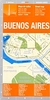
Clear, indexed, tourist street plan on durable laminated paper showing central Buenos Aires at 1:15, 000, with more generalised road maps of the greater urban area and surrounding region on the reverse. Street map detail includes one-way streets, notable buildings, public buildings, shopping malls, railway and metro lines and stations, and ferry links. Symbols denote information centres, monuments, places of worship, theatres, sites of interest, car parks, hospitals, hotels, bus stations, embassies and post offices. The main map coverage includes Puerto Madero and much of the docks area and extends from Constitución and Telmo districts in the south east to Palermo in the north west. Insets continue the coverage into Boca in the south east and Núñez in the north west.
The road map of the larger urban area is at 1;75, 000 and includes Tigre, San Isidro and Avellaneda. It shows the main road and rail communications, district names, airports, museums and other tourist sites. There is also a diagram of the city’s metro and commuter rail network, a 1:530, 000 road map of the city and immediate surroundings, including La Plata, a 1:18, 000 plan of Isla Martín García, and a 1:3, 000, 000 road map of central Argentina. Thirty recommended attractions are highlighted on the maps. All the street and road maps are indexed for towns, streets and locations of interest as appropriate to the scale and level of detail, and the multilingual map legend includes English
The road map of the larger urban area is at 1;75, 000 and includes Tigre, San Isidro and Avellaneda. It shows the main road and rail communications, district names, airports, museums and other tourist sites. There is also a diagram of the city’s metro and commuter rail network, a 1:530, 000 road map of the city and immediate surroundings, including La Plata, a 1:18, 000 plan of Isla Martín García, and a 1:3, 000, 000 road map of central Argentina. Thirty recommended attractions are highlighted on the maps. All the street and road maps are indexed for towns, streets and locations of interest as appropriate to the scale and level of detail, and the multilingual map legend includes English

Product Description
Reviews/Comments
Add New
Intelligent Comparison
Archived Product

Buenos Aires Noir Stanfords
£11.99
Archived Product
Buenos Aires Stanfords
£8.50
Archived Product
Buenos Aires Stanfords
£11.95
Archived Product
Buenos Aires Stanfords
£10.39
Archived Product
Buenos Aires Stanfords
£5.99
Archived Product
Buenos Aires Stanfords
£9.99
Archived Product

Buenos Aires Stanfords
£14.95
Vouchers
No voucher codes found.
Do you know a voucher code for this product or supplier? Add it to Insights for others to use.
Do you know a voucher code for this product or supplier? Add it to Insights for others to use.
 Denmark