
 United Kingdom
 France
 Germany
 Netherlands
 Sweden
 USA
USA
 Italy
Italy
 Spain
Spain
More From Contributor


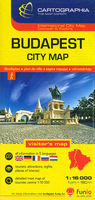
Budapest Extra Plan
Budapest within its administrative boundary at 1:30, 000 from Cartographia on an indexed map with an enlargement of the central area, detailed information on public transport networks, plus a map of the city’s environs.The plan used in this title is available in three separate versions: Extra, Classic and Comfort, all with the same basic cartography but with different additional features and formats. The plan covers the built-up areas within the city’s 23 administrative districts. Main traffic arteries are highlighted and the plan shows all the city’s public transport networks: tram, trolleybus, bus and express bus lines with numbers, plus metro and suburban railway lines with stops, and rack-railways. Main railway terminals and long-distance bus stations are also shown.
Symbols mark locations of various public buildings and facilities, including six different kinds of places of worship. Throughout the plan and on the enlargements streets are annotated with selected house numbers for easier identification of addresses. In the wooded areas along the edge of the Buda Hills spot heights shows the topography.Map legend includes English.* Budapest EXTRA plan with a card cover: the central districts of Buda and Pest are shown on an enlargement at 1:17, 500 with additional marking for one way streets. Also provided is an inset showing the city’s immediate environs. The index is in a separate booklet attached to the map cover and includes a diagram of the city’s night bus services.* Budapest CLASSIC plan with a soft-cover: same map as above but with the index
and the diagram of night bus lines printed on the reverse.* Budapest COMFORT plan, laminated and waterproof, with the map printed double-sided. The index is printed across the areas outside the city’s municipal boundary. No enlargement or additional features are provided. Map legend includes English but is less informative than in the other two versions.

Product Description
Reviews/Comments
Add New
Intelligent Comparison
Archived Product
Budapest City Plan Stanfords
£5.50
Archived Product
Budapest City Plan Stanfords
£6.50
Archived Product

Budapest Classic Plan Stanfords
£6.50
Archived Product

Budapest Comfort Plan Stanfords
£9.50
Vouchers
No voucher codes found.
Do you know a voucher code for this product or supplier? Add it to Insights for others to use.
Do you know a voucher code for this product or supplier? Add it to Insights for others to use.
 Denmark