
 United Kingdom
 France
 Germany
 Netherlands
 Sweden
 USA
USA
 Italy
Italy
 Spain
Spain
More From Contributor


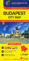
Budapest City Plan
Budapest at 1:16, 000 from Cartographia on an indexed plan covering the centre with the surrounding districts, plus an enlargement presenting the centre in greater detail, plus public transport diagrams including night bus services.On one side the plan at 1:16, 000 covers the city from the Buda Hills to the Hungexpo grounds, and north/south from the Hajógyári Island to the Rákóczi Bridge. Bus, tram and trolleybus routes are shown with line numbers; metro stations indicate numbers of the lines stopping there. Also marked and ferry services on the Danube. For drivers the map indicates main traffic arteries, one way or pedestrianized streets, and locations of car parks. Street index is on the reverse and includes a list of important sight, museums, bath and swimming pools, etc.
Map legend includes English.Also on the reverse, the city centre on both sides of the Danube is presented in greater detail at 1:10, 000, plus two diagrams showing the city’s metro/tram/suburban rail lines plus night services.
Map legend includes English.Also on the reverse, the city centre on both sides of the Danube is presented in greater detail at 1:10, 000, plus two diagrams showing the city’s metro/tram/suburban rail lines plus night services.

Product Description
Reviews/Comments
Add New
Vouchers
No voucher codes found.
Do you know a voucher code for this product or supplier? Add it to Insights for others to use.
Do you know a voucher code for this product or supplier? Add it to Insights for others to use.
 Denmark