More From Contributor

£120.00
Brussels, an original antique map by S.D.U.K., published in London, 1844. Steel plate, uncoloured. Map size 29 x 30 cm, overall mounted size 54 x 47.5 cm.A detailed map of Brussels published by the Society for the Diffusion of Useful Knowledge. The Society was founded by John, Earl Russell, & Henry Brougham, later Lord Chancellor of England in 1827. The Society's main purpose was to encourage universal literacy by publishing numbers of books of good quality that would be affordable to all. These town plans were published in perhaps the grandest of the Society's publications
- their atlas entitled Maps Of The Society For The Diffusion Of Useful Knowledge, first issued by Baldwin & Cradock, & then re-issued by other publishers, including Chapman & Hall & latterly Edward Stanford. The map

Includes::
a vignette view of Antwerp from the road to Mechlin, Brussels & Louvin. Along the bottom of the map the city's principal buildings are depicted. The map was engraved by B.R. Davies after W.B. Clarke. Antique maps from various original publishers are presented on the Stanford


...
Archived Product
£7.99
In this new edition, the Top 25 sights & experiences are now in one section. We`ve selected the must-see sights for you & put them in one place
- all you have to do is take your pick. If you want a bit more guidance, go to the new City Tours section, self-guided tours that bring you the best of the city. Or if you have extra time on your hands, turn to the More to See sights. Our new feature, Focus On, helps you to get to know the city in more depth. & we still include top tips on how to make the most of your trip, as well as great places to shop, eat, drink & sleep for every budget. But it`s not just a guidebook. As you would expect from the AA, your City Pack also comes with a weather-resistant map that has all the sights located on it. The map has even got its own wallet in the back so you can fold away for safe-keeping.
...
Archived Product
£9.99
Brussels region & the eastern part of the Flemish Brabant province of Belgium at 1:50, 000 in a series from Falk B.V. showing the network of signposted cycling routes on large, double-sided indexed maps with prominent highlighting of long-distance LF routes, symbols indicating accommodation & other tourist services, plus in each title two or more panels with recommended local circuits & additional tourist information. The Falk 50K cycling series, which

Includes::
some adjoining areas in Lower Saxony & has now been extended to cover Flanders, shows the extensive network of sign-posted cycling routes. The network consists of numbered junctions joined by sign-posted connecting routes in either direction. At each junction there is an information panel showing an overview map of the whole network with the junction numbers. A second panel shows all the intersections directly connected to that junction. The system enables cyclists to plan their own routes by preparing a list of junction numbers through which they want to travel. Falk maps give cycling distances between the junctions & indicate which roads, both within the numbered network & outside it, have separate cycling paths. Routes which are part of the LF network of long-distance cycle routes are clearly marked. A wide range of symbols shows various accommodation options, bars & restaurants, & various places of interest. Landscape information is provided by colouring for woodlands, dunes, etc. The maps are indexed & show in the margins latitude & longitude at 1`52” intervals. Map legend

Includes::
English.PLEASE NOTE: to see other titles in the Falk series please click on the series link, where the series description

Includes::
a comparison between the Falk maps & the ANWB cycling series also covering the Netherlands at 1:50, 000.


...
Archived Product
£25.00
Brussels can claim to be the Art Nouveau capital of Europe. This is the first comprehensive guide in English to individual buildings in eleven main areas of the city. For those wishing to devise their own tours & visits, there are specially-drawn maps & an index of architects & designers. A movement or design philosophy more than a precise style, Art Nouveau flourished c. 1893-1914, inspired by forms & patterns found in nature such as flowers & plants, clouds, waves, & even wisps of smoke. The influence of architects & designers rebelling against heavy Victorian conformity, spread from buildings & detailing to interior design, furniture, lighting, textiles & fittings; fine & decorative art including graphics, calligraphy, carved lettering & ceramics. The famous names are all here: Victor Horta, Paul Hankar & Henry Van de Velde; & their disciples, colleagues & successors, each with a short biography as a side note to the lavishly- illustrated text. ...
Archived Product
£24.95
(Re)discover Art Nouveau at the heart of Brussels. At the end of the 19th century, the anti-academic movement pushed Brussels` architects towards Art Nouveau. Both Victor Horta, in an organic style, & Paul Hankar, in a more geometrical tendency, created an architecture that quickly gained an international reputation. In a little more than a decade, from 1893 on, hundreds of Art Nouveau-fashioned buildings appeared in Brussels, elaborated first by the great pioneers & later by their students & imitators who are also influenced by the Vienna Secession & other trends of European Art Nouveau. At first, this style fulfilled industrial bourgeoisie`s dreams, yearning to assert itself in the city`s structure through this new, & sometimes exuberant, architecture. This book offers nine walks to discover
- in different districts
- the multiple aspects of architectural Art Nouveau in Brussels. Witness the personal style of the most important architects as well as decorative methods such as sgraffito. Through interviews with owners, custodians & restorers of Art Nouveau-styled buildings, Brussels Art Nouveau describes the fundamental guardians of this remarkable heritage.

...
Archived Product
£10.99
A street map of Brussels in a jigsaw format: Extra Goods introduces the pleasure of learning a city by play with a new series of magnetic puzzles reproducing the worlds major cites. This 100 pieces puzzle is presented in a beautiful tin box, decorated with a section of the street plan. The perfect gift for inhabitants, tourists & fans. The tin

Features:
- 100 pieces magnetic puzzle- dimensions: a puzzle surface of 26cm x 35 cm-

Dimensions of the box: height 9 cm; diameter 7 cm- up-to-date cartography supplied by by Falk Verlag- Made in Germany To see the list of other titles in this series please click on the series link.


...
Archived Product
£5.99
This is the savvy city breakers' pocket guide to seeing & doing more in Europe's cosmopolitan capital
- with a fun-seeking & cost-conscious
...
Archived Product
£5.50
Brussels in a series of handy size, detailed & indexed city centre street plans of main towns in the Netherlands & Flanders including Brussels from Falk, highlighting recommended walks & places of interest, with six best sights prominently marked & cross-referenced to brief descriptions. The plans also indicate publishers’ recommendations for shopping and/or bars & restaurants. The network of streets & small connecting passages is very clearly presented. Metro stations are marked & tram routes are shown with line numbers & stops. The plans show cycle paths & for drivers indicate main traffic arteries & car parks. Symbols show various facilities such as tourist information centres, markets, canal cruise offices, etc. On the reverse, the street index is accompanied by a calendar of main events, a list of museums, plus contact details for publishers’ recommendations. Map legend & all the text about recommended sights, etc, include English. To see the list of other titles in this series please click on the series link. ...
Archived Product
£4.99
Brussels in the Eyewitness Pocket Map & Guide series to world cities consists of a slim, mini guide, in a unique format, to the location’s major places of interest & an indexed pull out pocket map. Sights such as museums, galleries, churches & gardens/parks, as well as shops, restaurants & pubs are presented by area colour coding for quick reference. Contents are illustrated with colour images akin to the more substantial Dorling Kindersley guides & also provide basic introductory information & useful segments of practical tit-bits, with a spread of communications essentials vocabulary. Out of town trips are profiled &, where applicable, transport maps are also included. ...
Archived Product
£4.99
Central Brussels in a series of handy pocket street plans from Freytag & Berndt. Each map is laminated, so waterproof & tear-resistant, & highlights the publishers’ recommendations of five best choices in five categories: shopping, restaurants & cafes, culture, nightlife & sights. On one side is an indexed street plan annotated with colour-coded markers highlighting the publishers’ recommendations, all listed on the reverse of the map with brief notes in several languages. In larger cities the plans cover only the central districts. Also provided are a small road map of the city’s environs, if appropriate a diagram of the metro network, & a Fact Box with phone numbers for tourist offices, car hire & emergency services. Map legend & notes on the recommendations include English. To see other titles is this series please click on the series link. ...
Archived Product

Brussels Borch

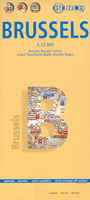
Tourist street plan for visitors to Brussels: clear, indexed, laminated and waterproof, highlighting 30 top sights. The main plan at 1:12, 000 extends from the Midi/Zuid station (Eurostar’s terminal) to the Exhibition grounds with the Atomium, and east/west from the Sacré-Cœur Basilique to the museums in the Cinquantenaire/Jubel Park. On the reverse, an enlargement at 1:10, 900 shows the central part of the city within the inner ring. Both maps show bilingual street names, indicate one way streets, and highlight metro stations, selected hotels, various facilities and places of interest, including the 30 top sights in the city. A map at 1:100, 000 covers the environs, showing access to the city by road. The indexes for all these maps include listings of both streets and
various sights/public buildings, etc. Also included is a diagram of the city’s metro network, a plan of the Grand Place/Groote Markt, information on climate/rainfall, etc, and a small administrative map of Belgium.*PLEASE NOTE:*The main plan does not extend south to include Avenue Louise and Ixelles or St Gilles districts with many of the city’s most important Art Nouveau buildings and the Horta Museum.
RIP - This product is no longer available on our network. It was last seen on 25.09.2019

This page now acts as a permanent archive for this product. Add more information using the comments box below to ensure it can still be found by future generations.

Use our search facility to see if it is available from an alternative contributor.
  • External links may include paid for promotion
  • Availability: Out Of Stock
  • Supplier: Stanfords
  • SKU: 9783866093553
Availability: In Stock
£8.99

Product Description

Tourist street plan for visitors to Brussels: clear, indexed, laminated & waterproof, highlighting 30 top sights. The main plan at 1:12, 000 extends from the Midi/ Zuid station (Eurostar’s terminal) to the Exhibition grounds with the Atomium, & east/west from the Sacré-Cœur Basilique to the museums in the Cinquantenaire/ Jubel Park. On the reverse, an enlargement at 1:10, 900 shows the central part of the city within the inner ring. Both maps show bilingual street names, indicate one way streets, & highlight metro stations, selected hotels, various facilities & places of interest, including the 30 top sights in the city. A map at 1:100, 000 covers the environs, showing access to the city by road. The indexes for all these maps include listings of both streets & various sights/public buildings, etc. Also included is a diagram of the city’s metro network, a plan of the Grand Place/ Groote Markt, information on climate/rainfall, etc, & a small administrative map of Belgium.*PLEASE NOTE:* The main plan does not extend south to include Avenue Louise & Ixelles or St Gilles districts with many of the city’s most important Art Nouveau buildings & the Horta Museum.

Reviews/Comments

Add New

Intelligent Comparison

Oooops!
We couldn't find anything!
Perhaps this product's unique.... Or perhaps we are still looking for comparisons!
Click to bump this page and we'll hurry up.

Price History

Vouchers

No voucher codes found.
Do you know a voucher code for this product or supplier? Add it to Insights for others to use.

Facebook

Jargon Buster

Waterproof - Resistant to water, usualy specified by depth in metres
MIDI - Musical Instrument Digital Interface - an industry standard to allow devices and musical instrument to interact.
Network - A link and communication between things. Often computers or people.
Small - something that takes up less space than normal.
Road - a manmade lane or a path that is used to speed up travel.
Museum - A building which exhibits old artefacts for viewing of people who show interest.
Laminated - A thin layer of plastic that gives a coating and shine to a material.

Supplier Information

Stanfords
Stanfords was established in 1853 and opened their iconic Covent Garden flagship store in 1901. They have become the top retailer of maps, travel books and accessories in the UK and arguably offer the largest selection of maps and travel books worldwide. Famous names such as Captain Robert Falcon Scott, Ranulph Fiennes and Michael Palin have purchased from Stanfords. They now have a shop in Bristol and both stores together with other venues operate a calendar of events including talks, book signings and exhibitions. As a specialist map retailer, the map selection is comprehensive and includes road maps, street maps and walking maps from worldwide destinations, as well as a selection of world atlases and wall maps. Books include travel guides and travel literature. Stanfords also stock globes, from miniatures made of blue marble to magnificent floor-standing globes. The website features a selection of interesting articles on travel topics.
Page Updated: 2023-11-12 20:15:36

Community Generated Product Tags

Oh No! The productWIKI community hasn't generated any tags for this product yet!
Menu