
 United Kingdom
 France
 Germany
 Netherlands
 Sweden
 USA
USA
 Italy
Italy
 Spain
Spain
More From Contributor


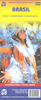
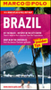

Brazil Michelin
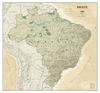
Brazil at 1:3, 850, 000 on a double-sided indexed map from Michelin with basic city maps of Rio de Janeiro and São Paulo, a distance table and information on traffic regulations. The map divides the country east/west with the substantial overlap between the two sides and the whole of the Amazon Basin with Mato Grosso showing on one side. Coverage includes the whole of Bolivia and Paraguay, northern Chile with Antofagasta and eastern Peru with Iquitos, Cusco and Arequipa.Topography is shown by graphics for swaps and occasional spot heights, plus relief shading for the Andes. Numerous tributaries of the Amazon are named and national parks and other protected areas are highlighted. Also marked are Indian Reservations.Road network includes selected minor local roads and unsurfaced tracks,
and gives distances on main and many secondary routes. Railway lines are included and local airports are marked. Symbols highlight various places of tourist interest. The map has latitude and longitude lines at intervals of 2° and is indexed. Map legend includes English.Also provided are basic street plans with main streets and places of interest in Rio de Janeiro and São Paulo, a distance table and motes on traffic regulations.
and gives distances on main and many secondary routes. Railway lines are included and local airports are marked. Symbols highlight various places of tourist interest. The map has latitude and longitude lines at intervals of 2° and is indexed. Map legend includes English.Also provided are basic street plans with main streets and places of interest in Rio de Janeiro and São Paulo, a distance table and motes on traffic regulations.

Product Description
Reviews/Comments
Add New
Vouchers
No voucher codes found.
Do you know a voucher code for this product or supplier? Add it to Insights for others to use.
Do you know a voucher code for this product or supplier? Add it to Insights for others to use.
 Denmark