More From Contributor
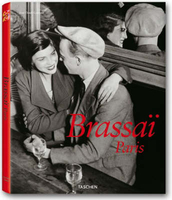
£6.50
Handy size street map with contours to show the topography & an enlargement for the town centre. Notable buildings & places of interest are highlighted. A range of symbols denotes many specific features e.g. hotels & campsites, restaurants, markets, filling stations, museums, car parks, etc. Many locations are numbered & listed on the reverse with the street index.A larger scale inset shows the city centre at 1:7, 500. Other insets show an overview of the region with access to the town at 1:180, 000, a street map of Stupini at 1:30, 000, & a plan of the Poiana Brasov area at 1:15, 000. Map legend

Includes::
English.

...
Archived Product
£7.99
Romanian towns of Brasov & Târgu Mures on a double-sided map from the Budapest-based Cartographia. Each town is shown with an enlargement of its central area, an index including lists of sights & facilities, plus a small road map of the surrounding region. On one side is a plan of Brasov at 1:15, 000; insets at reduced scales extend coverage to include Poiana Brasov & Stupini. On the reverse Târgu Mures is presented at 1:12, 000, with a smaller scale inset extending coverage to include Besa. Both plans highlight main traffic arteries, name important buildings & places of interest, & indicate various facilities including selected tourist accommodation, campsites, car parks & petrol stations, etc. Unusually for street plans, the base map has contours at 10m intervals & shows walks in the surrounding parkland & woodlands. Each town has an index of both streets & important buildings / sights. Map legend

Includes::
English.

...
Archived Product
£7.00
The Bel Alpin tourism map of Brasov county in Romania is a 1:250, 000 scale road map of one of Romania’s most popular tourist destinations, including detail of the Poiana Brasov ski region & Brasov old town. It also offers wide-ranging detailed descriptions of the area on the reverse. The map offers easy-to-read road mapping showing major highways, local roads, & some forest roads & footpaths. Filling stations are marked, & intermediate distances in kilometres are shown along many routes. Other transport information

Includes::
railway lines & stations.A large number of places of tourist interest are marked with symbols, although few have names given. These places include churches, monasteries, castles, spas & springs, museums & Dacian & Roman relics. The most popular & important of these visitor attractions have their map symbols highlighted for emphasis. The boundaries of national parks are also shown. The map marks many hotels, motels & pensions/boarding houses in the region, as well as mountain shelters & chalets, but names are not given. An inset map shows the Poiana Brasov ski resort area, Romania’s premier ski destination, in greater detail at 10, 000 scale. This shows cable cars & ski lifts, some ski lines, & some street details. Hotels, villas etc are also shown with names. This inset also shows contour lines at 20m intervals. Another inset shows a street plan of Brasov City, with 32 top sites highlighted & named, some with small pictures. A third inset map gives a national overview of Romania showing the principal road connections to Brasov region. The text descriptions on the reverse of the map, in English & Romanian, give detailed background information on the region; geography, population, churches & historical sites, key towns, feasts & festivals & an extensive section on the region’s history. It also covers top activities like climbing, walking & skiing.

...
Archived Product
£19.99
Brass 3 minute sandglass. The pocket glass of the boatswain. Used to measure ship’s speed, counting knots, timing minutes. A small gift with big presence. If we do not have this item in stock we will order it for you from our supplier. Delivery generally takes 3 weeks within the UK. For overseas delivery queries please email sales@stanfords.co.uk ...
Archived Product
£210.00
Brass Rolling Rule
- 18”/450mm Supplied to Naval personnel worldwide & manufactured from brass & stainless steel. Quality control
...
Archived Product
£11.99
Topographical survey of Belgium at 1:50, 000 from the country’s national survey organization, Nationaal Geografisch Instituut / Institut Géographique National. Contour interval varies according to the terrain, from 2.5 metres in the coastal areas to 10 metres in the Ardennes. The maps provide all the information expected of topographic mapping at this scale & in addition have an unusually large amount of vegetation and/or land use information (different types of woodlands, gardens, orchards, heath, etc). Each standard sheet covers Approx. 32 x 20 km / 20 x 12 miles, with larger maps published for the border or coastal areas. The maps have a 1-km UTM grid, with margin ticks for latitude & longitude at intervals of 1`. Map legend & a glossary of terms used on the maps include English.PLEASE NOTE: the Long-Distance Footpaths Map of Belgium at 1:300, 000 is overprinted with the grid for the 1:50, 000 topographic survey, showing the exact coverage of each sheet. Stanfords keeps as regular stock 50K maps for the World War I battlefields around the Ypres, Messines & Passchendaele, & for the area of the Battle of Waterloo. Maps for other regions can be supplied as special orders – to see the list of all the titles in this series please click on the series link. ...
Archived Product
£11.99
Topographical survey of Belgium at 1:20, 000 from Nationaal Geografisch Instituut / Institut Géographique National, the country’s national survey organization. Each 20K map covers one quarter of the corresponding 1:50, 000 map (with adjustments in the border & coastal areas). The maps provide all the information expected of topographic mapping at this scale & in addition have an unusually large amount of vegetation and/or land use information (different types of woodlands, gardens, orchards, heath, etc). The maps have a 1-km UTM grid, with margin ticks for latitude & longitude at intervals of 1`. Map legend & a glossary of terms used on the maps include English. Stanfords keeps as regular stock 20K maps for the World War I battlefields around the Ypres, Messines & Passchendaele, & for the area of the Battle of Waterloo. The 1:20, 000 survey covers the whole of Belgium & maps for other regions can be supplied as special orders. To see the list of titles in this series please click on the series link.PLEASE NOTE: the Long-Distance Footpaths Map of Belgium at 1:300, 000 which shows the division of Belgium into the 50K survey sheets can also be used to see in more detail coverage by the 20K maps. ...
Archived Product
£15.00
Think `grand cafe` & the image that immediately springs to mind is a decadent, smoke-filled place populated by coffee-drinking thinkers, writers & artists in 1930s Europe. Along with the brasserie, the grand cafe combines an opulent setting exclusively for the everyman. Zedel is such a place. Housed in a 1915 hotel off London`s Piccadilly Circus, it was restored to its former grandeur & re-opened in 2012 with all the charm & distinction of Art Deco Paris. In this book, A. A. Gill explores the origins of the grand cafe & pays homage to the character of Zedel. Much more than just a restaurant, Zedel houses a bustling cafe leading to a sweeping marble staircase, at the bottom of which are the Crazy Coqs cabaret, the Bar American cocktail bar, & the magnificent brasserie itself. Forty iconic brasserie recipes are included in the book, such as Soupe a l`oignon, Moules marinieres, Boeuf bourgignon, Profiteroles & Tarte au citron. Period photography & artwork help to capture the mood of this remarkable venue. ...
Archived Product
£11.99
From the fictional towns of Hill Valley, CA, & Shermer, IL, to the beautiful landscapes of the ” Goondocks” in Astoria & the ”time of your life” dirty dancing resort still alive & well in Lake Lure, NC, `80s teen movies left their mark not just on movie screen & in the hearts of fans, but on the landscape of America itself. Like few other eras in movie history, the `80s teen movies has endured & gotten better with time. In Brat Pack America, Kevin Smokler gives virtual tours of your favorite movies while also picking apart why these locations are so important to these movies. Including interviews with actors, writers, & directors of the era, & chock full of interesting facts about your favorite `80s movies, Brat Pack America is a must for any fan. Smokler went to Goonies Day in Astoria, OR, took a Lost Boys tour of Santa Cruz, CA, & deeply explored every nook & cranny of the movies we all know & love, & it shows. ...
Archived Product
£7.50
Large street map of the whole city with extra coverage of some outer suburbs: Marianka in the north, Devínska Nová Ves in the west, & Zahorská Bystrica, Jarovce, Rusovce & Cunovo in the south. Colours distinguish public buildings, industrial areas, parks, forests, vineyards. Detail

Includes::
one-way roads, pedestrian zones, steps, car parks & petrol stations. Railways & tram, trolleybus & bus routes are marked & a range of symbols denote such features as campsites, hospitals, police, information offices, churches, tv/radio masts, monuments, museums, post offices. Legend

Includes::
English translation. An enlargement of the city centre (1:5, 000) is included on the reverse along with a diagram of the public transport network & a list of the bus, trolleybus & tram routes. There is also a detailed 1:50, 000 topographic map of the city & close surroundings. The index is in a booklet attached to the map cover.


...
Archived Product

Brassai, Paris

Harlots, hoodlums, and heathens in Brassai`s Paris ”Brassai is a living eye, ” wrote Henry Miller of the Hungarian-born artist who adopted Paris after World War I and became one of its most celebrated photographers. Originally a painter before he moved on to writing, sculpture, cinema and, most famously, photography, Brassai (1899-1984) was a member of Paris`s cultural elite, counting Miller, Picasso, Sartre, Camus, and Cocteau, among his friends. Camera in hand, he scoured the streets and bars of Paris, unabashedly capturing the city`s inhabitants in their natural habitats. Prostitutes, hoodlums, and other `marginal` characters were the most famous heroes of Brassai`s moody, gritty photographs taken often by night. Including an extensive selection of Brassai`s finest
photographs and an essay describing his life and work, this book explores the world of Brassai in thematic chapters: Minotaure magazine, Paris at Night, Secret Paris, Day Visions, Artists of My Life, and Graffiti and Transmutations.
RIP - This product is no longer available on our network. It was last seen on 25.09.2019

This page now acts as a permanent archive for this product. Add more information using the comments box below to ensure it can still be found by future generations.

Use our search facility to see if it is available from an alternative contributor.
  • External links may include paid for promotion
  • Availability: Out Of Stock
  • Supplier: Stanfords
  • SKU: 9783836503891
Availability: In Stock
£7.99

Product Description

Harlots, hoodlums, & heathens in Brassai`s Paris ” Brassai is a living eye, ” wrote Henry Miller of the Hungarian-born artist who adopted Paris after World War I & became one of its most celebrated photographers. Originally a painter before he moved on to writing, sculpture, cinema &, most famously, photography, Brassai (1899-1984) was a member of Paris`s cultural elite, counting Miller, Picasso, Sartre, Camus, & Cocteau, among his friends. Camera in h&, he scoured the streets & bars of Paris, unabashedly capturing the city`s inhabitants in their natural habitats. Prostitutes, hoodlums, & other `marginal` characters were the most famous heroes of Brassai`s moody, gritty photographs taken often by night. Including an extensive selection of Brassai`s finest photographs & an essay describing his life & work, this book explores the world of Brassai in thematic chapters: Minotaure magazine, Paris at Night, Secret Paris, Day Visions, Artists of My Life, & Graffiti & Transmutations.

Reviews/Comments

Add New

Intelligent Comparison

Oooops!
We couldn't find anything!
Perhaps this product's unique.... Or perhaps we are still looking for comparisons!
Click to bump this page and we'll hurry up.

Price History

Vouchers

No voucher codes found.
Do you know a voucher code for this product or supplier? Add it to Insights for others to use.

Facebook

Jargon Buster

Eye - An organ which detects light
Camera - An electronic device used for taking photographs
Hand - A part of the body at the end of the arm
Hand - A pointer which indicates time on a clock face
Friends - A close associate or a popular US based sitcom about a group of friends
World - A physical grouping, commonly used to describe earth and everything associated with ti
Day - The time it takes a planet or other space objects to complete one rotation.
Natural - not manmade

Supplier Information

Stanfords
Stanfords was established in 1853 and opened their iconic Covent Garden flagship store in 1901. They have become the top retailer of maps, travel books and accessories in the UK and arguably offer the largest selection of maps and travel books worldwide. Famous names such as Captain Robert Falcon Scott, Ranulph Fiennes and Michael Palin have purchased from Stanfords. They now have a shop in Bristol and both stores together with other venues operate a calendar of events including talks, book signings and exhibitions. As a specialist map retailer, the map selection is comprehensive and includes road maps, street maps and walking maps from worldwide destinations, as well as a selection of world atlases and wall maps. Books include travel guides and travel literature. Stanfords also stock globes, from miniatures made of blue marble to magnificent floor-standing globes. The website features a selection of interesting articles on travel topics.
Page Updated: 2023-11-12 20:15:36

Community Generated Product Tags

Oh No! The productWIKI community hasn't generated any tags for this product yet!
Menu