More From Contributor
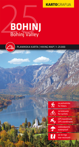
£5.95
Bogota in the Wallpaper City Guide series, published by Phaidon & encompassing a collection of pocket-size guides dedicated to the best design elements in major cities. Compiled by experts at the Wallpaper magazine, the guides are widely recognized for appealing to design-conscious travellers & are aimed at those interested in art, design & architecture. Each guide identifies the best bars, restaurants, hotels, places to shop, leisure activities & excursions with a unique emphasis on the finest examples of unusual architecture & design. Each Wallpaper City Guide has the same layout, with separate tabs allowing readers & travellers to access individual sections easily. The tabs consist of Landmarks, Hotels, 24 Hours, Urban Life, Architour, Shopping, Sports & Escapes. High quality colour photographs appear alongside brief descriptions of each hotel, bar or attraction, highlighting distinctive & unusual styles of architecture & design. Extra pages are provided at the back of each guide, allowing readers to record their own notes & sketches. ...
Archived Product
£11.50
Topographic survey of France at 1:25, 000 in IGN`s excellent TOP25 / Série Bleue series. All the maps are GPS compatible, with a 1km UTM grid plus latitude & longitude lines at 5’ intervals. Contours are at 5m intervals except for mountainous areas where the maps have contours at 10m intervals, vividly enhanced by hill shading & graphics for rocky terrain. Colouring with graphics indicates different types of vegetation or land use (deciduous or coniferous forests, moors, orchards, vineyards, etc). PLEASE NOTE: coverage of France at this scale is currently being revised – the format & the presentation of each title are indicated by the letters at the end of its Sheet Reference number (e.g. 0416ET, 3531ETR, 1923SB, etc.)MAPS WITH FULL TOURIST OVERPRINT & AN ENGLISH MAP LEGEND: all TOP25 maps & the SB editions of Série Bleue have an overprint highlighting waymarked walking trails including long-distance GR routes &, where appropriate, ski routes. Symbols indicate campsites, gîtes d’etape, refuges, equestrian centres & other recreational facilities or sites, tourist information centres, cultural heritage, etc. Towns & locations of particular interest are highlighted.- ET or OT = single-sided TOP25 map covering approx. 29x 21 km / 18x 13 miles.- ETR or OTR = waterproof & tear resistant TOP25 map covering the same area as the corresponding ET or OT number, but double-sided, printed on a smaller size sheet with a good overlap between the sides.- SB = Série Bleue map with full tourist overprint; these maps, first introduced in summer 2014, each cover approx. 29x 24km / 18x 15 miles.SÉRIE BLEUE maps with numbers ending in E (Est) or O (Ouest): most editions now indicate the GR routes, but do not show any other tourist information. Map legend is in French only. Each map covers approx. 14x 20km / 9x 12 miles. ...
Archived Product
£9.99
Western & Central Bohemia in Mair Dumont`s Marco Polo regional series of the Czech Repoublic at 1:200, 000, with special new features to aid route planning whilst retaining the publisher’s excellent cartography. The index is now in a separate booklet, which also

Includes::
street plans of main cities. The new presentation of this series, introduced in March 2009,

Includes::
a fold-out extension of the jacket so that the whole area covered by the map, plus the surrounding regions, can be shown with the map’s coordinate system, making it much easier to find various localities on the main map and/or plan a route. Also new is a set of seven peel-on/peel-off stickers, removable without damaging the map, for making routes or locations more prominent when navigating. The maps retain the publisher’s traditional cartography of this series, boldly stressing main roads & motorways in strong colours & selected towns in large letters, but also showing minor roads & villages in considerable detail. Road information

Includes::
toll roads, traffic restrictions & seasonal closures, gradient marking for steep roads, scenic routes, etc. Motorway services clearly indicate types of facilities available there. Railway network

Includes::
narrow gauge & tourist lines, cable car lines, & chair lifts. The series is particularly good for identifying geographical

Features:
mountain & hill chains, national parks, etc. Picturesque towns & places of interest are given star rating, & other tourist information

Includes::
campsites & youth hostels, landmarks, recreational facilities etc. Latitude & longitude grid is drawn at intervals of 10`. Map legend

Includes::
English. Each title comes with a booklet which contains street plans of main cities, plus an extensive index of place names showing full postal code for each locality. Also included is a table with distances & traveling times.* In this title:* street plans of central Prague, Ceske Budejovice, Cheb, Karlovy Vary & Plzen.


...
Archived Product
£9.99
Bohemian Forest
- Mühlviertel
- Moldau/ Vltava Reservoir area straddling the border of Austria, Czech Republic & Germany presented

...
Archived Product
£12.99
London has always been home to outsiders. To people who won`t, or can`t, abide by the conventions of respectable society. For close to two centuries these misfit individualists have had a name. They have been called Bohemians. This book is an entertaining, anecdotal history of Bohemian London. A guide to its more colourful inhabitants. Rossetti & Swinburne, defying the morality of high Victorian Engl&. Oscar Wilde & Aubrey Beardsley in the decadent 1890s. The Bloomsburyites & the Bright Young Things. Dylan Thomas, boozing in the Blitz, & Francis Bacon & his cronies, wasting time & getting wasted in 1950s Soho. It`s also a guide to the places where Bohemia has flourished. The legendary Cafe Royal, a home from home to artists & writers for nearly a century. The Cave of the Golden Calf, a First World War nightclub run by the Swedish playwright August Strindberg`s widow. The Colony Room, the infamous drinking den presided over by the gloriously foul-mouthed Muriel Belcher, & the Gargoyle Club in Dean Street where the artistic avant-garde mixed with upper-crust eccentrics. The pubs of Fitzrovia where the painters Augustus John & Nina Hamnett rubbed shoulders with the occultist Aleister Crowley & the short-story writer Julian Maclaren-Ross, wearing mirror sunglasses & clutching a silver-topped Malacca cane, held court for his acolytes & admirers. The story of Bohemian London is one of drink & drugs, sex & death, excess & indulgence. It`s also a story of achievement & success. Some of the finest art & literature of the last two centuries has emerged from Bohemia. Nick Rennison`s book provides a lively & enjoyable portrait of the world in which Bohemian Londoners once lived. ...
Archived Product
£8.99
Bohinj Lake & the surrounding area of the Julian Alps at 1:25, 000 on a contoured, GPS compatible pocket map from Kartografija highlighting hiking & cycling trails, plus extensive notes about the area & its sights, lists of tourist accommodation, recommendations for restaurants & tavernas, etc. Kartografija’s pocket hiking maps at 1:25, 000 show walking trails & cycling routes, along with numerous tourist facilities & recreational sites. Topography is shown by contours at 20m intervals enhanced by relief shading & graphic relief to show exposed rocky areas, plus colouring for woodlands. Hiking trails & cycling routes are prominently highlighted, & symbols indicate locations of various accommodation options including campsites & mountain huts, sport & recreational sites & facilities, natural features of particular interest, etc. The maps have a grid with latitude & longitude lines at 1’ intervals. Map legend

Includes::
English. On the reverse each map has extensive bilingual Slovenian/ English text with more tourist information, illustrated with colour photos. To see the list of all the titles in this series please click on the series link.

...
Archived Product
£9.99
Bohinj area of the Triglav National Park in the Julian Alps on an excellent GPS compatible hiking map at 1:25, 000 from Sidarta with on the reverse detailed information on 40 mountain huts, lists of climbing sites & interesting natural features, etc. The map, which won the ...
Archived Product
£6.99
Jane has always been just a little bit different
- she has springs in her knees! She bounce, bounce, bounces all over town &
...
Archived Product
£7.99
Boise, with the Nampa – Caldwell area, in Idaho on an indexed street plan from Rand Mc Nally in their extensive range of maps covering cities in the United States. Also provided is an inset covering Kuna. Communities covered by this map include Eagle, Garden City, Meridian, Middleton & Star. Rand Mc Nally street plans provide coverage of cities with their outer suburbs, clearly indicating main traffic arteries: highways (distinguishing between free & toll access), plus primary & secondary routes. Road numbers and/or names are clearly displayed & exit numbers are indicated. Locations of service & rest areas are marked & one way streets are shown. Longer streets are annotated with block numbers for easier identification of addresses. The maps show railway, bus &, where appropriate, metro stations. A range of symbols indicate various places of interest including cultural & academic institutions, various municipal facilities, golf courses, etc. The plans have extensive street indexes, supplemented by lists of points of interest, parks & recreational areas, shopping malls, stations, schools, etc. Descriptions of individual titles indicate if an enlargement of the downtown area or any other additional features are also provided. ...
Archived Product
£7.99
Boise in the Moon Spotlight guide series; covering a range of specific local cities, districts, areas & regions in North, Central & South America & targeted at those seeking to travel to a specific area within a country. Each of the guides has been extracted in full from the relevant country * Moon Handbook* & individual titles focus on a particular city, region or notable area of the destination. Many of the guides in the series are unique in their coverage, although are limited in putting the destination into its wider geographical context that a more comprehensive guide would provide. Stylistically, Moon’s editorial style is strongly American in focus, often offering insights & observations with an American audience in mind. However, each Moon Spotlight guide is comprehensive in the information it provides & gives visitors the flexibility to opt for a more compact guide if they know in advance where they will be staying or travelling. ...
Archived Product

Bohinj

Bohinj hiking map by Kartografija at a scale of 1: 25, 000. The map includes GPS coordinates and is printed on waterproof paper. The reverse consists of a tourist guide with descriptions of tourist sites, mountain huts and a city plan Bohinjska Bistrica, with photographs. This map contains all information on mountain routes, accesses, attractions and mountain chalets.The map is stored in a PVC cover.
RIP - This product is no longer available on our network. It was last seen on 25.09.2019

This page now acts as a permanent archive for this product. Add more information using the comments box below to ensure it can still be found by future generations.

Use our search facility to see if it is available from an alternative contributor.
  • External links may include paid for promotion
  • Availability: Out Of Stock
  • Supplier: Stanfords
  • SKU: 3830048523776
Availability: In Stock
£11.99

Product Description

Bohinj hiking map by Kartografija at a scale of 1: 25, 000. The map

Includes::
GPS coordinates & is printed on waterproof paper. The reverse consists of a tourist guide with descriptions of tourist sites, mountain huts & a city plan Bohinjska Bistrica, with photographs. This map contains all information on mountain routes, accesses, attractions & mountain chalets. The map is stored in a PVC cover.

Reviews/Comments

Add New

Intelligent Comparison

Oooops!
We couldn't find anything!
Perhaps this product's unique.... Or perhaps we are still looking for comparisons!
Click to bump this page and we'll hurry up.

Price History

Vouchers

No voucher codes found.
Do you know a voucher code for this product or supplier? Add it to Insights for others to use.

Facebook

Jargon Buster

PVC - Polyvinyl Chloride - A type of insulating plastic
GPS - Global Positioning System - Global position using satellites
Paper - A thin sheet mainly used for writing. Available in a variety of colours. Made mainly from wood pulp.
Hiking - An outdoor activity envolving walking in nature
Waterproof - Resistant to water, usualy specified by depth in metres

Supplier Information

Stanfords
Stanfords was established in 1853 and opened their iconic Covent Garden flagship store in 1901. They have become the top retailer of maps, travel books and accessories in the UK and arguably offer the largest selection of maps and travel books worldwide. Famous names such as Captain Robert Falcon Scott, Ranulph Fiennes and Michael Palin have purchased from Stanfords. They now have a shop in Bristol and both stores together with other venues operate a calendar of events including talks, book signings and exhibitions. As a specialist map retailer, the map selection is comprehensive and includes road maps, street maps and walking maps from worldwide destinations, as well as a selection of world atlases and wall maps. Books include travel guides and travel literature. Stanfords also stock globes, from miniatures made of blue marble to magnificent floor-standing globes. The website features a selection of interesting articles on travel topics.
Page Updated: 2023-11-12 20:15:36

Community Generated Product Tags

Oh No! The productWIKI community hasn't generated any tags for this product yet!
Menu