
 United Kingdom
 France
 Germany
 Netherlands
 Sweden
 USA
USA
 Italy
Italy
 Spain
Spain
More From Contributor


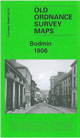
Bodmin 1906
Bodmin in 1906 in a fascinating series of reproductions of old Ordnance Survey plans in the Alan Godfrey Editions, ideal for anyone interested in the history of their neighbourhood or family. Selected towns in Great Britain and Ireland are covered by maps showing the extent of urban development in the last decades of the 19th and early 20th century.In this title: this detailed map covers most of Bodmin, once the county town of Cornwall. Coverage stretches from the Asylum eastward to Love Lane, including all the town centre. Features include Bodmin & Wadebridge Railway with terminus, St Petrock's church, Fore Street area, Bore Street area, County Lunatic Asylum, Bodmin Workhouse, part of Bodiniel (in top left corner), etc. On the reverse is a list of private residents from a 1910
directory. About the Alan Godfrey Editions of the 25
directory. About the Alan Godfrey Editions of the 25
Product Description
Reviews/Comments
Add New
Intelligent Comparison
Archived Product
Bodmin 1906 Stanfords
£3.50
Vouchers
No voucher codes found.
Do you know a voucher code for this product or supplier? Add it to Insights for others to use.
Do you know a voucher code for this product or supplier? Add it to Insights for others to use.
 Denmark