
 United Kingdom
 France
 Germany
 Netherlands
 Sweden
 USA
USA
 Italy
Italy
 Spain
Spain
More From Contributor


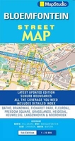
Bloemfontein
Indexed street map of Bloemfontein and suburbs, with an inset enlargement of the town centre and a road map of the Free State on the reverse. The city coverage extends from Bainsvlai in the north-west to Grasland in the east and JB Mafora district in the south. Detail includes one-way streets, traffic lights, service stations, railways and car parks. District names are indicated and colour coding distinguishes land use e.g. industrial, built-up, retail district, parks. A further range of symbols depict places of interest, landmarks, museums, tourist information offices, shopping centres, various community services, churches, hospitals, sports facilities etc. Latitude and longitude lines are drawn at 1’ intervals. An inset at 1:15, 000 shows the central area with greater
clarity. The map is indexed for streets.On the reverse is a road map of Free State at 1:800, 000. Road detail includes secondary roads and toll routes, distinguishes untarred roads and shows intermediate distances on many routes. Other detail includes provincial boundaries, airports, historic sites, battlefields, reserves and other places of interest. Latitude and longitude lines are drawn at 30’ intervals. Indexed for place names.
clarity. The map is indexed for streets.On the reverse is a road map of Free State at 1:800, 000. Road detail includes secondary roads and toll routes, distinguishes untarred roads and shows intermediate distances on many routes. Other detail includes provincial boundaries, airports, historic sites, battlefields, reserves and other places of interest. Latitude and longitude lines are drawn at 30’ intervals. Indexed for place names.

Product Description
Reviews/Comments
Add New
Vouchers
No voucher codes found.
Do you know a voucher code for this product or supplier? Add it to Insights for others to use.
Do you know a voucher code for this product or supplier? Add it to Insights for others to use.
 Denmark