More From Contributor
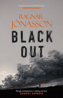
£2.95
Blackhill & Shotley Bridge in 1895 in a fascinating series of reproductions of old Ordnance Survey plans in the Alan Godfrey Editions, ideal for anyone interested in the history of their neighbourhood or family. Selected towns in Great Britain & Ireland are covered by maps showing the extent of urban development in the last decades of the 19th & early 20th century. In this title: the map is double-sided. The main map covers Blackhill, stretching from Cutlers Hall Road & Bridge Hill eastward to Medomsley Road; & from Consett Park & the northern tip of the Consett Iron Works northward to Benfieldside. The centre of Shotley Bridge, by the river, is in the extreme north-west corner. Features include the station, St Cuthbert's church, Benfieldside House, Benfieldside Cemetery, Durham Road, No 1 Farm, hosiery factory. On the reverse is a large section of adjacent sheet 11.06 taking coverage further north & this

Includes::
much of Shotley Bridge with Shotley Bridge station, Whinny House, Snow's Green, Shotley Park, Shotley House & Shotley Bridge Spa. About the Alan Godfrey Editions of the 25

...
Archived Product
£3.50
Blackhill & Shotley Bridge in 1895 in a fascinating series of reproductions of old Ordnance Survey plans in the Alan Godfrey Editions, ideal for anyone interested in the history of their neighbourhood or family. The map is double-sided. The main map covers Blackhill, stretching from Cutlers Hall Road & Bridge Hill eastward to Medomsley Road; & from Consett Park & the northern tip of the Consett Iron Works northward to Benfieldside. The centre of Shotley Bridge, by the river, is in the extreme north-west corner. Features include the station, St Cuthbert`s church, Benfieldside House, Benfieldside Cemetery, Durham Road, No 1 Farm, hosiery factory, etc. On the reverse is a large section of adjacent sheet 11.06 taking coverage further north & this

Includes::
much of Shotley Bridge with Shotley Bridge station, Whinny House, Snow`s Green, Shotley Park, Shotley House & Shotley Bridge Spa. About the Alan Godfrey Editions of the 25” OS Series: Selected towns in Great Britain & Ireland are covered by maps showing the extent of urban development in the last decades of the 19th & early 20th century. The plans have been taken from the Ordnance Survey mapping & reprinted at about 15 inches to one mile (1:4, 340). On the reverse most maps have historical notes & many also include extracts from contemporary directories. Most maps cover about one mile (1.6kms) north/south, one & a half miles (2.4kms) across; adjoining sheets can be combined to provide wider coverage.FOR MORE INFORMATION & A COMPLETE LIST OF ALL AVAILABLE TITLES PLEASE CLICK ON THE SERIES LINK.

...
Archived Product
£7.99
A brutal killing takes place on the Isle of Lewis, Scotland: a land of harsh beauty & inhabitants of deep-rooted faith. A MURDER. Detective Inspector Fin Macleod is sent from Edinburgh to investigate. For Lewis-born Macleod, the case represents a journey both home & into his past. A SECRET. Something lurks within the close-knit island community. Something sinister. A TRAP. As Fin investigates, old skeletons begin to surface, & soon he, the hunter, becomes the hunted. ...
Archived Product
£3.50
Blackley & Lower Crumpsall in 1915 in a fascinating series of reproductions of old Ordnance Survey plans in the Alan Godfrey Editions, ideal for anyone interested in the history of their neighbourhood or family. The map covers a busy area of north Manchester which

Includes::
Blackley, Lower Crumpsall, Barnes Green, the northern part of Harpurhey & the western part of Moston. The Rochdale Road runs north-south through the map. Coverage stretches from Crumpsall Park eastward to Herbert Street & Bute Street; & from Ringley Street (Harpurhey) northward to Oakworth Street (Blackley). Features include at Charlestown
- Booth Hall Infirmary & Boggart Hole Clough; at Blackley
- St Peter`s church, Market Street, Central Mills, Blackley Mill at Blackley Vale Mill; at
- Crumpsall Crumpsall Vale Chemical Works, Delaunay`s Road Institution, Crescent Road Institution, Jews Cemetery & Crumpsall Mills; at Harpurhey
- Christ Church, Scotch Finishing & Raising Works, public baths, etc. On the reverse are street directories for Charlestown Road, Delaunay`s Road, Lion Street, Market Street, Old Road, Rochdale Road & Westbury Road. About the Alan Godfrey Editions of the 25” OS Series: Selected towns in Great Britain & Ireland are covered by maps showing the extent of urban development in the last decades of the 19th & early 20th century. The plans have been taken from the Ordnance Survey mapping & reprinted at about 15 inches to one mile (1:4, 340). On the reverse most maps have historical notes & many also include extracts from contemporary directories. Most maps cover about one mile (1.6kms) north/south, one & a half miles (2.4kms) across; adjoining sheets can be combined to provide wider coverage.FOR MORE INFORMATION & A COMPLETE LIST OF ALL AVAILABLE TITLES PLEASE CLICK ON THE SERIES LINK.


...
Archived Product
£8.99
Bologna in August. Unbearable heat, an empty city. Claudia is a young student in a hurry to return home from her work as a waitress & get out of the uniform she hates. Tomas is a young man on his way to elope with his girlfriend Francesca & rescue her from her dysfunctional family. Aldo is a husband & father with an uncanny resemblance to Elvis Presley, anxious to get to an apartment filled with guilty secrets. All three have an urgent need to be somewhere else. Instead, they are trapped in a lift in a deserted building on a holiday weekend...and one of the trio is a serial killer. This dark, twist-packed psychological thriller has been adapted as a film by Mexican director, Rigoberto Castaneda, who made last year`s Mexican/ Spanish co-production ” Kilometro 31”, screened at the London Film Festival. ...
Archived Product
£14.99
Blackpool, Preston, Lytham St Anne`s & Leyland area on a detailed topographic & GPS compatible map No. 286, waterproof version, from the Ordnance Survey’s 1:25, 000 Explorer series.MOBILE DOWNLOADS: this title & all the other OS Explorer maps include a code for downloading after purchase the digital version onto your smartphone or tablet for viewing on the OS smartphone app.OS EXPLORER SERIES: to see the list of all the titles in the OS Explorer series, both paper & waterproof versions, please click on the series link. The Explorer series, Ordnance Survey’s most detailed maps recommended for anyone enjoying outdoor activities, provides topographic coverage of Great Britain at 1:25, 000 on GPS compatible maps with hiking trails, cycling routes & extensive tourist information. Each printed map is available either on paper or as a waterproof & tear-resistant OS Active Map, as indicated in its title. Britain’s National Parks & other areas of particular tourist interest are presented on often double-sided OL (Outdoor Leisure) maps, whilst most standard format Explorers cover an area of 30 x 20km (approx. 19 x 12 miles). All three versions (paper, waterproof & digital) are the same & provide plenty of recreational & tourist information, indicating the traditional public right of way paths (except in Scotland where different laws apply), including bridleways & byways. National Trails & other long-distance paths are marked, as well as permissive footpaths or bridleways & on-road or traffic-free cycle routes with, where appropriate, their National/ Regional Cycle Network numbers. Boundaries of access land are clearly marked. A wide range of symbols provides additional tourist information, highlighting camping & caravanning sites, information offices & visitors’ centres, parking & picnicking places, country pubs, sport & recreational facilities including cycle hire locations & mountain biking trails, historic buildings & museums, etc. Exceptionally clear presentation of the landscape is provided by contours at 5m or in the uplands at 10m intervals, with additional spot heights plus colouring and/or graphics for different types of woodlands, orchards, heath, marshl&, scree or boulders, & other topographic features. For GPS users the maps have British National Grid lines at 1km intervals, with latitude & longitude given by margin ticks at 1`. Clearly laid out map legend

Includes::
French & German translations for the tourist information symbols.

...
Archived Product
£8.99
Blackpool, Preston, Lytham St Anne`s & Leyland area on a detailed topographic & GPS compatible map No. 286, paper version, from the Ordnance Survey’s 1:25, 000 Explorer series.MOBILE DOWNLOADS: this title & all the other OS Explorer maps include a code for downloading after purchase the digital version onto your smartphone or tablet for viewing on the OS smartphone app.OS EXPLORER SERIES: to see the list of all the titles in the OS Explorer series, both paper & waterproof versions, please click on the series link. The Explorer series, Ordnance Survey’s most detailed maps recommended for anyone enjoying outdoor activities, provides topographic coverage of Great Britain at 1:25, 000 on GPS compatible maps with hiking trails, cycling routes & extensive tourist information. Each printed map is available either on paper or as a waterproof & tear-resistant OS Active Map, as indicated in its title. Britain’s National Parks & other areas of particular tourist interest are presented on often double-sided OL (Outdoor Leisure) maps, whilst most standard format Explorers cover an area of 30 x 20km (approx. 19 x 12 miles). All three versions (paper, waterproof & digital) are the same & provide plenty of recreational & tourist information, indicating the traditional public right of way paths (except in Scotland where different laws apply), including bridleways & byways. National Trails & other long-distance paths are marked, as well as permissive footpaths or bridleways & on-road or traffic-free cycle routes with, where appropriate, their National/ Regional Cycle Network numbers. Boundaries of access land are clearly marked. A wide range of symbols provides additional tourist information, highlighting camping & caravanning sites, information offices & visitors’ centres, parking & picnicking places, country pubs, sport & recreational facilities including cycle hire locations & mountain biking trails, historic buildings & museums, etc. Exceptionally clear presentation of the landscape is provided by contours at 5m or in the uplands at 10m intervals, with additional spot heights plus colouring and/or graphics for different types of woodlands, orchards, heath, marshl&, scree or boulders, & other topographic features. For GPS users the maps have British National Grid lines at 1km intervals, with latitude & longitude given by margin ticks at 1`. Clearly laid out map legend

Includes::
French & German translations for the tourist information symbols.

...
Archived Product
£6.39
A detailed topographic map of Blackpool & Preston from the Ordnance Survey Explorer series, covering Lytham St Anne's & Leyl&. Edition A1, 2nd reprint with minor changes; publication date September 2008 About this series: These highly detailed maps show all the administrative boundaries, settlements as small as isolated farms, the road network down to unfenced roads & country tracks, & field boundaries (hedges & drystone walls) which make navigation across the countryside much easier. Steep gradients on roads are indicated. Various landmarks, e.g. powerlines, archaeological sites, windmills, churches & lighthouses are shown & additional graphics indicate natural terrain features such as cliffs, scree, mud & vegetation variations. The contour interval is 5 metres in the lower parts of the country & 10 metres in the uplands, & spot heights are marked. Each map covers an area of 30 x 20km (i.e. approx. 19 x 12 miles), with some double-sided maps covering more, as indicated in the individual descriptions. The maps are fully GPS compatible, with the National Grid shown at 1km intervals & latitude & longitude indicated by margin ticks at 1'. The Explorer series has replaced the earlier, green-cover Pathfinder maps. The Explorer series is now complete & covers all of Engl&, Wales & Scotl&. Some sheets for popular areas like the National Parks are still branded as Outdoor Leisure (OL) maps, but are now included in this series as the cartography is the same as that in the Explorer Maps. The Explorer maps offer a substantial improvement on the Pathfinder series, with greater use of colour, larger area per map, & stronger emphasis on information for ramblers & tourists. This series is ideal for walking & other outdoor pursuits & each map shows a large amount of information for ramblers & tourists. Public rights of way are shown (except in Scotland), together with other routes with public access: National Trails & Recreational Paths, permitted paths & bridleways, & selected cycle routes. Open access land created under the Countryside & Rights of Way Act 2000 is marked. Tourist information

Includes::
caravan & camp sites, Park & Ride locations, recreation/leisure/sport centres, museums, historic buildings, English Heritage & National Trust sites, rural pubs, etc. The map legend is in English only, except for the tourist information content which is also in French & German.

...
Archived Product
£11.19
Laminated waterproof edition of a detailed topographic map of Blackpool & Preston from the Ordnance Survey Explorer series, covering Lytham St Anne's & Leyl&. Edition A1
- 2nd reprint with minor changes; Publication date September 2008 About this series: These highly detailed maps show all the administrative boundaries, settlements as small as isolated farms, the road network down to unfenced roads & country tracks, & field boundaries (hedges & drystone walls) which make navigation across the countryside much easier. Steep gradients on roads are indicated. Various landmarks, e.g. powerlines, archaeological sites, windmills, churches & lighthouses are shown & additional graphics indicate natural terrain features such as cliffs, scree, mud & vegetation variations. The contour interval is 5 metres in the lower parts of the country & 10 metres in the uplands, & spot heights are marked. Each map covers an area of 30 x 20km (i.e. approx. 19 x 12 miles), with some double-sided maps covering more, as indicated in the individual descriptions. The maps are fully GPS compatible, with the National Grid shown at 1km intervals & latitude & longitude indicated by margin ticks at 1'. The Explorer series has replaced the earlier, green-cover Pathfinder maps. The Explorer series is now complete & covers all of Engl&, Wales & Scotl&. Some sheets for popular areas like the National Parks are still branded as Outdoor Leisure (OL) maps, but are now included in this series as the cartography is the same as that in the Explorer Maps. The Explorer maps offer a substantial improvement on the Pathfinder series, with greater use of colour, larger area per map, & stronger emphasis on information for ramblers & tourists. This series is ideal for walking & other outdoor pursuits & each map shows a large amount of information for ramblers & tourists. Public rights of way are shown (except in Scotland), together with other routes with public access: National Trails & Recreational Paths, permitted paths & bridleways, & selected cycle routes. Open access land created under the Countryside & Rights of Way Act 2000 is marked. Tourist information

Includes::
caravan & camp sites, Park & Ride locations, recreation/leisure/sport centres, museums, historic buildings, English Heritage & National Trust sites, rural pubs, etc. The map legend is in English only, except for the tourist information content which is also in French & German.


...
Archived Product
£2.95
 Blackpool Central Pier in 1909 in a fascinating series of reproductions of old Ordnance Survey plans in the Alan Godfrey Editions, ideal for anyone interested in the history of their neighbourhood or family. Selected towns in Great Britain & Ireland are covered by maps showing the extent of urban development in the last decades of the 19th & early 20th century. In this title: the map covers the area of Blackpool around the Central Pier & Golden Mile. Features include most of Central station & the railway approaches, including engine depot; Bloomfield Road football ground, gasworks, tram depot, Central Drive, promenade south to Shaw Road, Revoe, Central Pier. On the reverse are street directories for Alexandra Road, Central Drive, Promenade (South) in 1934. About the Alan Godfrey Editions of the 25 ...
Archived Product

Blackout

On the shores of a tranquil fjord in Northern Iceland, a man is brutally beaten to death on a bright summer`s night. As the 24-hour light of the arctic summer is transformed into darkness by an ash cloud from a recent volcanic eruption, a young reporter leaves Reykajvik to investigate on her own, unaware that an innocent person`s life hangs in the balance.Ari Thor Arason and his colleagues on the tiny police force in Siglufjordur struggle with an increasingly perplexing case, while their own serious personal problems push them to the limit. What secrets does the dead man harbour, and what is the young reporter hiding? As silent, unspoken horrors from the past threaten them all, and the darkness deepens, it`s a race against time to find the killer before someone else dies...Dark,
terrifying and complex, Blackout is an exceptional, atmospheric thriller from one of Iceland`s finest crime writers.
RIP - This product is no longer available on our network. It was last seen on 25.09.2019

This page now acts as a permanent archive for this product. Add more information using the comments box below to ensure it can still be found by future generations.

Use our search facility to see if it is available from an alternative contributor.
  • External links may include paid for promotion
  • Availability: Out Of Stock
  • Supplier: Stanfords
  • SKU: 9781910633465
Availability: In Stock
£8.99

Product Description

On the shores of a tranquil fjord in Northern Icel&, a man is brutally beaten to death on a bright summer`s night. As the 24-hour light of the arctic summer is transformed into darkness by an ash cloud from a recent volcanic eruption, a young reporter leaves Reykajvik to investigate on her own, unaware that an innocent person`s life hangs in the balance. Ari Thor Arason & his colleagues on the tiny police force in Siglufjordur struggle with an increasingly perplexing case, while their own serious personal problems push them to the limit. What secrets does the dead man harbour, & what is the young reporter hiding? As silent, unspoken horrors from the past threaten them all, & the darkness deepens, it`s a race against time to find the killer before someone else dies... Dark, terrifying & complex, Blackout is an exceptional, atmospheric thriller from one of Iceland`s finest crime writers.

Reviews/Comments

Add New

Intelligent Comparison

Oooops!
We couldn't find anything!
Perhaps this product's unique.... Or perhaps we are still looking for comparisons!
Click to bump this page and we'll hurry up.

Price History

Vouchers

No voucher codes found.
Do you know a voucher code for this product or supplier? Add it to Insights for others to use.

Facebook

Jargon Buster

Hour - A measurement of time, 60 minutes is equal to one hour
Summer - The season between Spring and Autumn. Usually the hottest season of the year
police - Persons empowered to reduce civil disorder and enforce the law.
Dark - A colour which absorbs visable ligt so apears less light than objects that reflect light
Exceptional - Something that is very good.
Balance - Something that is evenly weighted to keep something upright.
Personal - Something that belongs more to an individual due to it affecting them more by relating to them.

Supplier Information

Stanfords
Stanfords was established in 1853 and opened their iconic Covent Garden flagship store in 1901. They have become the top retailer of maps, travel books and accessories in the UK and arguably offer the largest selection of maps and travel books worldwide. Famous names such as Captain Robert Falcon Scott, Ranulph Fiennes and Michael Palin have purchased from Stanfords. They now have a shop in Bristol and both stores together with other venues operate a calendar of events including talks, book signings and exhibitions. As a specialist map retailer, the map selection is comprehensive and includes road maps, street maps and walking maps from worldwide destinations, as well as a selection of world atlases and wall maps. Books include travel guides and travel literature. Stanfords also stock globes, from miniatures made of blue marble to magnificent floor-standing globes. The website features a selection of interesting articles on travel topics.
Page Updated: 2023-11-12 20:15:36

Community Generated Product Tags

Oh No! The productWIKI community hasn't generated any tags for this product yet!
Menu