
 United Kingdom
 France
 Germany
 Netherlands
 Sweden
 USA
USA
 Italy
Italy
 Spain
Spain
More From Contributor


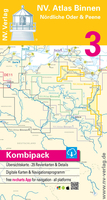
Binnen 3 Nordliche Oder & Die Peene
Rivers Peene and Oder (German and Polish shores) Language: German.Format: Paper, digital raster charts via NV Charts App.A colored set of charts specially designed for inland waterway navigation, spiral bound with charts and details to scale 1: 35.000 (format 40 x 21 cm).Practical to work with, precise information.Detailed charts and a German script with depths, overhead clearance, locks, moorings and points of interest. Danger areas are highlighted in red.

Product Description
Reviews/Comments
Add New
Vouchers
No voucher codes found.
Do you know a voucher code for this product or supplier? Add it to Insights for others to use.
Do you know a voucher code for this product or supplier? Add it to Insights for others to use.
 Denmark