More From Contributor
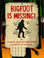
£22.00
Big Walls offers a unique view into a world of extraordinary high adventure, in which fiercely driven climbers scale the highest & most beautiful rock faces on the planet. In this book, renowned climber Paul Piana vividly recounts his & longtime climbing partner Todd Skinner's revolutionary first free-climbing ascents of the four premier rock faces of North America: El Capitan's Salathe Wall, the Direct North West Face of Half Dome, Wyoming's Mount Hooker, & the Great Canadian Knife. Demanding remarkable inner confidence & instincts honed over many years, these free-climbing ascents were accomplished using nothing more than the climbers' own strength & determination. Illustrated with 93 spectacular color photographs of these harrowing ascents, Piana's compelling narrative evokes the dramatic highs & challenging lows of their many adventures, from the heartstopping fall off El Capitan that broke Skinner's ribs & snapped Piana's leg in five places, to their euphoric arrival on the summit of Mount Proboscis. Filled with exciting detail that will appeal to mountaineering enthusiasts everywhere, Big Walls is a fascinating account of four supremely challenging climbs that are truly worthy of the term historic. ...
Archived Product
£20.00
` James Holland is a master` BBC History It was to be the battle to end the air war once & for all... During the third week of February 1944, the combined Allied air forces based in Britain & Italy launched their first-ever round-the-clock bomber offensive against Germany. The aim was to smash the main factories & production centres of the Luftwaffe & at the same time draw the German fighter force up into the air & into battle. Officially called Operation ARGUMENT, this monumental air assault was very quickly became known simply as Big Week. In the six months up to its launch, for the Allies, the bomber war was not turning out as planned. Raids by the US Eighth Air Force & the RAF deep into Germany were being decimated & falling far short of its purpose. With D-Day drawing ever-closer, that was a massive problem. The Allies needed clear skies to invade. The clock was ticking inexorably. Yet the Luftwaffe was also in crisis. Short of resources, of fuel, & on properly trained pilots, the strain on those still flying was immense, their losses severe. & despite the chaos of their leadership, they were achieving far more than should have been reasonably expected against the superior numbers of the Allied planes. Big Week is the knife-edged story of bomber against flak gun & fighter, but also, crucially, fighter against fighter, as the stakes rose higher & higher. Following the fortunes of pilots, aircrew & civilians from both sides, this is a blistering narrative of one of the most critical periods of the entire war, one that culminated in the largest air battle ever witnessed. It is also one that has been largely forgotten, but which has been brilliantly brought back to life by award-winning historian, James Holl&. ...
Archived Product
£7.99
Each year, hundreds of people set out across North America determined to set a new record in a spectacularly competitive event. Is it tennis? Golf? Racing? Poker perhaps? No, it`s bird-watching, & a contest known as the Big Year
- a gr&, gruelling, expensive (and occasionally vicious) 365-day marathon to identify the most species. The ” Big Year” is the rollicking chronicle of the 275, 000-mile odyssey of three unlikely adventurers who take their bird-watching so seriously it nearly kills them. From Texas in pursuit of the Rufus-capped Warbler to British Columbia in search of Xantus` Hummingbird, these obsessive enthusiasts brave roasting deserts, storm-tossed oceans, infested swamps & disgruntled lions (not to mention some of the lumpiest hotel mattresses known to man) as they vie to become North America`s number one bird-watcher in what would prove to be the biggest Big Year of them all... This captivating tour of human & avian nature, of courage & deceit, of passion & paranoia reveals the extremes to which Man will go to pursue his dreams, to conquer & to categorize...
...
Archived Product
£2.99
Bigbury, Avon & Erme area of southern Devon on a very detailed, GPS compatible hiking, cycling & horse riding map from Croydecycle at 1:12, 500, printed on light, waterproof & tear-resistant synthetic paper. The map is part of publishers’ series covering the western coast of Somerset, both coastlines of Devon, & the adjoining areas of Dorset. Each handy size, 50 x 35cm, map is double-sided to cover a wider area. Topography is indicated by contours at 10m intervals with graphics and/or colouring for different type of terrain (s&, shingle, mud, high or low cliffs, etc) & vegetation (woodlands, gorse, scrub, etc). An overprint highlights footpaths, permissive paths & small permissive paths, Bridleways, cycle tracks & country roads which are byways for all traffic. On other roads markings indicate routes which are part of the National Cycle Network. Symbols show locations of campsites & caravan sites, riding stables, pubs/cafes/restaurants, shops & other local facilities, etc. For GPS users each map has in the margins National Grid coordinates. Most 1:12, 500 maps include enlargements of main town (s), an inset providing geological information, & details of transport options. To see other titles in this series, including cycle maps, please click on the series link. The 1:12, 500 maps are numbered on our website westwards along the Somerset & north Devon coast, & then eastwards along the southern coast of Devon & into Dorset. ...
Archived Product
£23.99
Map No. 10056, Bigdin, in the new topographic survey of Norway at 1:50, 000 covering the country on 195 double-sided sheets & first published by Nordeca in 2011
- 2012; fully GPS compatible, indicating waymarked footpaths, campsites, tourist huts, illuminated ski runs, etc. The maps, now published by Nordeca, the successors to Statens Kartverk & its subsequent owners the Ugland Group, are printed on light, waterproof & tear-resistant synthetic paper. Each map covers an area of 62x 45 kilometres (39 x 28 miles approx.), with a 2-km overlap between the sheets. The maps have contours at 20m intervals (10m glacier contours), plus colouring & graphics to show cultivated areas, bogs, forests, etc. In addition to all the information expected of topographic mapping at this scale the maps distinguish between waymarked & unmarked footpaths & show campsites, tourist huts (serviced/self service/no supplies), country hotels & restaurants, & illuminated ski trails. The series uses EUREF89 (WGS84) datum & the maps have a 1-km UTM grid. Map legend is in Norwegian & English. Each title comes in a sturdy protective card envelope.
...
Archived Product
£6.39
A detailed topographic map of Biggar & Broughton from the Ordnance Survey Explorer series, covering Culter Fell & Dollar Law. Edition A1; Publication date November 2006 About this series: These highly detailed maps show all the administrative boundaries, settlements as small as isolated farms, the road network down to unfenced roads & country tracks, & field boundaries (hedges & drystone walls) which make navigation across the countryside much easier. Steep gradients on roads are indicated. Various landmarks, e.g. powerlines, archaeological sites, windmills, churches & lighthouses are shown & additional graphics indicate natural terrain features such as cliffs, scree, mud & vegetation variations. The contour interval is 5 metres in the lower parts of the country & 10 metres in the uplands, & spot heights are marked. Each map covers an area of 30 x 20km (i.e. approx. 19 x 12 miles), with some double-sided maps covering more, as indicated in the individual descriptions. The maps are fully GPS compatible, with the National Grid shown at 1km intervals & latitude & longitude indicated by margin ticks at 1'. The Explorer series has replaced the earlier, green-cover Pathfinder maps. The Explorer series is now complete & covers all of Engl&, Wales & Scotl&. Some sheets for popular areas like the National Parks are still branded as Outdoor Leisure (OL) maps, but are now included in this series as the cartography is the same as that in the Explorer Maps. The Explorer maps offer a substantial improvement on the Pathfinder series, with greater use of colour, larger area per map, & stronger emphasis on information for ramblers & tourists. This series is ideal for walking & other outdoor pursuits & each map shows a large amount of information for ramblers & tourists. Public rights of way are shown (except in Scotland), together with other routes with public access: National Trails & Recreational Paths, permitted paths & bridleways, & selected cycle routes. Open access land created under the Countryside & Rights of Way Act 2000 is marked. Tourist information

Includes::
caravan & camp sites, Park & Ride locations, recreation/leisure/sport centres, museums, historic buildings, English Heritage & National Trust sites, rural pubs, etc. The map legend is in English only, except for the tourist information content which is also in French & German.

...
Archived Product
£14.99
Biggar, Broughton, Culter Fell & Dollar Law area on a detailed topographic & GPS compatible map No. 336, waterproof version, from the Ordnance Survey’s 1:25, 000 Explorer series.MOBILE DOWNLOADS: this title & all the other OS Explorer maps include a code for downloading after purchase the digital version onto your smartphone or tablet for viewing on the OS smartphone app.OS EXPLORER SERIES: to see the list of all the titles in the OS Explorer series, both paper & waterproof versions, please click on the series link. The Explorer series, Ordnance Survey’s most detailed maps recommended for anyone enjoying outdoor activities, provides topographic coverage of Great Britain at 1:25, 000 on GPS compatible maps with hiking trails, cycling routes & extensive tourist information. Each printed map is available either on paper or as a waterproof & tear-resistant OS Active Map, as indicated in its title. Britain’s National Parks & other areas of particular tourist interest are presented on often double-sided OL (Outdoor Leisure) maps, whilst most standard format Explorers cover an area of 30 x 20km (approx. 19 x 12 miles). All three versions (paper, waterproof & digital) are the same & provide plenty of recreational & tourist information, indicating the traditional public right of way paths (except in Scotland where different laws apply), including bridleways & byways. National Trails & other long-distance paths are marked, as well as permissive footpaths or bridleways & on-road or traffic-free cycle routes with, where appropriate, their National/ Regional Cycle Network numbers. Boundaries of access land are clearly marked. A wide range of symbols provides additional tourist information, highlighting camping & caravanning sites, information offices & visitors’ centres, parking & picnicking places, country pubs, sport & recreational facilities including cycle hire locations & mountain biking trails, historic buildings & museums, etc. Exceptionally clear presentation of the landscape is provided by contours at 5m or in the uplands at 10m intervals, with additional spot heights plus colouring and/or graphics for different types of woodlands, orchards, heath, marshl&, scree or boulders, & other topographic features. For GPS users the maps have British National Grid lines at 1km intervals, with latitude & longitude given by margin ticks at 1`. Clearly laid out map legend

Includes::
French & German translations for the tourist information symbols.

...
Archived Product
£8.99
Biggar, Broughton, Culter Fell & Dollar Law area on a detailed topographic & GPS compatible map No. 336, paper version, from the Ordnance Survey’s 1:25, 000 Explorer series.MOBILE DOWNLOADS: this title & all the other OS Explorer maps include a code for downloading after purchase the digital version onto your smartphone or tablet for viewing on the OS smartphone app.OS EXPLORER SERIES: to see the list of all the titles in the OS Explorer series, both paper & waterproof versions, please click on the series link. The Explorer series, Ordnance Survey’s most detailed maps recommended for anyone enjoying outdoor activities, provides topographic coverage of Great Britain at 1:25, 000 on GPS compatible maps with hiking trails, cycling routes & extensive tourist information. Each printed map is available either on paper or as a waterproof & tear-resistant OS Active Map, as indicated in its title. Britain’s National Parks & other areas of particular tourist interest are presented on often double-sided OL (Outdoor Leisure) maps, whilst most standard format Explorers cover an area of 30 x 20km (approx. 19 x 12 miles). All three versions (paper, waterproof & digital) are the same & provide plenty of recreational & tourist information, indicating the traditional public right of way paths (except in Scotland where different laws apply), including bridleways & byways. National Trails & other long-distance paths are marked, as well as permissive footpaths or bridleways & on-road or traffic-free cycle routes with, where appropriate, their National/ Regional Cycle Network numbers. Boundaries of access land are clearly marked. A wide range of symbols provides additional tourist information, highlighting camping & caravanning sites, information offices & visitors’ centres, parking & picnicking places, country pubs, sport & recreational facilities including cycle hire locations & mountain biking trails, historic buildings & museums, etc. Exceptionally clear presentation of the landscape is provided by contours at 5m or in the uplands at 10m intervals, with additional spot heights plus colouring and/or graphics for different types of woodlands, orchards, heath, marshl&, scree or boulders, & other topographic features. For GPS users the maps have British National Grid lines at 1km intervals, with latitude & longitude given by margin ticks at 1`. Clearly laid out map legend

Includes::
French & German translations for the tourist information symbols.

...
Archived Product
£11.19
Laminated waterproof edition of a detailed topographic map of Biggar & Broughton from the Ordnance Survey Explorer series, covering Culter Fell & Dollar Law. Edition A1; Publication date November 2006 About this series: These highly detailed maps show all the administrative boundaries, settlements as small as isolated farms, the road network down to unfenced roads & country tracks, & field boundaries (hedges & drystone walls) which make navigation across the countryside much easier. Steep gradients on roads are indicated. Various landmarks, e.g. powerlines, archaeological sites, windmills, churches & lighthouses are shown & additional graphics indicate natural terrain features such as cliffs, scree, mud & vegetation variations. The contour interval is 5 metres in the lower parts of the country & 10 metres in the uplands, & spot heights are marked. Each map covers an area of 30 x 20km (i.e. approx. 19 x 12 miles), with some double-sided maps covering more, as indicated in the individual descriptions. The maps are fully GPS compatible, with the National Grid shown at 1km intervals & latitude & longitude indicated by margin ticks at 1'. The Explorer series has replaced the earlier, green-cover Pathfinder maps. The Explorer series is now complete & covers all of Engl&, Wales & Scotl&. Some sheets for popular areas like the National Parks are still branded as Outdoor Leisure (OL) maps, but are now included in this series as the cartography is the same as that in the Explorer Maps. The Explorer maps offer a substantial improvement on the Pathfinder series, with greater use of colour, larger area per map, & stronger emphasis on information for ramblers & tourists. This series is ideal for walking & other outdoor pursuits & each map shows a large amount of information for ramblers & tourists. Public rights of way are shown (except in Scotland), together with other routes with public access: National Trails & Recreational Paths, permitted paths & bridleways, & selected cycle routes. Open access land created under the Countryside & Rights of Way Act 2000 is marked. Tourist information

Includes::
caravan & camp sites, Park & Ride locations, recreation/leisure/sport centres, museums, historic buildings, English Heritage & National Trust sites, rural pubs, etc. The map legend is in English only, except for the tourist information content which is also in French & German.

...
Archived Product
£3.50
Biggleswade in 1924 in a fascinating series of reproductions of old Ordnance Survey plans in the Alan Godfrey Editions, ideal for anyone interested in the history of their neighbourhood or family. The map of Biggleswade is double-sided for maximum coverage. The main map shows the northern part of the town &

Includes::
St John`s Church, St Andrews Church, Cemetery, Town Hall, Market Place, High Street, Railway Line, St John`s Street & Fairfield Road. On the reverse is part of the sheet to the south of the main map which shows the Station, Picture Theatre, Boddington House, Holme Grove & Holme Court, Motor Body Works & Brook House. About the Alan Godfrey Editions of the 25” OS Series: Selected towns in Great Britain & Ireland are covered by maps showing the extent of urban development in the last decades of the 19th & early 20th century. The plans have been taken from the Ordnance Survey mapping & reprinted at about 15 inches to one mile (1:4, 340). On the reverse most maps have historical notes & many also include extracts from contemporary directories. Most maps cover about one mile (1.6kms) north/south, one & a half miles (2.4kms) across; adjoining sheets can be combined to provide wider coverage.FOR MORE INFORMATION & A COMPLETE LIST OF ALL AVAILABLE TITLES PLEASE CLICK ON THE SERIES LINK.

...
Archived Product

Bigfoot Is Missing

Children`s Poets Laureate J. Patrick Lewis and Kenn Nesbitt team up to offer a smart, stealthy tour of the creatures of shadowy myth and fearsome legend—the enticing, the humorous and the strange. Bigfoot, the Mongolian Death Worm and the Loch Ness Monster number among the many creatures lurking within these pages. Readers may have to look twice—the poems in this book are disguised as street signs, newspaper headlines, graffiti, milk cartons and more!
RIP - This product is no longer available on our network. It was last seen on 25.09.2019

This page now acts as a permanent archive for this product. Add more information using the comments box below to ensure it can still be found by future generations.

Use our search facility to see if it is available from an alternative contributor.
  • Availability: Out Of Stock
  • Supplier: Stanfords
  • SKU: 9781452118956
Availability: In Stock
£10.99

Product Description

Children`s Poets Laureate J. Patrick Lewis & Kenn Nesbitt team up to offer a smart, stealthy tour of the creatures of shadowy myth & fearsome legend—the enticing, the humorous & the strange. Bigfoot, the Mongolian Death Worm & the Loch Ness Monster number among the many creatures lurking within these pages. Readers may have to look twice—the poems in this book are disguised as street signs, newspaper headlines, graffiti, milk cartons & more!

Reviews/Comments

Add New

Intelligent Comparison

Oooops!
We couldn't find anything!
Perhaps this product's unique.... Or perhaps we are still looking for comparisons!
Click to bump this page and we'll hurry up.

Price History

Vouchers

No voucher codes found.
Do you know a voucher code for this product or supplier? Add it to Insights for others to use.

Facebook

Jargon Buster

Milk - A dairy product white in colour
team - A group of people or animals linked by a common purpose.
Children - A young life form within the early stages of physical development,

Supplier Information

Stanfords
Stanfords was established in 1853 and opened their iconic Covent Garden flagship store in 1901. They have become the top retailer of maps, travel books and accessories in the UK and arguably offer the largest selection of maps and travel books worldwide. Famous names such as Captain Robert Falcon Scott, Ranulph Fiennes and Michael Palin have purchased from Stanfords. They now have a shop in Bristol and both stores together with other venues operate a calendar of events including talks, book signings and exhibitions. As a specialist map retailer, the map selection is comprehensive and includes road maps, street maps and walking maps from worldwide destinations, as well as a selection of world atlases and wall maps. Books include travel guides and travel literature. Stanfords also stock globes, from miniatures made of blue marble to magnificent floor-standing globes. The website features a selection of interesting articles on travel topics.
Page Updated: 2023-11-12 20:15:36

Community Generated Product Tags

Oh No! The productWIKI community hasn't generated any tags for this product yet!
Menu