More From Contributor
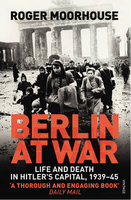
£10.99
Berlin & its Environs on a waterproof, tear-resistant, GPS compatible cycling map at 1:75, 000 from the ADFC (Allgemeiner Deutscher Fahrrad-Club
- the official German cycling federation), in a series of maps with extensive overprint for long-distance & local cycling routes. GPS waypoints, route profiles, details of online links for information about accommodation etc. are also provided. Maps included in this series are contoured & the interval varies according to the type of the terrain. Steep sections are annotated with gradient markings. Colouring and/or graphics show various types of landscape: woods, vineyards, etc. An overprint highlights both the national long-distance cycling routes & the shorter local cycling trails, each clearly identified by a symbol and/or an abbreviation of its name. Sections with heavy traffic and/or poor road surface are clearly marked. Symbols indicate various facilities, such as railway stations with cycle hire, cycle repair shops, campsites, youth hostels, shelters, country restaurants/bars, sport & leisure facilities. Maps have a UTM grid for measuring distances & for determining location using GPS device & they are printed on weather resistant & tear-resistant paper. Each map covers an area of Approx. 87 x 130 km & the map legend is in German only. To see all the titles in this series please click on the series link.
...
Archived Product
£16.95
Map No. 700, Berlin & Environs (4-map set), in a series of hiking maps from Kompass providing extensive coverage of Austria & Germany plus the Slovenian Alps, with hiking routes on a topographic base, various types of accommodation, recreational facilities, places of interest, etc. Many titles are now published as competitively priced sets of two or more maps, offering a wider coverage. Kompass are Europe’s largest publishers of walking maps, with extensive coverage of hiking areas in other countries, all listed on our website. * Cartography:* all the maps are contoured with additional shading & graphic relief to provide a more detailed picture of the terrain, vegetation and/or land use. Contour interval varies from 10 metres in the coastal areas of Northern Germany to 40 or 50 metres in the mountainous parts of the two countries. All the maps highlight local & long-distance waymarked footpaths, including climbing trails. Most titles also show cycling routes, mountain bike trails, &, the in mountainous areas, ski routes. The maps indicate various types of accommodation (selected inns & hotels, youth hostels, campsites, mountain refuges), as well as recreational facilities, places of interest, etc. New editions also show access by public transport with bus stops and/or Park+ Ride facilities.* Geographical coordinates:* unless indicated to the contrary in the individual description, the maps have a UTM grid for GPS users. * Map legend:* most maps now include full English legend, particularly titles covering the Alpine areas. Some maps covering mainly eastern Austria or the less popular parts of Germany may still have a legend in German only.* Other
Features:* some titles now include on the reverse panorama drawings of their area with names of villages, peaks, valleys, etc. and/or have booklets with pictures of local wild flowers with their Latin names.*PLEASE NOTE BEFORE ORDERING!* * Booklets:* many titles come with booklets describing the area and/or various hiking routes. These booklets are in * German only*, apart from a handful of titles where an English language booklet is specifically indicated in the individual description. So, unless English language booklet is actually mentioned, the map can only be supplied with a German booklet. These booklets are not necessary to use the maps since, as stated above, most titles now include * full English language map legend.*
...
Archived Product
£17.50
Berlin & Environs Cycling Atlas from Verlag Esterbauer with 129 tours totaling nearly 1100 kilometres, presented on mapping at 1:20, 000, 1:50, 000 or 1:75.000. The shortest trip is 11km, the longest 120km. Extensive information is conveyed by symbols, indicating road surface, campsites & other accommodation, repair workshops, recreational facilities, places of interest, etc. A list of various types of accommodation facilities is included. Cycling atlases from Verlag Esterbauer have a map legend which

Includes::
English &, although ALL THE TEXT IN THESE GUIDES IS IN GERMAN ONLY, information provided on the maps is sufficient to use them without any knowledge of German, particularly in the absence of similar products in English from other publishers. Please click on our sample image to see an extract from the map legend. Each atlas

Includes::
a selection of local cycling routes & tours, presented on clear, easy to follow maps. The overprint highlighting the routes indicates road surface & density of motorized traffic. Gradients, intermediate distances, danger points, & roads closed to cyclists are marked & route profiles show the degree of difficulty for each cycle path. A wide range of symbols indicate everything from covered & lockable bicycle stands, repair workshops & bike rentals to viewpoints, nature parks, leisure & sport centres, local shopping facilities, emergency services, etc. The guides also give opening hours of museums & other local places of interest. A separate section at the end of each guide list accommodation addresses with phone numbers. To see other titles in this series please click on the series link.


...
Archived Product
£9.99
” Each volume of the Art & Architecture series is opulently illustrated. The highly readable texts provide concentrated information on accessing well-known & less-known sites in the world of art. An image of every piece of art that is described is included, allowing readers to easily recognize the original in situ. Insets on cultural & historical topics & illustrated glossaries, summaries & timelines supplement the body text
- leaving a deeper, more lasting impression of the works discussed.”
...
Archived Product
£6.99
About this series: The Art/ Shop/ Eat guides, from the makers of the popular Blue Guides, are compact city guides with a focus on museums, art galleries & cultural activities, as well as food, drink & entertainment. Each guide is divided into several district sections, & three city-wide sections covering entertainment, trip-planning & an art glossary. District sections each begin with high-scale street maps of the district. Museum & Gallery descriptions form the bulk of each district section, with very detailed entries for the area’s major museums, galleries, churches & historical sites. Entries include practical visitor information, notable holdings, tips for getting the most out of each venue, & background information on both the holdings & the venue itself. Many major entries include floor plans & photographs. The sections are completed with listings of other smaller museums, galleries & sights in the area, commercial galleries & auction houses, selected restaurants & cafés to suit most budgets. Shopping listings cover selected shops for clothes, antiques, books, food & wine, music, art, craftwork & jewellery. The Entertainment listings cover venues for classical music, opera, dance & theatre, as well as music venues, nightclubs & bars & pubs. The trip-planning section

Includes::
general travel information such as flights, transport, formalities & practicalities, & contains selected accommodation listings for most budgets, divided by district. The art glossary lists major artists, sculptors & artistic movements associated with the city, cross-referenced to the museum & gallery listings.

...
Archived Product
£25.00
Berlin was the nerve-centre of Hitler's Germany. It was the backdrop for the most lavish of Nazi ceremonies, the venue for Albert Speer's grandiose plans to forge a new 'world metropolis', & the scene of the final climactic battle to defeat Nazism. Berlin was the stage upon which the rise & fall of the Third Reich was most visibly played out. Yet while our understanding of the Holocaust is well developed, we know little about the wider challenges posed to the German people by living under a dictatorship in wartime, the compromises demanded & the hardships endured. As a result our understanding of everyday life in Nazi Germany is profoundly imbalanced: we know in intimate detail how a minority died under Nazism, but we understand precious little about how the majority lived. In this vivid & important study, Roger Moorhouse seeks to portray the German experience of the Second World War, not through an examination of grand politics, but rather from the viewpoint of the capital's streets & homes
- a ' Berlin-eye view' that makes use of published & unpublished memoirs, diaries & interviews. As well as giving a flavour of everyday life in the German capital, Berlin at War also raises issues about consent & dissent, morality & authority, which go to the heart of the experience of war & dictatorship. Above all, it charts the violent humbling of a once-proud metropolis
- the fear, the cruelty, the petty heroism & the individual tragedy.

...
Archived Product
£8.99
Laminated & waterproof map for visitors to Berlin, combining a plan of the city with an enlargement for the central area, a road map of the environs, & a diagram of public transport network. The main plan at 1:18, 000 extends west to the Olympia stadium & beyond it to the Old Town of Spandau, south to the Tempelhof airport, east to Frankfurter Tor, & north to the port area along the city’s canals. An enlargement at 1:11, 500 presents the Mitte, the city’s historic centre, in greater detail. Coverage extends to include the new Central Station, the Chancellery & the Reichstag, the Kulturforum complex of museums & concert halls, Checkpoint Charlie & Alexander Platz. Both plans show the U-Bahn & S-Bahn stations, tram lines with stops, one way streets & car parks, selected accommodation, places of interest, etc. A list of top 30 sights shows the city’s main places of interest, all highlighted on the plans. On the reverse is a map of the city’s environs within the E55 ring road, including Potsdam & the lakes surrounding Berlin east & west of the city. Both plans & the map are indexed with lists of streets/localities plus main sights & places of interest. Also included is a comprehensive diagram of Berlin’s public transport networks, a map showing the division of the city into the four sectors with the Berlin Wall, an administrative map of Germany, & information of the city’s climate. ...
Archived Product
£12.99
`A city that has lost one of its limbs & is receiving a miraculous gift, a little bump under the flesh, where the limb is just beginning to grow back`. Thus does the American girl in Jeffrey Lewis` remarkable polyphonic novel describe Berlin & the `remnant Jews, secret GDR Jews... Soviet Jews... Jews who`d fled & come back with the victors, Jews who were lost mandarins now, Jews who`d believed in the universality of man & maybe still did` whom she finds at a Day of Atonement gathering in the eastern part of the city in a year soon after the Wall fell. ” Berlin Cantata” deploys thirteen voices to tell a story not only of atonement, but of discovery, loss, identity, intrigue, mystery, insanity, sadomasochism & lies. At its centre is a country house owned successively by Jews, Nazis & Communists. In the country house, the American girl seeks her hidden past. In the girl, a local reporter seeks redemption. In the reporter, a false hero of the past seeks exposure. In the false hero, the American girl seeks a guide. & so it goes, a round of conspiracy & desire. Even as he describes his native city, the false hero describes the characters of ” Berlin Cantata”: ` We dined on wreckage. We were not afraid to beg. We continued our long tradition of believing either in nothing or too much`. ...
Archived Product
£6.95
Double-sided tourist map of Berlin printed on strong waterproof paper folding up in a simple concertina format (10x 24cm). The street plan (1:24, 000), spreading over both sides of the map, shows public transports, tourist information points, car parks, museums, youth hostels, campings, parks & other tourist facilities. The main buildings are illustrated with drawings. Also included is a plan of Berlin's transport system (trains & underground). On the reverse there is also a road map of the city's surroundings, & a clear plan of the road access & car parks in the Berlin-Tegel airport. Finally, the entire length of Kurfurstendamm, the city's main shopping area, is shown with shop & restaurant names & colour-coded for easy reference. On the whole map small insets indicate emergency phone numbers, international dialling codes & other useful local information. The index lists only a selection of streets & the map legend is in four languages including English. Printed on strong laminated paper. ...
Archived Product
£5.50
The Flip Pad is a tried & tested format for notes in all walks of life. Thanks to these new City Flip Pads travellers will find their way around any metropolis as they have a fold out inner city map as well as plenty of space for your notes. All city Flip Pads are bound at the top with a hard cover that flips up to open & folds back for easy note taking. This portable, pocket-sized notepad features a sturdy construction & an elastic fastener to protect sheets on your travels.
- 160 lightly ruled pages
- Portable pocket-size is great for trips
- Personal data page
- Sewn binding
- Elastic band closure
- Fold out city map
- Perforated pages
- Shrink-wrapped


...
Archived Product

Berlin At War

Berlin was the nerve-centre of Hitler`s Germany - the backdrop for the most lavish ceremonies, it was also the venue for Albert Speer`s plans to forge a new `world metropolis` and the scene of the final climactic bid to defeat Nazism. Yet while our understanding of the Holocaust is well developed, we know little about everyday life in Nazi Germany. In this vivid and important study Roger Moorhouse portrays the German experience of the Second World War, not through an examination of grand politics, but from the viewpoint of the capital`s streets and homes.He gives a flavour of life in the capital, raises issues of consent and dissent, morality and authority and, above all, charts the violent humbling of a once-proud metropolis. Shortlisted for the Hessell-Tiltman History Prize.
RIP - This product is no longer available on our network. It was last seen on 25.09.2019

This page now acts as a permanent archive for this product. Add more information using the comments box below to ensure it can still be found by future generations.

Use our search facility to see if it is available from an alternative contributor.
  • External links may include paid for promotion
  • Availability: Out Of Stock
  • Supplier: Stanfords
  • SKU: 9780099551898
Availability: In Stock
£9.99

Product Description

Berlin was the nerve-centre of Hitler`s Germany
- the backdrop for the most lavish ceremonies, it was also the venue for Albert Speer`s plans to forge a new `world metropolis` & the scene of the final climactic bid to defeat Nazism. Yet while our understanding of the Holocaust is well developed, we know little about everyday life in Nazi Germany. In this vivid & important study Roger Moorhouse portrays the German experience of the Second World War, not through an examination of grand politics, but from the viewpoint of the capital`s streets & homes. He gives a flavour of life in the capital, raises issues of consent & dissent, morality & authority &, above all, charts the violent humbling of a once-proud metropolis. Shortlisted for the Hessell-Tiltman History Prize.

Reviews/Comments

Add New

Intelligent Comparison

Oooops!
We couldn't find anything!
Perhaps this product's unique.... Or perhaps we are still looking for comparisons!
Click to bump this page and we'll hurry up.

Price History

Vouchers

No voucher codes found.
Do you know a voucher code for this product or supplier? Add it to Insights for others to use.

Facebook

Jargon Buster

Germany - A country in Central Europe.
History - Anything that happens in the past. An acedemic subject.
World - A physical grouping, commonly used to describe earth and everything associated with ti
Flavour - The taste of a food product.
Experience - To gain further knowledge by practising.

Supplier Information

Stanfords
Stanfords was established in 1853 and opened their iconic Covent Garden flagship store in 1901. They have become the top retailer of maps, travel books and accessories in the UK and arguably offer the largest selection of maps and travel books worldwide. Famous names such as Captain Robert Falcon Scott, Ranulph Fiennes and Michael Palin have purchased from Stanfords. They now have a shop in Bristol and both stores together with other venues operate a calendar of events including talks, book signings and exhibitions. As a specialist map retailer, the map selection is comprehensive and includes road maps, street maps and walking maps from worldwide destinations, as well as a selection of world atlases and wall maps. Books include travel guides and travel literature. Stanfords also stock globes, from miniatures made of blue marble to magnificent floor-standing globes. The website features a selection of interesting articles on travel topics.
Page Updated: 2023-11-12 20:15:36

Community Generated Product Tags

Oh No! The productWIKI community hasn't generated any tags for this product yet!
Menu