More From Contributor
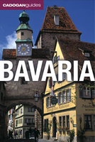
£19.99
Established in 1919 in Weimar, the Bauhaus college for design influenced one of the world`s most important Modernist movements. Divided into three geographic sections that follow the locations of the school-Weimar (1919-25), Dessau (1925-33), & Berlin (1933)-this unique travel guide leads readers through the most important Bauhaus structures in Germany. Each section features important sites that are given historical background. These entries are illustrated with historic & contemporary photography, & are accompanied by up-to-date tourist information. Throughout the book short essays highlight significant events & figures of the Bauhaus movement. This guidebook is an indispensible reference for anyone traveling to Germany`s greatest extant Bauhaus structures. ...
Archived Product
£6.50
Topographic coverage of mainland Spain at 1:25, 000 published by the Centro Nacional de Información Geograficá, the country’s civilian survey organization. The maps have contours at 10m intervals & colouring and/or graphics to show different types of vegetation or land use. Boundaries of national parks & other protected areas are marked. In addition to all the usual information shown on topographic maps at this scale, detailed presentation of the road & rail networks, rural tracks & paths, etc, the maps also show campsites. The maps have a 1-km UTM grid, with margin ticks for latitude & longitude at 1` intervals. Map legend is in Spanish only.PLEASE NOTE: our grid for the whole of Spain is in preparation
- in the meantime, for areas other than those shown on the attached grid please use CNIG’s topographic survey at 1:50, 000 by searching for ‘SI00000832’. Each 25K map covers one quarter of the corresponding 50K map, with the numbering system: I = NW quarter, II = NE quarter, III = SW quarter & IV = SE quarter. CNIG maps in the Provincial Road Maps series at 1:200, 000 are overprinted with the grid for the 1:50, 000 survey & can be used to see the area covered by each 50K or 25K title in more detail. To see the list of titles in this series please click on the series grid
- for map numbers not yet listed on our website please contact us by email.

...
Archived Product
£11.50
Topographic survey of France at 1:25, 000 in IGN`s excellent TOP25 / Série Bleue series. All the maps are GPS compatible, with a 1km UTM grid plus latitude & longitude lines at 5’ intervals. Contours are at 5m intervals except for mountainous areas where the maps have contours at 10m intervals, vividly enhanced by hill shading & graphics for rocky terrain. Colouring with graphics indicates different types of vegetation or land use (deciduous or coniferous forests, moors, orchards, vineyards, etc). PLEASE NOTE: coverage of France at this scale is currently being revised – the format & the presentation of each title are indicated by the letters at the end of its Sheet Reference number (e.g. 0416ET, 3531ETR, 1923SB, etc.)MAPS WITH FULL TOURIST OVERPRINT & AN ENGLISH MAP LEGEND: all TOP25 maps & the SB editions of Série Bleue have an overprint highlighting waymarked walking trails including long-distance GR routes &, where appropriate, ski routes. Symbols indicate campsites, gîtes d’etape, refuges, equestrian centres & other recreational facilities or sites, tourist information centres, cultural heritage, etc. Towns & locations of particular interest are highlighted.- ET or OT = single-sided TOP25 map covering approx. 29x 21 km / 18x 13 miles.- ETR or OTR = waterproof & tear resistant TOP25 map covering the same area as the corresponding ET or OT number, but double-sided, printed on a smaller size sheet with a good overlap between the sides.- SB = Série Bleue map with full tourist overprint; these maps, first introduced in summer 2014, each cover approx. 29x 24km / 18x 15 miles.SÉRIE BLEUE maps with numbers ending in E (Est) or O (Ouest): most editions now indicate the GR routes, but do not show any other tourist information. Map legend is in French only. Each map covers approx. 14x 20km / 9x 12 miles. ...
Archived Product
£12.99
Topographic survey of France at 1:25, 000 in IGN`s excellent TOP25 / Série Bleue series. All the maps are GPS compatible, with a 1km UTM grid plus latitude & longitude lines at 5’ intervals. Contours are at 5m intervals except for mountainous areas where the maps have contours at 10m intervals, vividly enhanced by hill shading & graphics for rocky terrain. Colouring with graphics indicates different types of vegetation or land use (deciduous or coniferous forests, moors, orchards, vineyards, etc). PLEASE NOTE: coverage of France at this scale is currently being revised – the format & the presentation of each title are indicated by the letters at the end of its Sheet Reference number (e.g. 0416ET, 3531ETR, 1923SB, etc.)MAPS WITH FULL TOURIST OVERPRINT & AN ENGLISH MAP LEGEND: all TOP25 maps & the SB editions of Série Bleue have an overprint highlighting waymarked walking trails including long-distance GR routes &, where appropriate, ski routes. Symbols indicate campsites, gîtes d’etape, refuges, equestrian centres & other recreational facilities or sites, tourist information centres, cultural heritage, etc. Towns & locations of particular interest are highlighted.- ET or OT = single-sided TOP25 map covering approx. 29x 21 km / 18x 13 miles.- ETR or OTR = waterproof & tear resistant TOP25 map covering the same area as the corresponding ET or OT number, but double-sided, printed on a smaller size sheet with a good overlap between the sides.- SB = Série Bleue map with full tourist overprint; these maps, first introduced in summer 2014, each cover approx. 29x 24km / 18x 15 miles.SÉRIE BLEUE maps with numbers ending in E (Est) or O (Ouest): most editions now indicate the GR routes, but do not show any other tourist information. Map legend is in French only. Each map covers approx. 14x 20km / 9x 12 miles. ...
Archived Product
£9.99
Sardinia’s eastern coast around & north of the town of Baunei on a detailed, contoured, GPS compatible map at 1:35, 000 from Abies Edizioni, with on the reverse notes on the area’s history, heritage & beaches. Contours are at 20m intervals with colouring for different types of vegetation. The map shows local footpaths & hiking trails, as well as recommended mountain bike routes. Symbols highlight various places of interest including campsites, beaches, diving & surfing sites, viewpoints, climbing sites, nuraghi, churches, etc. The map has a 1-km UTM grid. On the reverse are multilingual notes about the area & its heritage, a list of recommended hiking trails, etc. Map legend & the notes include English. To see the list of all the titles in this series please click on the series link. ...
Archived Product
£15.99
Bavaria & the Austrian Tyrol in the Thomas Cook Driving Guides series; comprising a range of guides dedicated to exploring a selection of the best car tours & drives in Britain, Europe, Australasia & North America. The guides are designed to provide readers with a flexible reference source to explore the region or country by car; taking in the best local attractions & things to do & see. Recommended driving tours are linked with local sights for each chapter & total driving time is indicated clearly. An introductory section gives an overview of the destination with details of the place & its people, history, art & architecture, culture, geography & food & drink. Each chapter is divided into a touring area which is rated in categories such as architecture, entertainment & children to allow readers to plan a drive accordingly. Individual chapters give an outline of the region & provide practical guidance on getting there & around. A dedicated ...
Archived Product
£14.99
Northern Bavaria & north-eastern Baden-Württemberg at 1:125, 000 in a set of two waterproof & tear-resistant, contoured & GPS-compatible cycling maps from Kompass highlighting long-distance, primary & secondary routes, plus accommodation, hire & repair shops, places of interest, etc. Maps in this series have laminated surface which can be annotated with suitable marker pens. Each side of a map covers an area of approx. 121 x 81kms. Topography is shown by contours at 100m intervals with light relief shading, spot heights & colouring/graphics for various types of vegetation or land use. Boundaries of national/natural parks & other protected areas are marked. Colour-coded overprint highlights long-distance, primary & secondary cycling routes & mountain bike trails, each annotated with its waymarking sign or name, moderate or steep gradient markings, plus on long-distance & primary routes intermediate distances. Locations worth visiting are highlighted & symbols indicate accommodation options including campsites & youth hostels, E-bike charging stations, cycle hire & repair outlets, sport & recreational facilities, etc. The maps have 5-km UTM grid. Map legend

Includes::
English. To see the other titles in this series please click on the series link

...
Archived Product
£10.99
One of the titles in a series of large, indexed regional maps with fine, clear cartography. General relief is portrayed by hill-shading with selected spot heights without distracting from the other detail. The motorway network & recommended scenic routes stand out well from the background, but some may find minor local roads a little too faint. In some places exits from motorways are also rather lightly coloured. Intermediate driving distances are indicated throughout & special tourist routes are marked. The maps highlight picturesque towns & national parks, with a range of symbols marking campsites, youth hostels, museums, spas, various landmarks & places of interest, etc. Latitude & longitude grid is drawn at intervals of 10’. Map legend

Includes::
English. A separate index attached to the cover gives the postcode for each locality, including those beyond the German territory on sheets covering border regions.

...
Archived Product
£9.99
Northern Bavaria on an indexed road map at 1:200, 000 in the Mair Dumont’s Marco Polo series, prominently highlighting interesting locations & protected areas. A 111-page index booklet

Includes::
city centre street plans plus enlargements at 1:100, 000 showing in greater detail the environs & road access to Bamberg, Bayreuth, Nuremberg, Regensburg & Würzburg. Also included are plans of the Nuremberg Airport & of the city’s Messe exhibition grounds. Maps in this Mair Dumont Marco Polo series indicate topography by light relief shading & the series is particularly good for identifying geographical

Features:
mountain & hill chains, valleys, national/natural parks, etc. The maps boldly stress main roads & motorways in strong colours & selected towns in large letters, but also show minor roads & villages in considerable detail. Road information

Includes::
toll roads, traffic restrictions & seasonal closures, gradient marking for steep roads, etc. Motorway services clearly indicate types of facilities available there, & driving distances are marked on many small local roads. Scenic roads & special tourist routes are highlighted. Railway network

Includes::
narrow gauge & tourist lines, cable car lines, & chair lifts. Where appropriate, ferry connections are shown. Locations worth visiting, both town/villages & natural sites, are highlighted & graded; 15 best sites are prominently marked & cross-referenced to their descriptions in the accompanying booklet. Other tourist information

Includes::
campsites & youth hostels, landmarks, recreational facilities etc. Latitude & longitude grid is drawn at intervals of 10`. Each title comes with a booklet attached to the map cover containing street plans & maps at 1:100, 000 showing in greater detail road access to main cities. The booklet also provides an index listing towns/villages with their postcodes as well as rivers & landscape features, plus a table with distances/travelling times, & for route planning an overview of the whole area covered by the main map indicating the 15 special places of interest. Map legend & the descriptions include English. To see the list of titles in this series please click on the series link.


...
Archived Product
£9.99
Bavaria at 1:500, 000 on an overview map from Bayerisches Landesvermessungsamt, the state’s official survey organization. The map shows the divisions of the state into regions (Regierungsbezirke) & districts (Kreise). Roads are graded according to their official classification, but are presented without driving distances or numbers/names of interchanges on the autobahns. Railway lines are shown with stations. Topography is shown by shading & graphic relief, plus colouring for woodlands. Boundaries of natural parks are marked. Also shown are restricted entry military training areas. Latitude & longitude lines are shown at intervals in 30’. The map is not indexed. Map legend

Includes::
English.

...
Archived Product

Bavaria

Bavaria in the Cadogan guide series; covering a range of destinations – primarily in Europe - and combining solid research, detailed, practical information and individual points of view on a range of cities, regions and countries. They are particularly strong on historical and cultural sightseeing but also carry a good sense of the particular lifestyle of a destination. Informed itineraries on topics such as architecture, food and drink are included, and the low-down on outdoor activities and cultural events is also provided. Authors have handpicked their own recommendations for places to stay and to eat and drink and an added feature of the series is site and building plans, which are included where relevant to descriptions provided in the accompanying text.Introductions to
Cadogan guides are more sizeable than many other market competitors, containing a profile of the region, history, art and architecture, topical matters, food and drink, planning your trip and an A-Z of practical concerns on tourist information. Each title in the series is organized geographically by region and has a particular focus on cultural and historical sights. Guides conclude with a glossary, language tips and recommendations for further reading.
RIP - This product is no longer available on our network. It was last seen on 25.09.2019

This page now acts as a permanent archive for this product. Add more information using the comments box below to ensure it can still be found by future generations.

Use our search facility to see if it is available from an alternative contributor.
  • External links may include paid for promotion
  • Availability: Out Of Stock
  • Supplier: Stanfords
  • SKU: 9781860114281
Availability: In Stock
£12.99

Product Description

Bavaria in the Cadogan guide series; covering a range of destinations – primarily in Europe
- & combining solid research, detailed, practical information & individual points of view on a range of cities, regions & countries. They are particularly strong on historical & cultural sightseeing but also carry a good sense of the particular lifestyle of a destination. Informed itineraries on topics such as architecture, food & drink are included, & the low-down on outdoor activities & cultural events is also provided. Authors have handpicked their own recommendations for places to stay & to eat & drink & an added feature of the series is site & building plans, which are included where relevant to descriptions provided in the accompanying text. Introductions to Cadogan guides are more sizeable than many other market competitors, containing a profile of the region, history, art & architecture, topical matters, food & drink, planning your trip & an A-Z of practical concerns on tourist information. Each title in the series is organized geographically by region & has a particular focus on cultural & historical sights. Guides conclude with a glossary, language tips & recommendations for further reading.

Reviews/Comments

Add New

Intelligent Comparison

Oooops!
We couldn't find anything!
Perhaps this product's unique.... Or perhaps we are still looking for comparisons!
Click to bump this page and we'll hurry up.

Price History

Vouchers

No voucher codes found.
Do you know a voucher code for this product or supplier? Add it to Insights for others to use.

Facebook

Jargon Buster

strong - A descriptive word for an item that has physical strength
History - Anything that happens in the past. An acedemic subject.
Language - the method of communication used in different areas. Humans and computers have many different languages.
Practical - Weather a task is easy to carry out and realistically succeed.
Solid - Something that is firm and not liquid, a hard shape that cannot be changed easily.
Feature - An attribute that makes something stand out.
Individual - A single separate item or person.
Language - The way humans communicate either written and spoken.

Supplier Information

Stanfords
Stanfords was established in 1853 and opened their iconic Covent Garden flagship store in 1901. They have become the top retailer of maps, travel books and accessories in the UK and arguably offer the largest selection of maps and travel books worldwide. Famous names such as Captain Robert Falcon Scott, Ranulph Fiennes and Michael Palin have purchased from Stanfords. They now have a shop in Bristol and both stores together with other venues operate a calendar of events including talks, book signings and exhibitions. As a specialist map retailer, the map selection is comprehensive and includes road maps, street maps and walking maps from worldwide destinations, as well as a selection of world atlases and wall maps. Books include travel guides and travel literature. Stanfords also stock globes, from miniatures made of blue marble to magnificent floor-standing globes. The website features a selection of interesting articles on travel topics.
Page Updated: 2023-11-12 20:15:36

Community Generated Product Tags

Oh No! The productWIKI community hasn't generated any tags for this product yet!
Menu