More From Contributor
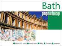
£5.00
The Romans arrived in this green valley nearly two thousand years ago & were captivated by the miraculous stream of endless hot water. The restored bath & temples complex & the splendid Abbey attract thousands of visitors to the city each year. Use this guide to explore today`s Bath where visitors can once more experience the benefits of a dip in the natural mineral water & enjoy a lot more besides
- stylish shops & restaurants, interesting galleries & museums, & the feel of a lively city with its historic past informing an exciting present. It is available in four languages.
...
Archived Product
£9.99
Lurking beneath Bath's genteel spa town facade is a tangle of hidden quirky lives & unusual events. Take Lola Montez, siren, harpy, courtesan, Royal mistress & Spanish dancer, born in County Sligo as Eliza Rosanna Gilbert. Her flamboyant lifestyle & turbulent private life had their roots in her time at a demure finishing school in Bath. Then there's the eerie tale of ' Lady Betty Cobbe's ghost', a bizarre Regency fable surrounding a spirit, a mysterious black ribbon, & accurate premonitions of death. A host of other strange people, such as Dr James Graham, who practised electrotherapy & advocated earth baths, & William Oliver the Viper Catcher, make up Bath's colourful cast of characters. Delving into Bath's peculiar history, Michael Raffael has gathered together a rich collection of stories about these weird individuals & their duels, telescopes, cakes, fizzy drinks, Bath Buns, Sally Lunns & plasticene. The result is a highly readable, eclectic compendium of curiosities that will appeal to Bath residents & visitors alike. ...
Archived Product
£6.99
Bath in the Great Breaks mini series from Insight Guides is a slim, focussed short break guide to the city, whether you are aiming for a relaxing or active break, illustrated with vivid colour photographs & containing easy to navigate information. A top 10 sites for the destination & its surrounding area are given, with a selection of detailed & mapped tour/walk ideas, special features on the uniqueness of the place e.g. its heritage, festivals & wildlife, as well as practical information on active pursuits, themed holidays, & selected places to stay to suit a cross section of budgets & tastes. An overview map showing selected tour routes & a selection of five summary boxes of top five great things to do or places to do adorn the inside jackets. ...
Archived Product
£7.99
Bath in the Great Breaks mini series from Insight Guides is a slim, focussed short break guide to the city, whether you are aiming for a relaxing or active break, illustrated with vivid colour photographs & containing easy to navigate information. A top 10 sites for the destination & its surrounding area are given, with a selection of detailed & mapped tour/walk ideas, special features on the uniqueness of the place e.g. its heritage, festivals & wildlife, as well as practical information on active pursuits, themed holidays, & selected places to stay to suit a cross section of budgets & tastes. An overview map showing selected tour routes & a selection of five summary boxes of top five great things to do or places to do adorn the inside jackets. ...
Archived Product
£12.50
Bath Pevsner Architectual Guide, in a series of publications begun with the express aim of providing up-to-date guides to the most significant buildings in every part of the country, suitable for both general reader & specialist. Each volume provides an introductory overview of the architecture of the area, followed by a descriptive gazetteer arranged alphabetically by place. Whilst cathedrals & their furnishings, great country houses & their parks form the grand set pieces, the books demonstrate the enjoyable diversity of architecture in the British Isles in accounts of rural churches & farmsteads, Victorian public buildings & industrial monuments. A continuing programme of publication keeps the series up-to-date with new information on older buildings & recent architecture while maintaining the tradition of Pevsner's own succinct accounts. Each book has over 100 photographs, mostly specially commissioned, numerous maps & plans, a glossary & indexes. ...
Archived Product
£1.99
Bath Pop Out Map from Compass Maps in a handy format to fit neatly all but the smallest pockets, with, as appropriate, transport network diagrams, additional useful maps, etc. The map's cover flaps open up to reveal a detailed street map of Bath, highlighting numerous sights & cultural institutions, etc. ...
Archived Product
£8.99
Bath to Bournemouth at 1:110 000 scale, clearly mapped traffic free & on road National Cycle Network Routes & linking routes.


...
Archived Product
£4.95
Bath, Bradford-on-Avon & Trowbridge Street Atlas from the Geographers` A-Z Map Company in an A5 paperback format at 1:15, 840 (4” to a mile), with an enlargement showing the town centre of Bath at 1:7, 920 (8” to 1 mile). Coverage

Includes::
Chew Magna, Holt, Keynsham, Midsomer Norton, Paulton, Peasedown St. John, Radstock & Saltford. Current edition of this title was published in 2014. To see other titles in this series of A-Z street atlases of towns & cities please click on the series link. A-Z also publish a series of County Street Atlases, for a list of titles in that series please search for SI00000917.A-Z street atlases present motorways plus A & B roads highlighted by colouring & shown with route numbers. One way or restricted access streets & car parks are marked, as are in more recently published titles locations of speed cameras. Also shown are selected cycleway routes. Where appropriate, A & B roads are annotated with selected house numbers for easier identification of addresses. Railway lines are shown with stations & level crossings. Colouring indicates different types of buildings: educational, hospitals & healthcare, industrial, leisure & recreational, shopping centres & markets, public buildings, & places of interest. Symbols mark locations of facilities usually indicated on street mapping: post offices, emergency services, public toilets, etc. Also marked are postcode & local authority boundaries. Each page has the lines & coordinates of the British National Grid. The indexes list streets, places & areas, hospitals, industrial estates, blocks of flats on housing estates, railway stations, & selected places o interest; the latter are printed in contrasting colouring to make them easier to find.

...
Archived Product
£3.50
Bath, Marshfield & the Vale of Avon in 1912 in a series of reproductions of Ordnance Survey’s famous ” Inch to the Mile” maps published in the Alan Godfrey Editions to provide a historical record of England & Wales in the second half of 19th & early 20th century. The map covers the area around & to the north & east of Bath, stretching from Oldland & Mangotsfield eastward to Chippenham, & from Old Sodbury southward to Melksham. Other locations include: in GLOUCESTERSHIRE Acton Turville, Bitton, Coalpit Heath, Cold Ashton, Dodington, Doynton, Dyrham & Hinton, Frampton Cotterell, Marshfield, Pucklechurch, Siston, Thormarton, Wapley & Codrington, West Littleton, & Westerleigh; in SOMERSET Bathampton, Batheaston, Bathford, Burnett, Charlcombe, Claverton, Corston, English Combe, Kelston, Langridge, Newton St Loe, North Stoke, Saltford, St Catherine, Stanton Prior, Swainswick, Twerton, Weston, & Woolley; plus in WILTSHIRE Atworth, Biddestone, Box, Broughton Gifford, Castle Combe, Colerne, Corsham, Draycot Cerne, Grittleton, Hardenhuish, Kington Langley, Kington St Michael, Lacock, Leigh Delamere, Littleton Drew, Monkton Farleigh, Nettleton, North Wraxall, Slaughterford, South Wraxall, Stanton St Quintin, Sutton Benger, West Kington & Yatton Keynell. On the reverse is a detailed map of Marshfield. About the Alan Godfrey Editions of the OS Inch to the Mile Maps: the maps provide an invaluable overview of a wider area, typically 18 x 12 miles (29 x 19 kms approx.), & offer historical mapping for small towns & villages not covered by the more detailed series for which the Godfrey Editions are better known. On the reverse all the maps have historical notes & most titles also include a more detailed, large scale map of a small town or a village in the area. To see other titles in this series please click on the series link. ...
Archived Product

Bath PopOut

Explore the splendour of Bath with the help of this genuinely pocket-sized, pop-up map. Small in size yet big on detail, this compact, dependable, Bath city map will ensure you don`t miss a thing. * Includes a PopOut map - a detailed map of the city centre * Advice on the top things to see while you`re there * Handy, self-folding, tourist map is small enough to fit in your pocket yet offers extensive coverage of the city in an easy-to-use format * Thorough street index is also featured and cross-referenced to the map so you can easily find your destination * Hotels, restaurants, stores and attractions are all included on the map Ideal to pop in a pocket or bag for quick reference while exploring this stunning city. Fold size: 95mm x 130mm (3.75” x 5.25”) Sheet size: 215mm x
225mm (8.5” x 9.75”) Approx scale: 1:6000 Scale to be used as a guideline only
RIP - This product is no longer available on our network. It was last seen on 25.09.2019

This page now acts as a permanent archive for this product. Add more information using the comments box below to ensure it can still be found by future generations.

Use our search facility to see if it is available from an alternative contributor.
  • Availability: Out Of Stock
  • Supplier: Stanfords
  • SKU: 9781910218389
Availability: In Stock
£1.99

Product Description

Explore the splendour of Bath with the help of this genuinely pocket-sized, pop-up map. Small in size yet big on detail, this compact, dependable, Bath city map will ensure you don`t miss a thing. *

Includes::
a Pop Out map
- a detailed map of the city centre * Advice on the top things to see while you`re there * Handy, self-folding, tourist map is small enough to fit in your pocket yet offers extensive coverage of the city in an easy-to-use format * Thorough street index is also featured & cross-referenced to the map so you can easily find your destination * Hotels, restaurants, stores & attractions are all included on the map Ideal to pop in a pocket or bag for quick reference while exploring this stunning city. Fold

Size:
95mm x 130mm (3.75” x 5.25”) Sheet

Size:
215mm x 225mm (8.5” x 9.75”) Approx scale: 1:6000 Scale to be used as a guideline only

Reviews/Comments

Add New

Intelligent Comparison

Oooops!
We couldn't find anything!
Perhaps this product's unique.... Or perhaps we are still looking for comparisons!
Click to bump this page and we'll hurry up.

Price History

Vouchers

No voucher codes found.
Do you know a voucher code for this product or supplier? Add it to Insights for others to use.

Facebook

Jargon Buster

compact - Carefuly designed to ensure an item has a minimal physical size
Size - is the measurement of how big an object is in space.
Quick - Something that is fast
Small - something that takes up less space than normal.
Compact - something that has a lot combined within a small space.
Pocket - A bag shaped insert in clothing used to carry items
Reference - To prove evidence with a back up source.
Ideal - Something that satisfies a perfect criteria.

Supplier Information

Stanfords
Stanfords was established in 1853 and opened their iconic Covent Garden flagship store in 1901. They have become the top retailer of maps, travel books and accessories in the UK and arguably offer the largest selection of maps and travel books worldwide. Famous names such as Captain Robert Falcon Scott, Ranulph Fiennes and Michael Palin have purchased from Stanfords. They now have a shop in Bristol and both stores together with other venues operate a calendar of events including talks, book signings and exhibitions. As a specialist map retailer, the map selection is comprehensive and includes road maps, street maps and walking maps from worldwide destinations, as well as a selection of world atlases and wall maps. Books include travel guides and travel literature. Stanfords also stock globes, from miniatures made of blue marble to magnificent floor-standing globes. The website features a selection of interesting articles on travel topics.
Page Updated: 2023-11-12 20:15:36

Community Generated Product Tags

Oh No! The productWIKI community hasn't generated any tags for this product yet!
Menu