
 United Kingdom
 France
 Germany
 Netherlands
 Sweden
 USA
USA
 Italy
Italy
 Spain
Spain
More From Contributor


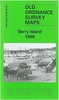

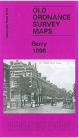
Barry 1898
Barry in 1898 in a fascinating series of reproductions of old Ordnance Survey plans in the Alan Godfrey Editions, ideal for anyone interested in the history of their neighbourhood or family. Two versions have been published for this area. The maps cover much of the town of Barry which sprang up rapidly after 1884 as a coal exporting port. Coverage stretches from Pontypridd Road and Salisbury Road eastward to Morel Street and George Street, and from North Walk southward to the No. 1 Dock. The northern part of the No.1 Dock is shown with detail including a dozen of the coal hoists, with railway sidings and even including mooring posts. Other features include GWR General Offices, locomotive repairing works, Jenner Park football ground, municipal buildings, Memorial Hall, Glamorgan
Training College, Alexandra Gardens, St Paul`s church and many streets of housing. Each map has extracts from a 1906 directory. About the Alan Godfrey Editions of the 25” OS Series:Selected towns in Great Britain and Ireland are covered by maps showing the extent of urban development in the last decades of the 19th and early 20th century. The plans have been taken from the Ordnance Survey mapping and reprinted at about 15 inches to one mile (1:4, 340). On the reverse most maps have historical notes and many also include extracts from contemporary directories. Most maps cover about one mile (1.6kms) north/south, one and a half miles (2.4kms) across; adjoining sheets can be combined to provide wider coverage.FOR MORE INFORMATION AND A COMPLETE LIST OF ALL AVAILABLE TITLES PLEASE CLICK
ON THE SERIES LINK.

Product Description
Reviews/Comments
Add New
Vouchers
No voucher codes found.
Do you know a voucher code for this product or supplier? Add it to Insights for others to use.
Do you know a voucher code for this product or supplier? Add it to Insights for others to use.
 Denmark