
 United Kingdom
 France
 Germany
 Netherlands
 Sweden
 USA
USA
 Italy
Italy
 Spain
Spain
More From Contributor


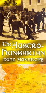
Austro-Hungarian Dual Monarchy
Packed with information, this historical map of the Austro-Hungarian Dual Monarchy shows the empire at its greatest extent in 1913, and explores its vast cultural and ethnic diversity; its shifting political allegiances and its economic and military accomplishments. * Shows sights of important battles, uprising and sieges.* Key personalities featured include Emperor Franz Josef, Leopold Graf von Berchtold, Archduke Franz Ferdinand and Emperor Charles I. *A complete timeline offers an overview of the region’s history.* Highlights major cities and towns, railways, natural resources and other geographical features, forming a comprehensive picture of the Empire.

Product Description
Reviews/Comments
Add New
Vouchers
No voucher codes found.
Do you know a voucher code for this product or supplier? Add it to Insights for others to use.
Do you know a voucher code for this product or supplier? Add it to Insights for others to use.
 Denmark