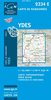
More From Contributor
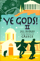
£10.99
This is a collection of sailing yarns based on Tristan Jones's huge experience of the sea which tells how he began his writing career, draws on many adventures to evoke some of the memorable people he has met & describes some of the most beautiful cruising grounds in the world. ...
Archived Product
£8.95
Indexed street plan of the city at 1:25, 000 showing street names within the city centre & names of various districts. Outside the central area information varies, with most smaller streets named, whilst many connecting larger roads have no names or numbers. The plan highlights numerous facilities & places of interest. On the reverse is a detailed topographic map at 1:200, 000 of the Yaroslavl' administrative region. Both maps are indexed for streets & locations, with the city index also listing notable buildings, theatres, cultural sites, services, etc. All place names, map legend & other text are in Russian only.IMPOTRANT
- PLEASE NOTE: Deliveries from Russia are highly irregular & we are unable to guarantee delivery dates for maps or atlases that are not currently in stock. Specifications of maps supplied, particularly street plans, may also differ to those described on the website.
...
Archived Product
£24.95
Yazd Province of Iran on a road map from the Gitashenasi Institute with relief shading showing the topography. Names of towns & some villages are shown in Farsi & Latin alphabet. Symbols highlight locations of petrol stations, historical monuments, tourist accommodation, etc. Also included are a distance table & small maps showing the administrative divisions of the province & of Iran. Map legend & brief notes about the province are in Farsi & English. ...
Archived Product
£11.50
Topographic survey of France at 1:25, 000 in IGN`s excellent TOP25 / Série Bleue series. All the maps are GPS compatible, with a 1km UTM grid plus latitude & longitude lines at 5’ intervals. Contours are at 5m intervals except for mountainous areas where the maps have contours at 10m intervals, vividly enhanced by hill shading & graphics for rocky terrain. Colouring with graphics indicates different types of vegetation or land use (deciduous or coniferous forests, moors, orchards, vineyards, etc). PLEASE NOTE: coverage of France at this scale is currently being revised – the format & the presentation of each title are indicated by the letters at the end of its Sheet Reference number (e.g. 0416ET, 3531ETR, 1923SB, etc.)MAPS WITH FULL TOURIST OVERPRINT & AN ENGLISH MAP LEGEND: all TOP25 maps & the SB editions of Série Bleue have an overprint highlighting waymarked walking trails including long-distance GR routes &, where appropriate, ski routes. Symbols indicate campsites, gîtes d’etape, refuges, equestrian centres & other recreational facilities or sites, tourist information centres, cultural heritage, etc. Towns & locations of particular interest are highlighted.- ET or OT = single-sided TOP25 map covering approx. 29x 21 km / 18x 13 miles.- ETR or OTR = waterproof & tear resistant TOP25 map covering the same area as the corresponding ET or OT number, but double-sided, printed on a smaller size sheet with a good overlap between the sides.- SB = Série Bleue map with full tourist overprint; these maps, first introduced in summer 2014, each cover approx. 29x 24km / 18x 15 miles.SÉRIE BLEUE maps with numbers ending in E (Est) or O (Ouest): most editions now indicate the GR routes, but do not show any other tourist information. Map legend is in French only. Each map covers approx. 14x 20km / 9x 12 miles. ...
Archived Product
£7.99
Ye Gods! is a light & humorous read as Jill Dudley travels around Greece, touching on the myths & legends of the old gods & how the early Greek Orthodox Church emerged from its pagan past. It is also her own & sometimes comical search for enlightenment. Jill is accompanied by her husband Harry whose reluctance to travel & probe the unknown is the perfect foil for her enthusiastic explorations. It is ideal for anyone interested in Greece who would like to learn about its myths & legends whilst being entertained; the ten chapters take the reader from Athens, up Mount Olympus, to Mt. Athos (the Holy Mountain), to the islands, & ends in Greek Cyprus, covering not only the wonderful & interesting people they meet, but also a humorous & insightful look into Dudley ...
Archived Product
£9.99
Art thou in need of hearty ale & a bed safe from brigands as you ply the highways & byways of Britain? Then Ye Olde Good Inn Guide is for you
- the essential handbook for the Tudor traveller. Packed with the finest hostelries to grace the 16th century & written with all the flavour of the language of the day, this witty & meticulously researched tome covers every county in the land & directs you to all the celebrated & charming pubs, many of which still exist today. With all the information you need, from the quality of the beer & accommodation, the merriment on offer & even the local etiquette of the day, Ye Olde Good Inn Guide is an invaluable aid to both the pub historian & the drinker who yearn for the lost age of the trusty tavern.
...
Archived Product
£3.50
Yeading in 1894 in a fascinating series of reproductions of old Ordnance Survey plans in the Alan Godfrey Editions, ideal for anyone interested in the history of their neighbourhood or family. The map covers parts of three Middlesex parishes: Northolt to the top, Hayes to the south, & Southall in the south-east. It is an entirely rural map, showing the hamlet of Yeading, with its Manor Farm & Industry pub in the south-western quarter of the map, & a stretch of the Grand Junction Canal with various docks for the brickfields running north-south near the eastern side of the map. On the reverse are directories for Hayes & Northolt, plus a plan of the New Patent Brick Co & its canal access. Please note that the eastern half of this map, covering the canal area, is also included on the Greenford map 15.07. About the Alan Godfrey Editions of the 25” OS Series: Selected towns in Great Britain & Ireland are covered by maps showing the extent of urban development in the last decades of the 19th & early 20th century. The plans have been taken from the Ordnance Survey mapping & reprinted at about 15 inches to one mile (1:4, 340). On the reverse most maps have historical notes & many also include extracts from contemporary directories. Most maps cover about one mile (1.6kms) north/south, one & a half miles (2.4kms) across; adjoining sheets can be combined to provide wider coverage.FOR MORE INFORMATION & A COMPLETE LIST OF ALL AVAILABLE TITLES PLEASE CLICK ON THE SERIES LINK. ...
Archived Product
£3.50
Yeadon in 1906 in a fascinating series of reproductions of old Ordnance Survey plans in the Alan Godfrey Editions, ideal for anyone interested in the history of their neighbourhood or family. The map covers the town of Yeadon, a few miles north of Leeds. Yeadon itself is in the top half of the map & coverage extends south to the northern tip of Rawdon, around Little Moor, Quakers` Lane, Benton Park Farm & Canada. Features include Yeadon town centre, railway branch with station, Green Lane Mill, Nether Yeadon, Henshaw, Yeadon & Guiseley Gas Works, Leafield Mills, Kirk Lane Mills, High Henshaw, Westfield Mill, Manor Mills, Hawthorn Terrace, St Andrew`s church, Town Hall Square, Albert Mill, Waterside Dye Works, Moorfield Mills, etc. On the reverse is a directory of Yeadon in 1889. About the Alan Godfrey Editions of the 25” OS Series: Selected towns in Great Britain & Ireland are covered by maps showing the extent of urban development in the last decades of the 19th & early 20th century. The plans have been taken from the Ordnance Survey mapping & reprinted at about 15 inches to one mile (1:4, 340). On the reverse most maps have historical notes & many also include extracts from contemporary directories. Most maps cover about one mile (1.6kms) north/south, one & a half miles (2.4kms) across; adjoining sheets can be combined to provide wider coverage.FOR MORE INFORMATION & A COMPLETE LIST OF ALL AVAILABLE TITLES PLEASE CLICK ON THE SERIES LINK. ...
Archived Product
£16.95
This is the true story of how a 61-year-old American woman lived alone for a year at a remote North Atlantic lighthouse called Eshaness in Scotland's most northerly territory, the Shetland Islands. It provides a day-by-day account of the events & the author's feelings during her stay. Written in a positive, candid, often humorous manner, the story encompasses a diverse array of events & happenings, including raising three orphaned lambs that became Sharma's pets & main characters in the book; the arrival of thousands of birds in Spring; & an attempt to start a garden at the lighthouse for the first time. Visits of family & friends punctured the isolation, as did the Amateur Radio Lighthouse Society's international weekend event in which Eshaness participated by operating an open house. Hundreds of people from Shetland & beyond attended & GB2ELH (Great Britain 2 Eshaness Lighthouse) had a total of 555 radio contacts over the weekend in 48 countries, including 43 lighthouses in 21 countries. The book describes how winter storms shattered the rural quiet in November, while tragedy struck in Michigan: Kiri, Sharma's much-loved dog & companion for 11 years was killed & her husb&, Dean, injured. Returning to the United States for Thanksgiving & Christmas, Krauskopf doubted whether she could cope with Eshaness any longer. Nevertheless, she did return & her trip back became a four-day adventure that features in the book. ...
Archived Product
£16.99
Photographer Rob Beighton presents a magnificent selection of photographs of North Cornwall through the seasons, an area that boasts some of the most spectacular scenery in the British Isles, coupled with the most romantic history & traditions. Among the key locations on the coast are St. Ives, voted Britain`s Best Seaside Town by the Guardian in 2007; Newquay, now a major tourist & surfing destination; Padstow, a fishing village that has become a high-profile resort, yet maintains its yearly pagan festivals; Tintagel, with its dramatically situated thirteenth-century castle, said to be the birthplace of King Arthur; & Boscastle, a picturesque village with a dramatic natural harbour. ...
Archived Product

Ye Gods! II

Ye Gods! II follows naturally on from her popular first book Ye Gods!, where Jill Dudley explored the ancient sanctuaries of Greece. Ye Gods! II is a mixture of pagan and Christian legends, and her fascination with how Christianity took over from the old Olympian gods and absorbed certain things from the pagan past. Accompanied by her somewhat reluctant travel companion and husband, Harry, Jill Dudley takes the reader to the ancient temples, monasteries and Byzantine churches of Greece.
RIP - This product is no longer available on our network. It was last seen on 25.09.2019

This page now acts as a permanent archive for this product. Add more information using the comments box below to ensure it can still be found by future generations.

Use our search facility to see if it is available from an alternative contributor.
  • External links may include paid for promotion
  • Availability: Out Of Stock
  • Supplier: Stanfords
  • SKU: 9780955383427
Availability: In Stock
£7.99

Product Description

Ye Gods! II follows naturally on from her popular first book Ye Gods!, where Jill Dudley explored the ancient sanctuaries of Greece. Ye Gods! II is a mixture of pagan & Christian legends, & her fascination with how Christianity took over from the old Olympian gods & absorbed certain things from the pagan past. Accompanied by her somewhat reluctant travel companion & husb&, Harry, Jill Dudley takes the reader to the ancient temples, monasteries & Byzantine churches of Greece.

Reviews/Comments

Add New

Price History

Vouchers

No voucher codes found.
Do you know a voucher code for this product or supplier? Add it to Insights for others to use.

Facebook

Jargon Buster

Popular - Something that is admired and liked by many people.

Supplier Information

Stanfords
Stanfords was established in 1853 and opened their iconic Covent Garden flagship store in 1901. They have become the top retailer of maps, travel books and accessories in the UK and arguably offer the largest selection of maps and travel books worldwide. Famous names such as Captain Robert Falcon Scott, Ranulph Fiennes and Michael Palin have purchased from Stanfords. They now have a shop in Bristol and both stores together with other venues operate a calendar of events including talks, book signings and exhibitions. As a specialist map retailer, the map selection is comprehensive and includes road maps, street maps and walking maps from worldwide destinations, as well as a selection of world atlases and wall maps. Books include travel guides and travel literature. Stanfords also stock globes, from miniatures made of blue marble to magnificent floor-standing globes. The website features a selection of interesting articles on travel topics.
Page Updated: 2023-11-12 20:15:36

Community Generated Product Tags

Oh No! The productWIKI community hasn't generated any tags for this product yet!
Menu