More From Contributor

£9.95
Sea kayaking map of the western coast of Scotland from See Kayak Oban publishers, showing best routes from the mainland to & around the islands, plus a street plan of Oban & plenty of tourist information. On one side is a map at 1:210, 000 approx showing the coast from Glasgow & the Clyde, Bute, Jura & Islay northwards to Fort William, Mull, Coll & the Ardnamurchan Peninsula. On the reverse a panel at approx. 1:60, 000 shows in greater detail the coast near Oban, from Scarba & the Garvellachs to Lismore & Sauna Isl&. Both maps indicate kayaking routes, locations where portage is required, selected pubs & distilleries, as well as ferry connections. A street plan of Oban highlights location of the Kayak Oban & the National Kayak School, hostel accommodation, etc. Notes provide information on getting to Oban, kayak rental & outfitting, etc. The map is illustrated with photos of interesting locations. ...
Archived Product
£6.39
A detailed topographic map of West Pennine Moors from the Ordnance Survey Explorer series, covering Blackburn, Darwen & Accrington. Edition A3; Publication date October 2008 About this series: These highly detailed maps show all the administrative boundaries, settlements as small as isolated farms, the road network down to unfenced roads & country tracks, & field boundaries (hedges & drystone walls) which make navigation across the countryside much easier. Steep gradients on roads are indicated. Various landmarks, e.g. powerlines, archaeological sites, windmills, churches & lighthouses are shown & additional graphics indicate natural terrain features such as cliffs, scree, mud & vegetation variations. The contour interval is 5 metres in the lower parts of the country & 10 metres in the uplands, & spot heights are marked. Each map covers an area of 30 x 20km (i.e. approx. 19 x 12 miles), with some double-sided maps covering more, as indicated in the individual descriptions. The maps are fully GPS compatible, with the National Grid shown at 1km intervals & latitude & longitude indicated by margin ticks at 1'. The Explorer series has replaced the earlier, green-cover Pathfinder maps. The Explorer series is now complete & covers all of Engl&, Wales & Scotl&. Some sheets for popular areas like the National Parks are still branded as Outdoor Leisure (OL) maps, but are now included in this series as the cartography is the same as that in the Explorer Maps. The Explorer maps offer a substantial improvement on the Pathfinder series, with greater use of colour, larger area per map, & stronger emphasis on information for ramblers & tourists. This series is ideal for walking & other outdoor pursuits & each map shows a large amount of information for ramblers & tourists. Public rights of way are shown (except in Scotland), together with other routes with public access: National Trails & Recreational Paths, permitted paths & bridleways, & selected cycle routes. Open access land created under the Countryside & Rights of Way Act 2000 is marked. Tourist information

Includes::
caravan & camp sites, Park & Ride locations, recreation/leisure/sport centres, museums, historic buildings, English Heritage & National Trust sites, rural pubs, etc. The map legend is in English only, except for the tourist information content which is also in French & German.

...
Archived Product
£14.99
West Pennine Moors, Blackburn, Darwen & Accrington area on a detailed topographic & GPS compatible map No. 287, waterproof version, from the Ordnance Survey’s 1:25, 000 Explorer series.MOBILE DOWNLOADS: this title & all the other OS Explorer maps include a code for downloading after purchase the digital version onto your smartphone or tablet for viewing on the OS smartphone app.OS EXPLORER SERIES: to see the list of all the titles in the OS Explorer series, both paper & waterproof versions, please click on the series link. The Explorer series, Ordnance Survey’s most detailed maps recommended for anyone enjoying outdoor activities, provides topographic coverage of Great Britain at 1:25, 000 on GPS compatible maps with hiking trails, cycling routes & extensive tourist information. Each printed map is available either on paper or as a waterproof & tear-resistant OS Active Map, as indicated in its title. Britain’s National Parks & other areas of particular tourist interest are presented on often double-sided OL (Outdoor Leisure) maps, whilst most standard format Explorers cover an area of 30 x 20km (approx. 19 x 12 miles). All three versions (paper, waterproof & digital) are the same & provide plenty of recreational & tourist information, indicating the traditional public right of way paths (except in Scotland where different laws apply), including bridleways & byways. National Trails & other long-distance paths are marked, as well as permissive footpaths or bridleways & on-road or traffic-free cycle routes with, where appropriate, their National/ Regional Cycle Network numbers. Boundaries of access land are clearly marked. A wide range of symbols provides additional tourist information, highlighting camping & caravanning sites, information offices & visitors’ centres, parking & picnicking places, country pubs, sport & recreational facilities including cycle hire locations & mountain biking trails, historic buildings & museums, etc. Exceptionally clear presentation of the landscape is provided by contours at 5m or in the uplands at 10m intervals, with additional spot heights plus colouring and/or graphics for different types of woodlands, orchards, heath, marshl&, scree or boulders, & other topographic features. For GPS users the maps have British National Grid lines at 1km intervals, with latitude & longitude given by margin ticks at 1`. Clearly laid out map legend

Includes::
French & German translations for the tourist information symbols.

...
Archived Product
£8.99
West Pennine Moors, Blackburn, Darwen & Accrington area on a detailed topographic & GPS compatible map No. 287, paper version, from the Ordnance Survey’s 1:25, 000 Explorer series.MOBILE DOWNLOADS: this title & all the other OS Explorer maps include a code for downloading after purchase the digital version onto your smartphone or tablet for viewing on the OS smartphone app.OS EXPLORER SERIES: to see the list of all the titles in the OS Explorer series, both paper & waterproof versions, please click on the series link. The Explorer series, Ordnance Survey’s most detailed maps recommended for anyone enjoying outdoor activities, provides topographic coverage of Great Britain at 1:25, 000 on GPS compatible maps with hiking trails, cycling routes & extensive tourist information. Each printed map is available either on paper or as a waterproof & tear-resistant OS Active Map, as indicated in its title. Britain’s National Parks & other areas of particular tourist interest are presented on often double-sided OL (Outdoor Leisure) maps, whilst most standard format Explorers cover an area of 30 x 20km (approx. 19 x 12 miles). All three versions (paper, waterproof & digital) are the same & provide plenty of recreational & tourist information, indicating the traditional public right of way paths (except in Scotland where different laws apply), including bridleways & byways. National Trails & other long-distance paths are marked, as well as permissive footpaths or bridleways & on-road or traffic-free cycle routes with, where appropriate, their National/ Regional Cycle Network numbers. Boundaries of access land are clearly marked. A wide range of symbols provides additional tourist information, highlighting camping & caravanning sites, information offices & visitors’ centres, parking & picnicking places, country pubs, sport & recreational facilities including cycle hire locations & mountain biking trails, historic buildings & museums, etc. Exceptionally clear presentation of the landscape is provided by contours at 5m or in the uplands at 10m intervals, with additional spot heights plus colouring and/or graphics for different types of woodlands, orchards, heath, marshl&, scree or boulders, & other topographic features. For GPS users the maps have British National Grid lines at 1km intervals, with latitude & longitude given by margin ticks at 1`. Clearly laid out map legend

Includes::
French & German translations for the tourist information symbols.

...
Archived Product
£11.19
Laminated waterproof edition of a detailed topographic map from the Ordnance Survey Explorer series, covering Blackburn, Darwen & Accrington. Edition A3; Publication date October 2008 About this series: These highly detailed maps show all the administrative boundaries, settlements as small as isolated farms, the road network down to unfenced roads & country tracks, & field boundaries (hedges & drystone walls) which make navigation across the countryside much easier. Steep gradients on roads are indicated. Various landmarks, e.g. powerlines, archaeological sites, windmills, churches & lighthouses are shown & additional graphics indicate natural terrain features such as cliffs, scree, mud & vegetation variations. The contour interval is 5 metres in the lower parts of the country & 10 metres in the uplands, & spot heights are marked. Each map covers an area of 30 x 20km (i.e. approx. 19 x 12 miles), with some double-sided maps covering more, as indicated in the individual descriptions. The maps are fully GPS compatible, with the National Grid shown at 1km intervals & latitude & longitude indicated by margin ticks at 1'. The Explorer series has replaced the earlier, green-cover Pathfinder maps. The Explorer series is now complete & covers all of Engl&, Wales & Scotl&. Some sheets for popular areas like the National Parks are still branded as Outdoor Leisure (OL) maps, but are now included in this series as the cartography is the same as that in the Explorer Maps. The Explorer maps offer a substantial improvement on the Pathfinder series, with greater use of colour, larger area per map, & stronger emphasis on information for ramblers & tourists. This series is ideal for walking & other outdoor pursuits & each map shows a large amount of information for ramblers & tourists. Public rights of way are shown (except in Scotland), together with other routes with public access: National Trails & Recreational Paths, permitted paths & bridleways, & selected cycle routes. Open access land created under the Countryside & Rights of Way Act 2000 is marked. Tourist information

Includes::
caravan & camp sites, Park & Ride locations, recreation/leisure/sport centres, museums, historic buildings, English Heritage & National Trust sites, rural pubs, etc. The map legend is in English only, except for the tourist information content which is also in French & German.

...
Archived Product
£15.99
Western Pomerania at 1:200, 000 from Höfer Verlag in a series of road maps of areas which used to be part of Germany or the Austro-Hungarian Empire, showing both current & the old German place names. In many places former settlements which now no longer exist are also named. Present road & rail networks are supplemented by historical information, e.g. former railway lines. There is no relief detail apart from spot heights. Forests, nature reserves, national park boundaries & locations of interest are marked, & symbols indicate campsites, historical sites, etc. The maps have no geographical coordinates. * Map legend

Includes::
English.* As the maps have dual place names, the print is rather small, but each title comes with a special magnifying lens attached to the map cover. Also included is a booklet with separate, cross-referenced indexes for each set of names & a street plan of the central part of the area’s main city, showing both old & current street layout.* In this title:* a street plan of central Szczecin/ Stettin.

...
Archived Product
£2.95
West Retford & Babworth in 1884 in a fascinating series of reproductions of old Ordnance Survey plans in the Alan Godfrey Editions, ideal for anyone interested in the history of their neighbourhood or family. Selected towns in Great Britain & Ireland are covered by maps showing the extent of urban development in the last decades of the 19th & early 20th century. In this title: the map covers West Retford & extends westward to Babworth Hall. Features include West Retford Hall, River Idle, St Michael's church, Holy Trinity Hospital, West Field area, GNR railway with station, engine shed, MSL railway with Whisker Hill Junction, East Retford Water Works, Biggins Farm, Ordsall House, Babworth Hall & Park, All Saints church, Babworth Farm. On the reverse is an 1891 Retford directory, entries A-Me. About the Alan Godfrey Editions of the 25 ...
Archived Product
£3.50
West Retford & Babworth in 1884 in a fascinating series of reproductions of old Ordnance Survey plans in the Alan Godfrey Editions, ideal for anyone interested in the history of their neighbourhood or family. The map covers West Retford & extends westward to Babworth Hall. Features include West Retford Hall, River Idle, St Michael`s church, Holy Trinity Hospital, West Field area, GNR railway with station, engine shed, MSL railway with Whisker Hill Junction, East Retford Water Works, Biggins Farm, Ordsall House, Babworth Hall & Park, All Saints church, Babworth Farm, etc. On the reverse is an 1891 Retford directory, entries A to Me. About the Alan Godfrey Editions of the 25” OS Series: Selected towns in Great Britain & Ireland are covered by maps showing the extent of urban development in the last decades of the 19th & early 20th century. The plans have been taken from the Ordnance Survey mapping & reprinted at about 15 inches to one mile (1:4, 340). On the reverse most maps have historical notes & many also include extracts from contemporary directories. Most maps cover about one mile (1.6kms) north/south, one & a half miles (2.4kms) across; adjoining sheets can be combined to provide wider coverage.FOR MORE INFORMATION & A COMPLETE LIST OF ALL AVAILABLE TITLES PLEASE CLICK ON THE SERIES LINK. ...
Archived Product
£3.50
West Streatham & Tooting in 1894 in a fascinating series of reproductions of old Ordnance Survey plans in the Alan Godfrey Editions, ideal for anyone interested in the history of their neighbourhood or family. The map covers the eastern part of Tooting Graveney & west Streatham, an area stretching from Foulser Road eastward to Pendennis Road & Polworth Road, & from Tooting Bec Common southward to Barrow Road. Features include Tooting College, Newlands House asylum, Furzedown Park, Tooting Graveney Common, Manor Park, Streatham High Road, Streatham Green, St Leonard`s church, St Alban`s church, Streatham Park & Streatham station. There is a good selection of street directories on the reverse. About the Alan Godfrey Editions of the 25” OS Series Selected towns in Great Britain & Ireland are covered by maps showing the extent of urban development in the last decades of the 19th & early 20th century. The plans have been taken from the Ordnance Survey mapping & reprinted at about 15 inches to one mile (1:4, 340). On the reverse most maps have historical notes & many also include extracts from contemporary directories. Most maps cover about one mile (1.6kms) north/south, one & a half miles (2.4kms) across; adjoining sheets can be combined to provide wider coverage.FOR MORE INFORMATION & A COMPLETE LIST OF ALL AVAILABLE TITLES PLEASE CLICK ON THE SERIES LINK. ...
Archived Product
£11.99
West Sussex & The South Downs in the Pathfinder Guides series, produced in association with Ordnance Survey & published by Crimson; comprising a range of walking guides to popular British destinations. Each Pathfinder guide

Includes::
28 varied walks ranging from easy strolls to exhilarating hikes & is accompanied by 1:25, 000 Ordnance Survey mapping with marked, colour-coded routes. Introductory sections profile the county or region covered, with recommendations on the best time to visit & a brief explanation of GPS. An

...
Archived Product

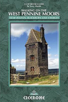
West Pennine Moors Walking

Walking on the West Pennines Moors is Terry Marsh`s Cicerone guide to walking and rambling around the moorlands of Lancashire. The guide covers a total of 30 walks in total across the region. The areas that are covered include Rivington Pike, Sunnyhurst Wood, Turton Moor, Chetham Close, Haslingden Grane and the Irwell Valley and are organised by area in sections covering Rivington and Anglezarke, Roddlesworth and Darwen, Turton and Entwistle and Ramsbottom, Hoddlesden and Haslingden Grane. A detailed introduction includes information on Geography and natural Histroy, human influence, a brief introduction to the lancashire valleys and tips on walking safely. Each walk gives details on estimated timings, the relevant map, a difficulty category and starting points. Detailed route
descriptions are accompanied by sketch line diagrams mapping the route in addition to black and white photographs illustrating some of the highlights of the region.
RIP - This product is no longer available on our network. It was last seen on 25.09.2019

This page now acts as a permanent archive for this product. Add more information using the comments box below to ensure it can still be found by future generations.

Use our search facility to see if it is available from an alternative contributor.
  • External links may include paid for promotion
  • Availability: Out Of Stock
  • Supplier: Stanfords
  • SKU: 9781852845803
Availability: In Stock
£12.95

Product Description

Walking on the West Pennines Moors is Terry Marsh`s Cicerone guide to walking & rambling around the moorlands of Lancashire. The guide covers a total of 30 walks in total across the region. The areas that are covered include Rivington Pike, Sunnyhurst Wood, Turton Moor, Chetham Close, Haslingden Grane & the Irwell Valley & are organised by area in sections covering Rivington & Anglezarke, Roddlesworth & Darwen, Turton & Entwistle & Ramsbottom, Hoddlesden & Haslingden Grane. A detailed introduction

Includes::
information on Geography & natural Histroy, human influence, a brief introduction to the lancashire valleys & tips on walking safely. Each walk gives details on estimated timings, the relevant map, a difficulty category & starting points. Detailed route descriptions are accompanied by sketch line diagrams mapping the route in addition to black & white photographs illustrating some of the highlights of the region.

Reviews/Comments

Add New

Price History

Vouchers

No voucher codes found.
Do you know a voucher code for this product or supplier? Add it to Insights for others to use.

Facebook

Jargon Buster

Black - A colour which does not emit any colour of the spectrum. Black absorbs all frequencies of the spectrum.
White - A colour combining all colours
Human - A highly developed and adapted mamal and deminant species on earth
Wood - A hard material found in trees. Used for tool making, fuel and construction.
Natural - not manmade

Supplier Information

Stanfords
Stanfords was established in 1853 and opened their iconic Covent Garden flagship store in 1901. They have become the top retailer of maps, travel books and accessories in the UK and arguably offer the largest selection of maps and travel books worldwide. Famous names such as Captain Robert Falcon Scott, Ranulph Fiennes and Michael Palin have purchased from Stanfords. They now have a shop in Bristol and both stores together with other venues operate a calendar of events including talks, book signings and exhibitions. As a specialist map retailer, the map selection is comprehensive and includes road maps, street maps and walking maps from worldwide destinations, as well as a selection of world atlases and wall maps. Books include travel guides and travel literature. Stanfords also stock globes, from miniatures made of blue marble to magnificent floor-standing globes. The website features a selection of interesting articles on travel topics.
Page Updated: 2023-11-12 20:15:36

Community Generated Product Tags

Oh No! The productWIKI community hasn't generated any tags for this product yet!
Menu