
 United Kingdom
 France
 Germany
 Netherlands
 Sweden
 USA
USA
 Italy
Italy
 Spain
Spain
More From Contributor
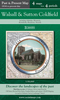


Walsall South East 1901
Walsall South East in 1901 in a fascinating series of reproductions of old Ordnance Survey plans in the Alan Godfrey Editions, ideal for anyone interested in the history of their neighbourhood or family. Selected towns in Great Britain and Ireland are covered by maps showing the extent of urban development in the last decades of the 19th and early 20th century.In this title: the map covers the south-eastern area of Walsall, including part of the town centre and the Paddock Ward area. Coverage extends from Caldmore Road eastward to the Rushall Canal, and from Upper Walhouse Street southward to Highgate Road. Features include Windmill area, St Matthew's church, Summit Buckle Works, St Michael & All Angels church, brewery, Doveridge, Spring Hill, High Street, Alpha Tube Works, St
Paul's church, General Post Office, Public Baths, St George's church, The Chuckery, The Shrubbery, Chuckery Foundry, Gorway House, Brook House Farm, Gillity Bridge etc. On the reverse is a selection of street directory entries, including Ablewell Street, Bath Street, Birmingham Road, Bridge Street, Digbeth, Hart Street, High Street, Highgate Road, Holtshill Lane, Sutton Road.About the Alan Godfrey Editions of the 25
Paul's church, General Post Office, Public Baths, St George's church, The Chuckery, The Shrubbery, Chuckery Foundry, Gorway House, Brook House Farm, Gillity Bridge etc. On the reverse is a selection of street directory entries, including Ablewell Street, Bath Street, Birmingham Road, Bridge Street, Digbeth, Hart Street, High Street, Highgate Road, Holtshill Lane, Sutton Road.About the Alan Godfrey Editions of the 25
Product Description
Reviews/Comments
Add New
Vouchers
No voucher codes found.
Do you know a voucher code for this product or supplier? Add it to Insights for others to use.
Do you know a voucher code for this product or supplier? Add it to Insights for others to use.
 Denmark