
 United Kingdom
 France
 Germany
 Netherlands
 Sweden
 USA
USA
 Italy
Italy
 Spain
Spain
More From Contributor


Trinidad & Tobago F&B
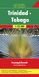
Very clear map of the two islands with road information and place names easy to read. The map has the same geographic content as that published by Rough Guides, but with different colouring and the presentation of the topography - here with vivid relief shading rather than with contours and altitude tinting, and without the bathymetric tinting over the surrounding sea. Altitudes for a few peaks are marked, and swamps and reefs are also shown.The clear road detail includes minor roads and tracks, with intermediate driving distances marked on main routes and selected petrol stations. Internal administrative boundaries and names are clearly marked, and reserves and protected areas are shown. Symbols show airports, harbours and many other tourism features and landmarks e.g. golf courses,
zoos, botanical gardens, waterfalls, beaches and watersport sites, volcanoes, campsites and other places of interest. Latitude and longitude lines are drawn at 5’ intervals and the multilingual map legend includes English.
zoos, botanical gardens, waterfalls, beaches and watersport sites, volcanoes, campsites and other places of interest. Latitude and longitude lines are drawn at 5’ intervals and the multilingual map legend includes English.

Product Description
Reviews/Comments
Add New
Intelligent Comparison
Archived Product
Trinidad & Tobago Stanfords
£11.19
Archived Product

Trinidad & Tobago ITMB Stanfords
£9.99
Archived Product

Trinidad And Tobago Stanfords
£25.00
Archived Product

Trinidad And Tobago Stanfords
£8.99
Archived Product

Flag Of Trinidad & Tobago Stanfords
£8.99
Archived Product
Birds Of Trinidad & Tobago Stanfords
£7.95
Archived Product

Birds Of Trinidad & Tobago Stanfords
£25.00
Archived Product
Birds Of Trinidad & Tobago Stanfords
£40.00
Vouchers
No voucher codes found.
Do you know a voucher code for this product or supplier? Add it to Insights for others to use.
Do you know a voucher code for this product or supplier? Add it to Insights for others to use.
 Denmark