More From Contributor

£9.99
Times New Romanian provides a picture of Romania today through the individual first-person narratives of people who chose to go & make a life in this country. Each chapter a voice, each story in Times New Romanian provides readers with a look into the Romanian world
- the way things work, the vitality of the people, the living heritage of rural traditions, ordinary life
- sometimes dark, sometimes sublime, always interesting. In a land full of character & contradiction, there is a strong attraction for those with the spirit to meet the challenges, where the one thing you can be sure of is the unpredictable. Life is not always easy. These stories will tell you why... If you want to know more about Romanians & their country, the voices in Times New Romanian make for an enjoyable & lively read. Inspired by Studs Terkel & Tony Parker, Nigel used their oral history style & his own experience in Romania to guide him in recording these interviews.

...
Archived Product
£19.99
A stunning paperback collection of classic Morpurgo novels set in World War I, World War II & the Afghanistan conflict. Told ...
Archived Product
£30.00
A new edition of this popular atlas from the prestigious & authoritative Times Atlas range. This sixth edition contains the latest satellite images & fascinating historical images, & contains the breadth, scale & detail to make it an ideal reference resource for school, home & business. The atlas has been brought fully up-to-date to provide a detailed & attractive picture of the world today. The beautifully illustrated introductory section gives a detailed profile of today's world & covers major contemporary geographical & global issues
- such as environment & population growth
- through maps, images, statistics & graphics. The fully up-to-date reference maps give exceptional detail & provide accurate, accessible & attractive coverage, helping you explore the world. 44 city plans of the world's major cities, showing major places of interest, have also been revised. A comprehensive guide to the world's states & territories including flags, profiles & key facts in included, making this the ideal reference atlas for home, school or office.MAIN FEATURES 104 pages of authoritative mapping of the whole world Plans of 44 of the world's major cities Geographical reference section with flags, statistics & facts for the world's states & territories Statistics & world maps on major geographical themes, including earthquakes, population, cities, climate & the environment The latest images of the earth from space Historical mapping of the world from 1858 to the present day 45, 000 index entries

...
Archived Product
£3.99
An engaging Times Tables activity book to really help boost your child`s progress at every stage of their learning! Including helpful questions & answers, this Maths book provides reassurance whilst supporting your child`s learning at home. Combining useful Maths practice with engaging, colourful illustrations, this Times Tables practice book helps to boost your child`s confidence & develop good learning habits for life. Each fun activity is designed to give your child a real sense of achievement. Included in this book: * questions that allow children to practise the important skills learned at school * colourful activities that make learning fun & motivate children to learn at home * helpful tips & answers so that you can support your child`s learning ...
Archived Product
£50.00
The Times Universal Atlas of the World contains 170 pages of fully updated mapping which reflects recent geopolitical & geographical changes in the world. Detailed geographical information features alongside the mapping to provide greater contextual knowledge for the cartography. A special feature of this atlas is the inclusion of a historical mapping section, featuring unique images from the 150 year history of Times atlases. These images not only illustrate the dramatic changes of the world we live in, but also the development of cartography over the years. Street plans of 46 of the world ...
Archived Product
£50.00
The authority & accuracy of a top range Times World Atlas at an affordable price. Fully updated with extra information next to each map, making this a perfect reference tool for exploring the world. The latest mapping provides an amazingly detailed view of the world with extensive geographical information beside each map, giving the reader a greater understanding of each area. FULLY UP-TO-DATE MAPPING The reference mapping, produced in the beautifully clear & distinctive Times style has been completely updated with thousands of changes reflecting recent geopolitical & geographical change around the world. As with all atlases in the Times range it offers great authority, outstanding quality & attention to detail. MAIN FEATURES * A fascinating collection of maps from the last 150 years of world atlases included in an expanded historical mapping section. * Satellite image shown for each continent along with textual description. * The latest satellite images from around the world showcased in the imagery section. * Geographical reference section with flags, statistics & facts for all the world`s countries. * Over 50, 000 index entries. ” The definitive guide book to the world. It makes your mind run wild & your feet itch.” Jake Meyer ...
Archived Product
£6.50
Plan of the city at 1:15, 000 with separate enlargements for four of its central areas. Notable buildings & places of interest are highlighted. Tram & troleybus lines & railways are marked. A range of symbols denotes many specific features e.g. hotels & campsites, markets, filling stations, museums, car parks. Many locations are numbered & listed on the reverse. Four separate insets show the city ...
Archived Product
£17.95
Timisoara in the heart of Transylvania in a series of guides to “ Little Global Cities” from Kerber Verlag. All the text is in English, German & Romanian. Little Global Cities series is designed to provide informative & interesting guidebooks to smaller cities of Eastern Europe & the Balkans, aimed at tourist who like to venture off the beaten track & explore old & new city quarters, meet the locals, etc. All the text is presented in three languages: English, German plus the language of the relevant country. The guides describe not only each city’s main sites but also more out of the way corners, many chosen by the locals to provide a better idea of the flavour & the history of their town. The guides include recommendations of restaurants & cafes, as well as ideas for exploring the surrounding environs. Each title

Includes::
a pull out street plan cross-referenced to the guide.

...
Archived Product
£36.95
Military topographic survey mapping with contours. These maps are designed primarily as flying charts for aircraft, but they are useful as general topographical maps where nothing else is available. Contours are shown in feet, with elevation colouring & spot heights. Towns, villages, major roads, railways & airports are shown (but please note that many of the smaller settlements are not named, & the road information is not necessarily up to date). Some air navigation information also appears on the map, such as radio beacons & restricted flying zones. Double-sided sheet. ...
Archived Product
£8.99
Meet Timmy Failure, founder of the best detective agency in town
- Total Failure, Inc. Timmy may only be eleven, but with the
...
Archived Product

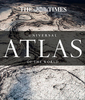
Times Universal Atlas Of The World

The authority and accuracy of a top range Times World Atlas at an affordable price. Fully updated with extra information next to each map, making this a perfect reference tool for exploring the world. The latest mapping provides an amazingly detailed view of the world with detailed geographical information beside each map giving the reader a greater understanding of each area. FULLY UP-TO-DATE MAPPING The reference mapping, produced in the beautifully clear and distinctive Times style has been completely updated with thousands of changes reflecting recent geopolitical and geographical change around the world. As with all atlases in the Times range it offers great authority, outstanding quality and attention to detail. UPDATES INCLUDE World's newest country South Sudan Dissolution of
Netherlands Antilles Samoa and Tokelau jump dateline Greenland ice cap Disputed areas of the world reviewed MAIN FEATURES A fascinating collection of maps from the last 150 years of world atlases included in an expanded historical mapping section. Satellite image shown for each continent along with textual description. The latest satellite images from around the world showcased in the imagery section. Geographical reference section with flags, statistics and facts for all the world's countries. Over 50, 000 index entries. The definitive guide book to the world. It makes your mind run wild and your feet itch. Jake Meyer
RIP - This product is no longer available on our network. It was last seen on 25.09.2019

This page now acts as a permanent archive for this product. Add more information using the comments box below to ensure it can still be found by future generations.

Use our search facility to see if it is available from an alternative contributor.
  • Availability: Out Of Stock
  • Supplier: Stanfords
  • SKU: 9780007455225
Availability: In Stock
£50.00

Product Description

The authority & accuracy of a top range Times World Atlas at an affordable price. Fully updated with extra information next to each map, making this a perfect reference tool for exploring the world. The latest mapping provides an amazingly detailed view of the world with detailed geographical information beside each map giving the reader a greater understanding of each area. FULLY UP-TO-DATE MAPPING The reference mapping, produced in the beautifully clear & distinctive Times style has been completely updated with thousands of changes reflecting recent geopolitical & geographical change around the world. As with all atlases in the Times range it offers great authority, outstanding quality & attention to detail. UPDATES INCLUDE World's newest country South Sudan Dissolution of Netherlands Antilles Samoa & Tokelau jump dateline Greenland ice cap Disputed areas of the world reviewed MAIN FEATURES A fascinating collection of maps from the last 150 years of world atlases included in an expanded historical mapping section. Satellite image shown for each continent along with textual description. The latest satellite images from around the world showcased in the imagery section. Geographical reference section with flags, statistics & facts for all the world's countries. Over 50, 000 index entries. The definitive guide book to the world. It makes your mind run wild & your feet itch. Jake Meyer

Reviews/Comments

Add New

Intelligent Comparison

Oooops!
We couldn't find anything!
Perhaps this product's unique.... Or perhaps we are still looking for comparisons!
Click to bump this page and we'll hurry up.

Price History

Vouchers

No voucher codes found.
Do you know a voucher code for this product or supplier? Add it to Insights for others to use.

Facebook

Jargon Buster

Ice - Frozen water, the solid state of water.
Date - A day on a calendar
Date - A social activity whith a current or potential partner
World - A physical grouping, commonly used to describe earth and everything associated with ti
Quality - An object that has quality is superior in function and finish than a less quality object.
Ice - Frozen water, Ice is cold to the touch and forms when water reaches 0 degrees centigrade.
Affordable - Something that is within a set price range that can be afforded due to its reasonable price.
Reference - To prove evidence with a back up source.

Supplier Information

Stanfords
Stanfords was established in 1853 and opened their iconic Covent Garden flagship store in 1901. They have become the top retailer of maps, travel books and accessories in the UK and arguably offer the largest selection of maps and travel books worldwide. Famous names such as Captain Robert Falcon Scott, Ranulph Fiennes and Michael Palin have purchased from Stanfords. They now have a shop in Bristol and both stores together with other venues operate a calendar of events including talks, book signings and exhibitions. As a specialist map retailer, the map selection is comprehensive and includes road maps, street maps and walking maps from worldwide destinations, as well as a selection of world atlases and wall maps. Books include travel guides and travel literature. Stanfords also stock globes, from miniatures made of blue marble to magnificent floor-standing globes. The website features a selection of interesting articles on travel topics.
Page Updated: 2023-11-12 20:15:36

Community Generated Product Tags

Oh No! The productWIKI community hasn't generated any tags for this product yet!
Menu