
 United Kingdom
 France
 Germany
 Netherlands
 Sweden
 USA
USA
 Italy
Italy
 Spain
Spain
More From Contributor


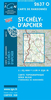
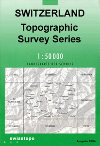
St-Cergue Swisstopo 260
St-Cergue, map No. 260, in the standard topographic survey of Switzerland at 1:50, 000 from Swisstopo, i.e. without the special overprint highlighting walking trails, local bus stops, etc, presented in Swisstopo’s hiking editions of the 50K survey. Coverage includes the French side of the border with Morez, Les Rousses and Co de la Faucille.Highly regarded for their superb use of graphic relief and hill shading, the maps give an almost 3-D picture of Switzerland`s mountainous terrain. Contours are at 20m intervals. All the maps have a 1-km grid with the Swiss national coordinates. This standard version of the 50K survey covers the whole country on 78 small format sheets, with special larger format maps published for several popular tourist destinations. Small format sheets cover
an area of 35 x 24 km (21 x 15 miles approx) and have map legend in the language of the area covered by the map. The special larger sheets cover 50 x 35 km (31 x 22 miles approx) and have no map legend, but a separate leaflet can be provided instead.PLEASE NOTE: the hiking editions of the 1:50, 000 Swisstopo survey are listed on our website in a separate series.
an area of 35 x 24 km (21 x 15 miles approx) and have map legend in the language of the area covered by the map. The special larger sheets cover 50 x 35 km (31 x 22 miles approx) and have no map legend, but a separate leaflet can be provided instead.PLEASE NOTE: the hiking editions of the 1:50, 000 Swisstopo survey are listed on our website in a separate series.

Product Description
Reviews/Comments
Add New
Intelligent Comparison
Archived Product
St-Cergue Swisstopo Hiking 260T Stanfords
£18.99
Archived Product
St-Leonard Swisstopo 1286 Stanfords
£12.99
Archived Product
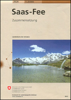
Saas-Fee Swisstopo 2526 Stanfords
£20.99
Archived Product

Sierre Swisstopo 1287 Stanfords
£12.99
Archived Product
St-Maurice Swisstopo 272 Stanfords
£12.99
Archived Product
Ste-Croix Swisstopo 1182 Stanfords
£12.99
Archived Product

Orbe Swisstopo 1202 Stanfords
£12.99
Archived Product

Beatenberg Swisstopo 1208 Stanfords
£12.99
Vouchers
No voucher codes found.
Do you know a voucher code for this product or supplier? Add it to Insights for others to use.
Do you know a voucher code for this product or supplier? Add it to Insights for others to use.
 Denmark