
 United Kingdom
 France
 Germany
 Netherlands
 Sweden
 USA
USA
 Italy
Italy
 Spain
Spain
More From Contributor


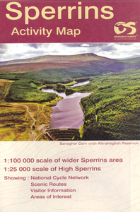
Sperrins Activity Map
Sperrin Mountains at 1:25, 000 on a large, double-sided Activity Map from the Ordnance Survey of Northern Ireland designed with outdoor enthusiasts in mind: waterproof and tear-resistant, topographic and GPS compatible, with hiking and cycling routes and tourist information for the area, plus coverage of the north-western part of the country at 1:100, 000.On one side a detailed map at 1:25, 000 shows the Sperrin Mountains with contours at 10m intervals and an overprint highlighting waymarked hiking trails. On the reverse is touring map of north-western Northern Ireland at 1:100, 000, with altitude tints and contours at 100m intervals showing the region`s topography, plus colours and/or graphics indicating different types of woodlands, beaches, etc. Road network highlights scenic
routes and Sustrans National Cycle Network. A wide range of symbols mark various places of interest including campsites, nature reserves, antiquities and historical remains, recreational facilities, etc. Both sides of the map are GPS compatible, with the Sperrin Mountains map showing Irish National Grid at 1km intervals. Also provided is general information about the area and contact addresses of various relevant organizations.To see the list of titles in this series please click on the series link.
routes and Sustrans National Cycle Network. A wide range of symbols mark various places of interest including campsites, nature reserves, antiquities and historical remains, recreational facilities, etc. Both sides of the map are GPS compatible, with the Sperrin Mountains map showing Irish National Grid at 1km intervals. Also provided is general information about the area and contact addresses of various relevant organizations.To see the list of titles in this series please click on the series link.

Product Description
Reviews/Comments
Add New
Intelligent Comparison
Archived Product
The Mournes Activity Map Stanfords
£7.80
Archived Product
Switzerland Activity Map Stanfords
£14.50
Vouchers
No voucher codes found.
Do you know a voucher code for this product or supplier? Add it to Insights for others to use.
Do you know a voucher code for this product or supplier? Add it to Insights for others to use.
 Denmark