More From Contributor
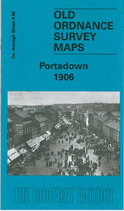
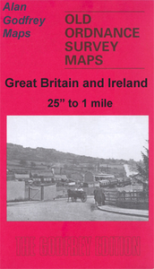
£11.99
The Portable Mosquito Killer by Lifesystems, is a battery powered insect killer unit that can be used independently in large tents, huts & hotels where mains power is not readily available. Perfect for travel & the outdoors. The unit slowly propels an odourless scent that is harmless to humans, but extremely effective against biting insects. The unit is supplied with a single cartridge that provides up to 7 nights* protection. Replacements tablets can be bought separately. It repels: mosquitoes, midges & other biting insects. The unit requires 2 AA batteries which will also last Approx. 7 nights. Active ingredient (s): 45.1% Transfluthrin. ...
Archived Product
£17.99
Topographic survey of Portugal at 1:50, 000 from the Instituto Geográfico do Exército, the country’s military survey organisation. The maps have contours at 20m intervals & in addition to the standard features shown on topographic mapping at this scale also indicate various types of terrain or vegetation (s&, terraces, rocks, woodlands, vineyards, etc). Each sheet covers an area of 32 x 20km (20 x 12.5 miles approx). The maps have a 1-km UTM grid plus latitude & longitude coordinates for the map corners. Map legend & a glossary of terms used on the maps include English.EDITION DATES: most titles in this series date from 1990s or later. To see all the titles in this series please click on the series link. ...
Archived Product
£17.99
Topographic survey of Portugal at 1:100, 000 from the Instituto Geográfico Português, the country’s civilian survey organisation. The maps have contours at 50m intervals & in addition to the standard features shown on topographic mapping at this scale also indicate various types of vegetation (vineyards, olive groves, etc). Each sheet covers an area of 64 x 40km (40 x 25 miles approx). The maps have latitude & longitude margin ticks at 1’ intervals, plus show UTM coordinates for the map corners. Map legend is in Portuguese only.PLEASE NOTE
- EDITION DATES: some sheets at this scale date back to the 1950s or 1960s. For more recent editions please see IGP’s 1:25, 000 series where each 50K map is divided into four quarters. To see all the titles in the 1:100, 000 series please click on the series link.
...
Archived Product
£17.99
Topographic survey of Portugal at 1:50, 000 from the Instituto Geográfico Português, the country’s civilian survey organisation. The maps have contours at 25m intervals & in addition to the standard features shown on topographic mapping at this scale also indicate various types of vegetation (vineyards, olive groves, etc). Each sheet covers an area of 32 x 20km (20 x 12.5miles approx). The maps have latitude & longitude margin ticks at 1’ intervals & UTM coordinates for the map corners – each sheet also shows conversion details from BBLx (Bessel-Bonnie system, Datum Lisbon) to UTM. Map legend is in Portuguese only.EDITION DATES: most titles in this series have now been updated in the 1990s or later. To see all the titles in this series please click on the series link. ...
Archived Product
£6.95
Topographic coverage of mainland Spain at 1:50, 000 in the MTN50 (Mapa Topográfico Nacional) series from the Centro Nacional de Información Geografica, the country’s civilian survey organization. The maps have contours at 20m intervals, enhanced by relief shading, plus colouring and/or graphics to show different types of terrain, vegetation or land use. Boundaries of national parks & other protected areas are marked. In addition to all the usual information featured on topographic mapping at this scale, detailed presentation of the road & rail networks, rural tracks & paths, etc, the maps also show campsites & mountain refuges. On more recent editions some GRs, the official long-distance hiking routes, are also marked (although not as clearly as on hiking maps from other publishers). Each map covers 29.5x 18.5 km (with adjustments in the border or coastal areas). The maps have a 1-km UTM grid, plus margin ticks for latitude & longitude at 1` intervals. Map legend is in Spanish only.HOW TO CHOOSE THE RIGHT 50K MAP: all the titles in CNIG’s 200K Provincial Road Maps series at 1:200, 000 are overprinted with the grid for the 1:50, 000 maps & can be used to see the area covered by each 50K title. TO SEE THE LIST OF TITLES IN THIS SERIES PLEASE CLICK ON THE SERIES LINK.PLEASE NOTE
- MAP TITLES: the grids shown on our website serve both the civilian & the military 1:50, 000 topographic series. Although the areas covered by maps in both series are identical (apart from some border or coastal sheets), occasionally map titles differ – only one title is shown on the grid, usually the military one. In Galicia, the Basque country & in the Catalan speaking areas the tendency now is to use local place names rather than the often better known Castilian ones. Where possible, both versions are included in our titles. Map titles listed on our website are based on information received by us at the time of publication, but sometimes maps arrive showing a completely different title! As long as the map number is as ordered, the correct map has been supplied.
...
Archived Product
£17.99
Topographic survey of Portugal at 1:50, 000 from the Instituto Geográfico do Exército, the country’s military survey organisation. The maps have contours at 20m intervals & in addition to the standard features shown on topographic mapping at this scale also indicate various types of terrain or vegetation (s&, terraces, rocks, woodlands, vineyards, etc). Each sheet covers an area of 32 x 20km (20 x 12.5 miles approx). The maps have a 1-km UTM grid plus latitude & longitude coordinates for the map corners. Map legend & a glossary of terms used on the maps include English.EDITION DATES: most titles in this series date from 1990s or later. To see all the titles in this series please click on the series link. ...
Archived Product
£17.99
Topographic survey of Portugal at 1:50, 000 from the Instituto Geográfico Português, the country’s civilian survey organisation. The maps have contours at 25m intervals & in addition to the standard features shown on topographic mapping at this scale also indicate various types of vegetation (vineyards, olive groves, etc). Each sheet covers an area of 32 x 20km (20 x 12.5miles approx). The maps have latitude & longitude margin ticks at 1’ intervals & UTM coordinates for the map corners – each sheet also shows conversion details from BBLx (Bessel-Bonnie system, Datum Lisbon) to UTM. Map legend is in Portuguese only.EDITION DATES: most titles in this series have now been updated in the 1990s or later. To see all the titles in this series please click on the series link. ...
Archived Product
£12.99
Long ago, high days & holidays were celebrated throughout the year with foods that were available only in that particular season, & although we still celebrate festivals such as Easter & Christmas, others such as Michaelmas & Twelfth Night have fallen by the wayside. In this entertaining & valuable book, you will discover the fascinating customs & traditions linked with these festivals & fairs, interwoven with a great many of the easy-to-follow traditional, classic & modern recipes associated with them. These include such inspiring recipes as Dublin Coddle & Bacon, Cabbage, Potato & Cheese Bake for St Patrick's Day; Orange Blossom Cake & violet Ice Cream for Mothers' Day; Easter Lamb with Red Wine Sauce; Lincolnshire Whitsun Cake; Halloween Broomstick Bangers & Pumpkin Custard Tart; Christmas Snowflake Cake; Gingerbread Ice Cream, Hogmanay Black Bun & savoury Twelfth Night Pie
- & a great many more. Whether you're an experienced cook looking for new ideas or a complete novice in the kitchen, you're sure to enjoy this unique collection of tempting recipes, along with the history, fascinating stories & traditions associated with the various festivals. This work

Features:
many easy-to follow recipes; recipes that are both modern & traditional; & fascinating background history & stories. The authors' previous book was highly successful. This is an enjoyable book to read & to use.


...
Archived Product
£22.99
The best rides in the freeride hot spots of the Alps – this is the simple formula of the Freeride Maps. The first map available to freeriders is making the locals freeride knowledge available to a broad public. All ridable slopes, drops & couloirs are marked as freeride corridors in different colours for three difficulty ratings: blue for technically easy terrain, yellow requires advanced to very advanced ability & red is extremely difficult terrain that is partially exposed & therefore reserved to crack riders. Short ascents are marked with red lines. The Freeride Maps are based on topographic maps 1:25, 000. They contain all essential information about the terrain that is necessary for planning & going freeriding. The maps are printed on water resistant & indestructible paper. On the back side, the maps include all relevant planning, safety & rescue information. ...
Archived Product
£19.99
The new Supertrail Maps show the best singletrails in Europe’s hottest mountain bike spots. These unique topographic maps make the knowledge of locals available to other mountain bikers. Consistent difficulty rating & useful additional information prevent the user from critical situations on the trails. The best singletrails in the best mountain bike spots throughout Europe
- this is the convincing formula of the brand new Supertrail Maps. For the first time ever, these unique topographic maps make the knowledge of locals available to others. All the trails on a map have been biked & rated in five difficulty levels for up- & downhill separately by specially trained authors. This consistent rating facilitates tour planning & spares a user from getting into sketchy situations on the trails. In addition to the difficulty rating, extraordinary nice trails are marked with a «highlight»-pictogram. The maps in a scale of 1:50 000 show all information required for tour planning & orienting oneself on the trails, such as: difficulty, highlight-trails, mountain railways with mountain bike transport, mountain bike shuttles, dangerous falls, restaurants, bike shops, emergency numbers & touristic infopoints. Thanks to the especially chosen map section, one map covers the whole area. The Supertrail Maps are printed on tear- & waterproof foil which makes them very sturdy. On the back of any map, additional information about the area & the use of a Supertrail Map are presented in two languages. Folded

Dimensions of 10x 15cm allow the map to fit into any pocket without squeezing.


...
Archived Product

Portdown 1906

Portadown in 1906 in a fascinating series of reproductions of old Ordnance Survey plans in the Alan Godfrey Editions, ideal for anyone interested in the history of their neighbourhood or family. The map is double-sided and covers the centre of the town, stretching from the Bann Bridge southward to Annagh Terrace. Features include railway junction and engine depot, Market Street, St Mark`s church, bacon factory, weaving factories, Tavanagh Factory, Annagh Factory, High Street area, rope works, Pork Market, Corcrain area incl. Corcrain House and Corcrain Villa, Fair Green, part of Clownagh area including Clownagh Cottage, Tavanagh area incl Tavanagh House, River Bann, etc. On the reverse is part of adjacent sheet 9.04 extending coverage north to include the Garvaghy area,
People`s Park, Castle Island Factory, Bannview Factory, Parkside Damask Factory, railway station (then on east of river), Edenderry Weaving Factory, Eden Hall, St Joseph`s RC Church, Woodside Nursery, Corcrain School, etc.About the Alan Godfrey Editions of the 25” OS Series:Selected towns in Great Britain and Ireland are covered by maps showing the extent of urban development in the last decades of the 19th and early 20th century. The plans have been taken from the Ordnance Survey mapping and reprinted at about 15 inches to one mile (1:4, 340). On the reverse most maps have historical notes and many also include extracts from contemporary directories. Most maps cover about one mile (1.6kms) north/south, one and a half miles (2.4kms) across; adjoining sheets can be combined to
provide wider coverage.FOR MORE INFORMATION AND A COMPLETE LIST OF ALL AVAILABLE TITLES PLEASE CLICK ON THE SERIES LINK.
RIP - This product is no longer available on our network. It was last seen on 25.09.2019

This page now acts as a permanent archive for this product. Add more information using the comments box below to ensure it can still be found by future generations.

Use our search facility to see if it is available from an alternative contributor.
  • External links may include paid for promotion
  • Availability: Out Of Stock
  • Supplier: Stanfords
  • SKU: 9781841516479
Availability: In Stock
£3.50

Product Description

Portadown in 1906 in a fascinating series of reproductions of old Ordnance Survey plans in the Alan Godfrey Editions, ideal for anyone interested in the history of their neighbourhood or family. The map is double-sided & covers the centre of the town, stretching from the Bann Bridge southward to Annagh Terrace. Features include railway junction & engine depot, Market Street, St Mark`s church, bacon factory, weaving factories, Tavanagh Factory, Annagh Factory, High Street area, rope works, Pork Market, Corcrain area incl. Corcrain House & Corcrain Villa, Fair Green, part of Clownagh area including Clownagh Cottage, Tavanagh area incl Tavanagh House, River Bann, etc. On the reverse is part of adjacent sheet 9.04 extending coverage north to include the Garvaghy area, People`s Park, Castle Island Factory, Bannview Factory, Parkside Damask Factory, railway station (then on east of river), Edenderry Weaving Factory, Eden Hall, St Joseph`s RC Church, Woodside Nursery, Corcrain School, etc. About the Alan Godfrey Editions of the 25” OS Series: Selected towns in Great Britain & Ireland are covered by maps showing the extent of urban development in the last decades of the 19th & early 20th century. The plans have been taken from the Ordnance Survey mapping & reprinted at about 15 inches to one mile (1:4, 340). On the reverse most maps have historical notes & many also include extracts from contemporary directories. Most maps cover about one mile (1.6kms) north/south, one & a half miles (2.4kms) across; adjoining sheets can be combined to provide wider coverage.FOR MORE INFORMATION & A COMPLETE LIST OF ALL AVAILABLE TITLES PLEASE CLICK ON THE SERIES LINK.

Reviews/Comments

Add New

Price History

Vouchers

No voucher codes found.
Do you know a voucher code for this product or supplier? Add it to Insights for others to use.

Facebook

Jargon Buster

Contemporary - Modern era design
Engine - A machine designed to convert fuel into motion
Contemporary - A design reference to indicate post war modern design
History - Anything that happens in the past. An acedemic subject.
Contemporary - An object that is living in the same time.
Junction - A point where two or more things come together, typically used to describe roads
Hall - A room at the inside of an entrance of a house.
Cottage - A house typically found in the country, commonly small in size.
Ideal - Something that satisfies a perfect criteria.
Family - A group of people that live together made up from parents and children.

Supplier Information

Stanfords
Stanfords was established in 1853 and opened their iconic Covent Garden flagship store in 1901. They have become the top retailer of maps, travel books and accessories in the UK and arguably offer the largest selection of maps and travel books worldwide. Famous names such as Captain Robert Falcon Scott, Ranulph Fiennes and Michael Palin have purchased from Stanfords. They now have a shop in Bristol and both stores together with other venues operate a calendar of events including talks, book signings and exhibitions. As a specialist map retailer, the map selection is comprehensive and includes road maps, street maps and walking maps from worldwide destinations, as well as a selection of world atlases and wall maps. Books include travel guides and travel literature. Stanfords also stock globes, from miniatures made of blue marble to magnificent floor-standing globes. The website features a selection of interesting articles on travel topics.
Page Updated: 2023-11-12 20:15:36

Community Generated Product Tags

Oh No! The productWIKI community hasn't generated any tags for this product yet!
Menu