More From Contributor
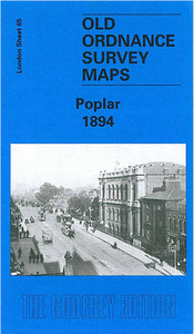
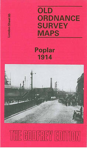
£12.99
This is a pop-up journey through animal habitats around the world by one of the world`s leading paper engineers. Travel around the world with Robert Crowther & discover fascinating facts about animals of all shapes & sizes! Children will love exploring the 3D animal habitats; they can peer between trees in the rainforest, peek into crevices in desert rocks, lift the flaps, pull the tabs & discover which animals live where. Packed with information & tiny details to spot, this is a book which will be enjoyed again & again. It is packed with fascinating facts about animals from all around the world. It features ingenious pop-up mechanisms from the master paper engineer. There are beautiful illustrations with lots of tiny details to spot. It is the perfect gift. ...
Archived Product
£8.99
Alice Butler has been receiving some odd messages
- all anonymous, all written in code. Are they from someone at Pop Co, the
...
Archived Product
£13.99
A 248-km long circular route across the foothils of the German Alps in the footsteps of Pope Benedict XVI, presented by the Verlag Esterbauer in guide with maps at 1:50, 000 showing the route & its variants. Extensive information is conveyed by symbols, indicating road surface, campsites & other accommodation, repair workshops, recreational facilities, places of interest, etc. A list of various types of accommodation facilities is included.IIMPORTANT
- PLEASE NOTE BEFORE ORDERING
- ALL THE TEXT IN THIS TITLE IS GERMAN ONLY. MAP LEGEND

Includes::
ENGLISH (please see our sample image) & the information provided on the maps is sufficient to use this title without any knowledge of German.ABOUT THE BIKELINE SERIES: all the titles have been meticulously researched & are highly regarded in their native Germany. Most titles, as indicated in their individual descriptions, also include a separate section listing selected accommodation, from hotels to campsites, youth hostels & rooms in private houses, all with addresses, telephone numbers & price range. Information on towns along each route

Includes::
a list of places of interest, with opening hours, etc. Several of the guides also have street plans. To see the list of other titles in the Bikeline series please click on the series link.


...
Archived Product
£9.99
Cardinal Jorge Bergoglio was chosen as the next Pope in one of the shortest conclaves in history. He is the first Pope Francis, the first Jesuit Pope, the first Pope to come from Latin America. Who is this man, & how did he come to such high position? This book begins with the arrival of Bergoglio`s family in Buenos Aires in 1929, travelling from Italy, explores his childhood as one of a family of five, his first job as a factory cleaner & the bout of pneumonia which forced him to reassess his life completely. Then from his early days as a seminarian through his experience as a teacher of psychology & literature, through to his consecration as a cardinal by Pope John Paul II, Bergoglio shares his experiences of faith & life. The difficult subjects are met head on, from the declining numbers of priests to celibacy & even the sex abuse scandals that have rocked the church
- & through it all, Bergoglio`s humble approach & desire to live an austere & faithful life shine through. This is a Pope who will not allow himself to be fitted to a traditional mould
- & the world waits with bated breath to see what his time as leader of the world`s largest church will bring.

...
Archived Product
£9.50
Poperinge
- Ieper, map No. 28/1-2 in the topographic survey of Belgium at 1:20, 000 covering the central part of the Ypres Salient
...
Archived Product
£3.50
Poplar in 1914 in a fascinating series of reproductions of old Ordnance Survey plans in the Alan Godfrey Editions, ideal for anyone interested in the history of their neighbourhood or family. Three versions cover the area stretching from Upper North Street at Poplar eastward to Rathbone Street at Canning Town, & from Empson Street & Bromley Gasworks southward to Poplar High Street & Blackwall station. The area covers much of Poplar & south Bromley west of the River Lea & part of Canning Town to the east. Features include the East India Dock, Bow Creek, Bromley Marsh, Thames Iron Works, a stretch of the North London Railway with Poplar station, Poplar Gas Works, GER Wharf, Thames Plate Glass Works, Victoria Dock Road, Limehouse Cut, East India Dock Road, West Marsh, tramways, Brunswick Road, a stretch of the GER Woolwich line, with Canning Town station, Poplar Workhouse, Glasshouse Wharf, etc. Each map

Includes::
an extract from street directories. About the Alan Godfrey Editions of the 25” OS Series: Selected towns in Great Britain & Ireland are covered by maps showing the extent of urban development in the last decades of the 19th & early 20th century. The plans have been taken from the Ordnance Survey mapping & reprinted at about 15 inches to one mile (1:4, 340). On the reverse most maps have historical notes & many also include extracts from contemporary directories. Most maps cover about one mile (1.6kms) north/south, one & a half miles (2.4kms) across; adjoining sheets can be combined to provide wider coverage.FOR MORE INFORMATION & A COMPLETE LIST OF ALL AVAILABLE TITLES PLEASE CLICK ON THE SERIES LINK.

...
Archived Product
£3.50
Poplar & Canning Town in 1867 in a fascinating series of reproductions of old Ordnance Survey plans in the Alan Godfrey Editions, ideal for anyone interested in the history of their neighbourhood or family. Three versions cover the area stretching from Upper North Street at Poplar eastward to Rathbone Street at Canning Town, & from Empson Street & Bromley Gasworks southward to Poplar High Street & Blackwall station. The area covers much of Poplar & south Bromley west of the River Lea & part of Canning Town to the east. Features include the East India Dock, Bow Creek, Bromley Marsh, Thames Iron Works, a stretch of the North London Railway with Poplar station, Poplar Gas Works, GER Wharf, Thames Plate Glass Works, Victoria Dock Road, Limehouse Cut, East India Dock Road, West Marsh, tramways, Brunswick Road, a stretch of the GER Woolwich line, with Canning Town station, Poplar Workhouse, Glasshouse Wharf, etc. Each map

Includes::
an extract from street directories. About the Alan Godfrey Editions of the 25” OS Series: Selected towns in Great Britain & Ireland are covered by maps showing the extent of urban development in the last decades of the 19th & early 20th century. The plans have been taken from the Ordnance Survey mapping & reprinted at about 15 inches to one mile (1:4, 340). On the reverse most maps have historical notes & many also include extracts from contemporary directories. Most maps cover about one mile (1.6kms) north/south, one & a half miles (2.4kms) across; adjoining sheets can be combined to provide wider coverage.FOR MORE INFORMATION & A COMPLETE LIST OF ALL AVAILABLE TITLES PLEASE CLICK ON THE SERIES LINK.

...
Archived Product
£9.50
Topographical survey of Belgium at 1:20, 000 from Nationaal Geografisch Instituut / Institut Géographique National, the country’s national survey organization. Each 20K map covers one quarter of the corresponding 1:50, 000 map (with adjustments in the border & coastal areas). The maps provide all the information expected of topographic mapping at this scale & in addition have an unusually large amount of vegetation and/or land use information (different types of woodlands, gardens, orchards, heath, etc). The maps have a 1-km UTM grid, with margin ticks for latitude & longitude at intervals of 1`. Map legend & a glossary of terms used on the maps include English. Stanfords keeps as regular stock 20K maps for the World War I battlefields around the Ypres, Messines & Passchendaele, & for the area of the Battle of Waterloo. The 1:20, 000 survey covers the whole of Belgium & maps for other regions can be supplied as special orders. To see the list of titles in this series please click on the series link.PLEASE NOTE: the Long-Distance Footpaths Map of Belgium at 1:300, 000 which shows the division of Belgium into the 50K survey sheets can also be used to see in more detail coverage by the 20K maps. ...
Archived Product
£25.00
The major art installation Blood Swept Lands & Seas of Red at the Tower of London marked one hundred years since the first full day of Britain`s involvement in the First World War. Created by artists Paul Cummins & Tom Piper, 888, 246 ceramic poppies progressively filled the Tower`s famous moat between 17 July & 11 November 2014. Each poppy represented a British military fatality during the war. The poppies encircled the iconic landmark, creating a spectacular display visible from all around the Tower, which attracted more than 5 million visitors. The scale of the installation was intended to reflect the magnitude of such an important centenary & create a powerful visual commemoration. Featuring forewords by Paul Cummins & Tom Piper & stunning photography of the installation, The Poppies: Blood Red Lands & Seas of Red is the only official publication to mark this landmark event. As thousands of the poppies used in the installation tour the country during the remainder of the First World War Centenary, this publication will undoubtedly prove popular with visitors to both the Tower & the new venues alike. ...
Archived Product
£12.99
A new picture-book classic celebrating the poppy`s history, from two legends of children`s literature. Michael Morpurgo & Michael Foreman have teamed up with the Royal British Legion to tell an original story that explains the meaning behind the poppy. In Flanders` fields, young Martens knows his family`s story, for it is as precious as the faded poem hanging in their home. From a poor girl comforting a grieving soldier, to an unexpected meeting of strangers, to a father`s tragic death many decades after treaties were signed, war has shaped Martens`s family in profound ways
- it is their history as much as any nation`s. They remember. They grieve. They honour the past. This book also

Includes::
a full-colour, illustrated afterword that explains the history that inspired the story.


...
Archived Product

Poplar 1894

Poplar in 1894 in a fascinating series of reproductions of old Ordnance Survey plans in the Alan Godfrey Editions, ideal for anyone interested in the history of their neighbourhood or family. Three versions cover the same area, stretching from Upper North Street at Poplar eastward to Rathbone Street at Canning Town, and from Empson Street and Bromley Gasworks southward to Poplar High Street and Blackwall station. The area covers much of Poplar and south Bromley west of the River Lea and part of Canning Town to the east. Features include the East India Dock, Bow Creek, Bromley Marsh, Thames Iron Works, a stretch of the North London Railway with Poplar station, Poplar Gas Works, GER Wharf, Thames Plate Glass Works, Victoria Dock Road, Limehouse Cut, East India Dock Road, West
Marsh, tramways, Brunswick Road, a stretch of the GER Woolwich line, with Canning Town station, Poplar Workhouse, Glasshouse Wharf, etc. Each map includes an extract from street directories.About the Alan Godfrey Editions of the 25” OS Series:Selected towns in Great Britain and Ireland are covered by maps showing the extent of urban development in the last decades of the 19th and early 20th century. The plans have been taken from the Ordnance Survey mapping and reprinted at about 15 inches to one mile (1:4, 340). On the reverse most maps have historical notes and many also include extracts from contemporary directories. Most maps cover about one mile (1.6kms) north/south, one and a half miles (2.4kms) across; adjoining sheets can be combined to provide wider coverage.FOR MORE
INFORMATION AND A COMPLETE LIST OF ALL AVAILABLE TITLES PLEASE CLICK ON THE SERIES LINK.
RIP - This product is no longer available on our network. It was last seen on 25.09.2019

This page now acts as a permanent archive for this product. Add more information using the comments box below to ensure it can still be found by future generations.

Use our search facility to see if it is available from an alternative contributor.
  • External links may include paid for promotion
  • Availability: Out Of Stock
  • Supplier: Stanfords
  • SKU: 9781841512426
Availability: In Stock
£3.50

Product Description

Poplar in 1894 in a fascinating series of reproductions of old Ordnance Survey plans in the Alan Godfrey Editions, ideal for anyone interested in the history of their neighbourhood or family. Three versions cover the same area, stretching from Upper North Street at Poplar eastward to Rathbone Street at Canning Town, & from Empson Street & Bromley Gasworks southward to Poplar High Street & Blackwall station. The area covers much of Poplar & south Bromley west of the River Lea & part of Canning Town to the east. Features include the East India Dock, Bow Creek, Bromley Marsh, Thames Iron Works, a stretch of the North London Railway with Poplar station, Poplar Gas Works, GER Wharf, Thames Plate Glass Works, Victoria Dock Road, Limehouse Cut, East India Dock Road, West Marsh, tramways, Brunswick Road, a stretch of the GER Woolwich line, with Canning Town station, Poplar Workhouse, Glasshouse Wharf, etc. Each map

Includes::
an extract from street directories. About the Alan Godfrey Editions of the 25” OS Series: Selected towns in Great Britain & Ireland are covered by maps showing the extent of urban development in the last decades of the 19th & early 20th century. The plans have been taken from the Ordnance Survey mapping & reprinted at about 15 inches to one mile (1:4, 340). On the reverse most maps have historical notes & many also include extracts from contemporary directories. Most maps cover about one mile (1.6kms) north/south, one & a half miles (2.4kms) across; adjoining sheets can be combined to provide wider coverage.FOR MORE INFORMATION & A COMPLETE LIST OF ALL AVAILABLE TITLES PLEASE CLICK ON THE SERIES LINK.

Reviews/Comments

Add New

Price History

Vouchers

No voucher codes found.
Do you know a voucher code for this product or supplier? Add it to Insights for others to use.

Facebook

Jargon Buster

Contemporary - Modern era design
India - A subcontinent in Asia
Contemporary - A design reference to indicate post war modern design
Glass - A solid, typically transparent. Brittle and used in windows. The first patent granted in the UK was for Glass.
Bow - A type of Knot used on cloting
Bow - A weapon used for firing arrows
iron - An electrical deviced used for removing creases from fabrics
iron - A chemical element (FE). The most common element on earth
History - Anything that happens in the past. An acedemic subject.
Road - a manmade lane or a path that is used to speed up travel.
Contemporary - An object that is living in the same time.
Ideal - Something that satisfies a perfect criteria.
Family - A group of people that live together made up from parents and children.

Supplier Information

Stanfords
Stanfords was established in 1853 and opened their iconic Covent Garden flagship store in 1901. They have become the top retailer of maps, travel books and accessories in the UK and arguably offer the largest selection of maps and travel books worldwide. Famous names such as Captain Robert Falcon Scott, Ranulph Fiennes and Michael Palin have purchased from Stanfords. They now have a shop in Bristol and both stores together with other venues operate a calendar of events including talks, book signings and exhibitions. As a specialist map retailer, the map selection is comprehensive and includes road maps, street maps and walking maps from worldwide destinations, as well as a selection of world atlases and wall maps. Books include travel guides and travel literature. Stanfords also stock globes, from miniatures made of blue marble to magnificent floor-standing globes. The website features a selection of interesting articles on travel topics.
Page Updated: 2023-11-12 20:15:36

Community Generated Product Tags

Oh No! The productWIKI community hasn't generated any tags for this product yet!
Menu