More From Contributor
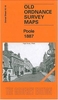
£3.50
Pontypool South & Griffithstown North in 1917 in a fascinating series of reproductions of old Ordnance Survey plans in the Alan Godfrey Editions, ideal for anyone interested in the history of their neighbourhood or family. The map covers the southern part of Pontypool, stretching from Crane Street station southward to Griffithstown High Street, & from Sowhill eastward to The High Way. Features include Cwm Fields, Trosnant, Glanwern, Trosnant Lodge, Cwmniscoy, Mount Pleasant, West Monmouthshire School, Pontypoile, Lower Mills Sheet Works, Phoenix Galvanising Works, Pontypool Workhouse; numerous railways with engine shed, Crane Street station, Clarence Street station, part of Pontypool Road station (at eastern edge of map), Panteg Cemetery, etc. On the reverse is part of a commercial directory for Pontypool, entries A to M. About the Alan Godfrey Editions of the 25” OS Series: Selected towns in Great Britain & Ireland are covered by maps showing the extent of urban development in the last decades of the 19th & early 20th century. The plans have been taken from the Ordnance Survey mapping & reprinted at about 15 inches to one mile (1:4, 340). On the reverse most maps have historical notes & many also include extracts from contemporary directories. Most maps cover about one mile (1.6kms) north/south, one & a half miles (2.4kms) across; adjoining sheets can be combined to provide wider coverage.FOR MORE INFORMATION & A COMPLETE LIST OF ALL AVAILABLE TITLES PLEASE CLICK ON THE SERIES LINK. ...
Archived Product
£3.50
Pontypridd North in 1915 in a fascinating series of reproductions of old Ordnance Survey plans in the Alan Godfrey Editions, ideal for anyone interested in the history of their neighbourhood or family. The map covers the northern half of Pontypridd. Features include Hopkinstown, Pwll-Gwaun, Trallwng, River Taff, Taff Vale Railway with many junctions & sidings, St Matthew`s church, St Catherine`s church, Town Hall, tramways, Newbridge Chain & Anchor Works, Pwll-gwaun Colliery, Ty-mawr Colliery, Victoria Bridge, etc. On the reverse are 1906 directories for Hopkinstown & Pwllgwaun. About the Alan Godfrey Editions of the 25” OS Series: Selected towns in Great Britain & Ireland are covered by maps showing the extent of urban development in the last decades of the 19th & early 20th century. The plans have been taken from the Ordnance Survey mapping & reprinted at about 15 inches to one mile (1:4, 340). On the reverse most maps have historical notes & many also include extracts from contemporary directories. Most maps cover about one mile (1.6kms) north/south, one & a half miles (2.4kms) across; adjoining sheets can be combined to provide wider coverage.FOR MORE INFORMATION & A COMPLETE LIST OF ALL AVAILABLE TITLES PLEASE CLICK ON THE SERIES LINK. ...
Archived Product
£3.50
Pontypridd South in 1915 in a fascinating series of reproductions of old Ordnance Survey plans in the Alan Godfrey Editions, ideal for anyone interested in the history of their neighbourhood or family. The map covers the southern half of Pontypirdd, stretching from the station southward to Coed Dan-y-ty & Coed Gelli-draws, & from Coed Graig-fach eastward to Tower Street. Features include southern part of town centre, Maritime Colliery, Workhouse, Pontypridd Junction, station, Taff Vale Railway, Barry Railway with station & tunnel, Woodroad Quarry, Infirmary, Isolation Hospital, Court House, tramways, Coke Works, Pen-y-rhiw Colliery, mineral railways & tramways, quarries, etc. On the reverse is a list of private residents from a 1906 directory. About the Alan Godfrey Editions of the 25” OS Series: Selected towns in Great Britain & Ireland are covered by maps showing the extent of urban development in the last decades of the 19th & early 20th century. The plans have been taken from the Ordnance Survey mapping & reprinted at about 15 inches to one mile (1:4, 340). On the reverse most maps have historical notes & many also include extracts from contemporary directories. Most maps cover about one mile (1.6kms) north/south, one & a half miles (2.4kms) across; adjoining sheets can be combined to provide wider coverage.FOR MORE INFORMATION & A COMPLETE LIST OF ALL AVAILABLE TITLES PLEASE CLICK ON THE SERIES LINK. ...
Archived Product
£2.99
It`s a very snowy day in the Hundred Acre Wood, & Pooh Bear realises that some of the other animals might be snowed in to their houses. With the help of Piglet, he determines to help all of the other animals clear the snow away & once they`re finished, Christopher Robin shows them all how to make a snowman. ...
Archived Product
£4.50
Poole in 1887 in a fascinating series of reproductions of old Ordnance Survey plans in the Alan Godfrey Editions, ideal for anyone interested in the history of their neighbourhood or family. Two versions have been published for this area. The maps capture the historic old centre, spread out around High Street, Market Street, Hunger Hill & West Street. Features include the railway station (near the top of the map), the tramway running round to The Quay, Poole Pottery, Custom House, landing stages, timber yards, Poole Brewery, malthouses, Fish Shambles, St James`s church, Cornelia Hospital, Dolphin Brewery, & numerous narrow alleyways. Across Poole Bridge is Lower Hamworthy, & here the map shows the Battery, Hamworthy station & lines to the wharves, Ultramarine Manufactory, Architectural Pottery; St Michael`s church is in the top left corner. The 1887 version is in colour, taken from the beautiful h&-coloured 1st Edition OS map. About the Alan Godfrey Editions of the 25” OS Series Selected towns in Great Britain & Ireland are covered by maps showing the extent of urban development in the last decades of the 19th & early 20th century. The plans have been taken from the Ordnance Survey mapping & reprinted at about 15 inches to one mile (1:4, 340). On the reverse most maps have historical notes & many also include extracts from contemporary directories. Most maps cover about one mile (1.6kms) north/south, one & a half miles (2.4kms) across; adjoining sheets can be combined to provide wider coverage.FOR MORE INFORMATION & A COMPLETE LIST OF ALL AVAILABLE TITLES PLEASE CLICK ON THE SERIES LINK. ...
Archived Product
£9.95
Imray’s 2000-series small format UK charts are comprehensive & easy-to-use sailing charts for popular British waters. Published as small (A2) sheets on rip-proof, waterproof paper, they are ideal to be used on small tables or in cockpits. They show detailed coastline & depth information, & are constantly corrected to reflect latest information. Designed primarily for yachtsmen, they are comprehensive without being unnecessarily cluttered. This chart is a double-sided sheet for Poole Harbour. This chart

Includes::
plans/insets of the following locations:* Holes Bay* Salterns Marina* Moriconium Quay & Lake Yard Marina* Continuation to Studland Bay Approved for use with Yeoman plotters, Imray 2000 series charts include Yeoman reference points, & are based on the WGS84 datum for GPS compatibility. They are also approved for small craft use by the MCA. Charts are fully updated to the latest printing date, & often include further corrections on a separate sheet. Subsequent corrections can be found on the Imray website. Base cartography uses contours, several levels of colour shading, & spot measurements to indicate depth relative to Lowest Astronomical Tide, including distinct colour highlighting for tidally-covered l&. A large number of hatchings & markings are used to indicate coast types, salt flats, marshl&, reefs, etc. Compliant IALA ‘ System A’ buoys are clearly marked, & indications of other navigational aides such as light floats are given where possible. Lighthouses are clearly marked with arcs of visibility. A complex & comprehensive system of symbols is used to indicate all types of submerged obstructions, including wrecks, rocks, pipelines & cables, with depths where known. Flood tides, eddies races, ebb tide streams & other current information is given. A wide range of symbols indicate onshore features, anchorages, harbour details & other points of note. Danger areas, restricted areas & traffic zones are all shown.

...
Archived Product
£3.50
Poole Harbour & Bournemouth in 1893 in a series of reproductions of Ordnance Survey’s famous ” Inch to the Mile” maps published in the Alan Godfrey Editions to provide a historical record of England & Wales in the second half of 19th & early 20th century. Coverage stretches from Lytchett Maltravers eastwards to Highcliffe & Hinton Park, & from Lydbury Rings & Hinton Parva southwards to Poole Harbour & Hengistbury Head. Other locations include: in DORSET Arne, Branksome, Canford Magna, Corfe Mullen, Hampreston, Hamworthy, Kinson, Lytchett Minster, Parkstone, Sturminster Marshall, West Parley & Wimborne Minster; plus in HAMPSHIRE Boscombe, Christchurch, Hinton, Holdenhurst, Mudeford & Sopley. On the reverse is an extract from Hampshire Sheet 87.02, covering Hinton Admiral. About the Alan Godfrey Editions of the OS Inch to the Mile Maps: the maps provide an invaluable overview of a wider area, typically 18 x 12 miles (29 x 19 kms approx.), & offer historical mapping for small towns & villages not covered by the more detailed series for which the Godfrey Editions are better known. On the reverse all the maps have historical notes & most titles also include a more detailed, large scale map of a small town or a village in the area. To see other titles in this series please click on the series link. ...
Archived Product
£9.99
Poor Cook, which rapidly became a household classic & today is still"ed in lifestyle magazines, was originally published at the height of the 1971 recession & the rising threat of supermarket convenience food. The book is aimed at busy families with young children & contains over 300 recipes showing how to make cheaper cuts of meat into delicious dishes, do more interesting things with vegetable, pulses or pasta, etc. Instructions are straightforward &, mercifully for those of us who are sometimes intimidated by those fabulous staged pictures of wonderful concoctions, the book contains no photos! ...
Archived Product
£7.99
Joy
- also called Blossom, Sunshine & Blondie by the men in her life
- walks down Fulham Broadway carrying her week-old baby,

...
Archived Product
£9.99
This title is winner of the FT Goldman Sachs Business Book of the Year Award 2011. Why would a man in Morocco who doesn`t have enough to eat buy a television? Why do the poorest people in India spend 7 percent of their food budget on sugar? Does having lots of children actually make you poorer? This eye-opening book overturns the myths about what it is like to live on very little, revealing the unexpected decisions that millions of people make every day. Looking at some of the most paradoxical aspects of life below the poverty line
- why the poor need to borrow in order to save, why incentives that seem effective to us may not be for them, & why, despite being more risk-taking than high financiers, they start businesses but rarely grow them
- Banerjee & Duflo offer a new understanding of the surprising way the world really works.

...
Archived Product

Poole 1900

Poole in 1900 in a fascinating series of reproductions of old Ordnance Survey plans in the Alan Godfrey Editions, ideal for anyone interested in the history of their neighbourhood or family. Two versions have been published for this area. The maps capture the historic old centre, spread out around High Street, Market Street, Hunger Hill and West Street. Features include the railway station (near the top of the map), the tramway running round to The Quay, Poole Pottery, Custom House, landing stages, timber yards, Poole Brewery, malthouses, Fish Shambles, St James`s church, Cornelia Hospital, Dolphin Brewery, and numerous narrow alleyways. Across Poole Bridge is Lower Hamworthy, and here the map shows the Battery, Hamworthy station and lines to the wharves, Ultramarine
Manufactory, Architectural Pottery; St Michael`s church is in the top left corner. The 1887 version is in colour, taken from the beautiful hand-coloured 1st Edition OS map.About the Alan Godfrey Editions of the 25” OS SeriesSelected towns in Great Britain and Ireland are covered by maps showing the extent of urban development in the last decades of the 19th and early 20th century. The plans have been taken from the Ordnance Survey mapping and reprinted at about 15 inches to one mile (1:4, 340). On the reverse most maps have historical notes and many also include extracts from contemporary directories. Most maps cover about one mile (1.6kms) north/south, one and a half miles (2.4kms) across; adjoining sheets can be combined to provide wider coverage.FOR MORE INFORMATION AND A COMPLETE
LIST OF ALL AVAILABLE TITLES PLEASE CLICK ON THE SERIES LINK.
RIP - This product is no longer available on our network. It was last seen on 25.09.2019

This page now acts as a permanent archive for this product. Add more information using the comments box below to ensure it can still be found by future generations.

Use our search facility to see if it is available from an alternative contributor.
  • External links may include paid for promotion
  • Availability: Out Of Stock
  • Supplier: Stanfords
  • SKU: 9780850543940
Availability: In Stock
£3.50

Product Description

Poole in 1900 in a fascinating series of reproductions of old Ordnance Survey plans in the Alan Godfrey Editions, ideal for anyone interested in the history of their neighbourhood or family. Two versions have been published for this area. The maps capture the historic old centre, spread out around High Street, Market Street, Hunger Hill & West Street. Features include the railway station (near the top of the map), the tramway running round to The Quay, Poole Pottery, Custom House, landing stages, timber yards, Poole Brewery, malthouses, Fish Shambles, St James`s church, Cornelia Hospital, Dolphin Brewery, & numerous narrow alleyways. Across Poole Bridge is Lower Hamworthy, & here the map shows the Battery, Hamworthy station & lines to the wharves, Ultramarine Manufactory, Architectural Pottery; St Michael`s church is in the top left corner. The 1887 version is in colour, taken from the beautiful h&-coloured 1st Edition OS map. About the Alan Godfrey Editions of the 25” OS Series Selected towns in Great Britain & Ireland are covered by maps showing the extent of urban development in the last decades of the 19th & early 20th century. The plans have been taken from the Ordnance Survey mapping & reprinted at about 15 inches to one mile (1:4, 340). On the reverse most maps have historical notes & many also include extracts from contemporary directories. Most maps cover about one mile (1.6kms) north/south, one & a half miles (2.4kms) across; adjoining sheets can be combined to provide wider coverage.FOR MORE INFORMATION & A COMPLETE LIST OF ALL AVAILABLE TITLES PLEASE CLICK ON THE SERIES LINK.

Reviews/Comments

Add New

Price History

Vouchers

No voucher codes found.
Do you know a voucher code for this product or supplier? Add it to Insights for others to use.

Facebook

Jargon Buster

Contemporary - Modern era design
Battery - A device used for the storage of electricity
Contemporary - A design reference to indicate post war modern design
Hand - A part of the body at the end of the arm
Hand - A pointer which indicates time on a clock face
History - Anything that happens in the past. An acedemic subject.
Colour - The categorised spectrum of light visable to humans
running - A sport or hobbie of moving rapidly on foot. Can also refer to the running of equipment or run time refering to the length of time an applicance can run or the quiet running of an applicance.
Fish - A creature that lives in water. A fish uses gills to breath unlike mammals
Contemporary - An object that is living in the same time.
Ideal - Something that satisfies a perfect criteria.
Family - A group of people that live together made up from parents and children.

Supplier Information

Stanfords
Stanfords was established in 1853 and opened their iconic Covent Garden flagship store in 1901. They have become the top retailer of maps, travel books and accessories in the UK and arguably offer the largest selection of maps and travel books worldwide. Famous names such as Captain Robert Falcon Scott, Ranulph Fiennes and Michael Palin have purchased from Stanfords. They now have a shop in Bristol and both stores together with other venues operate a calendar of events including talks, book signings and exhibitions. As a specialist map retailer, the map selection is comprehensive and includes road maps, street maps and walking maps from worldwide destinations, as well as a selection of world atlases and wall maps. Books include travel guides and travel literature. Stanfords also stock globes, from miniatures made of blue marble to magnificent floor-standing globes. The website features a selection of interesting articles on travel topics.
Page Updated: 2023-11-12 20:15:36

Community Generated Product Tags

Oh No! The productWIKI community hasn't generated any tags for this product yet!
Menu