More From Contributor

£6.99
How did Bear Grylls become one of the world`s toughest adventurers? This is the thrilling story of everyone`s favourite real-life action man
- from secret childhood missions to climb the town`s school buildings & steeples, to starring in his own global TV series & becoming Chief Scout to the Scouting Association. Known & admired by millions, Bear Grylls has survived in dangerous environments few would dare to visit. Find out what it`s like to take on mountaineering, martial arts, parachuting, life in the SAS
- & all that nature can throw at you! It is abridged for younger readers.

...
Archived Product
£7.99
Most people`s appetite for cake knows no bounds, so here to follow the successful title ` Cupcake Magic` comes a new volume devoted entirely to delicious muffins. All the cakes & muffins are made with free-range eggs & a donation from the sale of each book will be made to a battery hen rescue charity. The ultimate in convenience food, muffins are portable, freezable, quick to make & impossible to resist. A savoury muffin can be a complete meal-in-one, while a fruit-packed treat, warm from the oven, is the perfect snack. Packed with baking tips, captivating new recipes, modern photography & delightful illustrations, this book provides ideas for sweet & savoury, children`s & adult`s, seasonal & special occasion muffins. A section devoted to ingredients & equipment makes sure you`ve always got the right kit to h&. Filled with enthusiasm, humour & expert baking knowledge, fans of ` Cupcake Magic` will love this must-have follow-up. ...
Archived Product
£6.99
George bravely explores the museum to see, Who`s been stealing the cakes on the sly. It could be the mammoth
- or maybe the knight?
...
Archived Product
£7.99
Satisfy that chocolate craving as soon as it strikes with Mug Cakes: Chocolate
- over 30 recipes for quick & delicious chocolate
...
Archived Product
£6.95
Topographic coverage of mainland Spain at 1:50, 000 in the MTN50 (Mapa Topográfico Nacional) series from the Centro Nacional de Información Geografica, the country’s civilian survey organization. The maps have contours at 20m intervals, enhanced by relief shading, plus colouring and/or graphics to show different types of terrain, vegetation or land use. Boundaries of national parks & other protected areas are marked. In addition to all the usual information featured on topographic mapping at this scale, detailed presentation of the road & rail networks, rural tracks & paths, etc, the maps also show campsites & mountain refuges. On more recent editions some GRs, the official long-distance hiking routes, are also marked (although not as clearly as on hiking maps from other publishers). Each map covers 29.5x 18.5 km (with adjustments in the border or coastal areas). The maps have a 1-km UTM grid, plus margin ticks for latitude & longitude at 1` intervals. Map legend is in Spanish only.HOW TO CHOOSE THE RIGHT 50K MAP: all the titles in CNIG’s 200K Provincial Road Maps series at 1:200, 000 are overprinted with the grid for the 1:50, 000 maps & can be used to see the area covered by each 50K title. TO SEE THE LIST OF TITLES IN THIS SERIES PLEASE CLICK ON THE SERIES LINK.PLEASE NOTE
- MAP TITLES: the grids shown on our website serve both the civilian & the military 1:50, 000 topographic series. Although the areas covered by maps in both series are identical (apart from some border or coastal sheets), occasionally map titles differ – only one title is shown on the grid, usually the military one. In Galicia, the Basque country & in the Catalan speaking areas the tendency now is to use local place names rather than the often better known Castilian ones. Where possible, both versions are included in our titles. Map titles listed on our website are based on information received by us at the time of publication, but sometimes maps arrive showing a completely different title! As long as the map number is as ordered, the correct map has been supplied.
...
Archived Product
£11.99
ugello
- Val di Sieve
- Monte Falterona, map no. 30, in a series of walking maps covering the Ligurian Alps & the coast,

...
Archived Product
£12.99
This inspiring Harry Potter A5 notebook is perfect for lists, notes & magic spells! The design features the Hogwarts crest & the words ` Muggle Studies`, referring to an elective class at Hogwarts which taught students all about Muggles & their daily lives, amongst an intricate design. It benefits from a hardback cover with debossed detailing & soft touch lamination finish, a golden snitch in a repeated print on the first inside pages, 240 ruled 80gsm cream pages with corner Harry Potter logo detail, a page marker ribbon & elastic b&. The attractive design makes this a standout product for any Harry Potter fan. ...
Archived Product
£7.95
The Mughal Empire dominated India for three centuries. Under enlightened patrons such as Akbar the Great in the 16th century & Shah Jahan in the 17th century, this vast Muslim empire, which ranged from Kashmir & Afghanistan to the Deccan at its height, produced paintings & architecture of exceptional quality, such as the Taj Mahal. Using architectural drawings, miniatures, paintings & memoirs written by the rulers themselves, this book reveals the achievements of this great empire. ...
Archived Product
£11.50
Mühldorf a. Inn in a series of GPS compatible recreational editions of the Bavarian topographic survey at 1:25, 000, with waymarked hiking trails & cycling routes, campsites & youth hostels, etc. Coverage

Includes::
Ampfing, Töging a. Inn, Tüßling, Waldkraiburg, Kraiburg a. Inn, Polling. Contours used in this map vary between 5 to 20m according to the terrain, with 20m interval predominantly used for hilly areas. Varied colouring show different types of landscape: woods, vineyards, fields etc. Maps in this series feature extensive overprint highlighting local & long-distance footpaths & cycle routes, including King Ludwig Way or different variants of the Way of St James, indicating their waymarking. Symbols highlight different types of accommodation (campsites, youth hostels, refuges, etc), sport & recreational facilities, various places of interest, etc. The maps have a 1-km UTM grid. Map legend & all the text are in German only. To see other titles in this series please click on the series link.

...
Archived Product
£9.99
Growing up in Rhodesia in the 1960s, Peter Godwin inhabited a magical & frightening world of leopard-hunting, lepers, witch doctors, snakes & forest fires. As an adolescent, he became a conscript caught in the middle of a vicious civil war, & then as an adult who returned to Zimbabwe as a journalist to cover the bloody transition to majority rule, he discovered a land stalked by death & danger. An incredibly insightful memoir wrote through with nostalgic lament, “ Mukiwa” shows Peter Godwin both exhilarated & exhausted by the love of a country that he once fought for & for the war that he eventually lost. ...
Archived Product

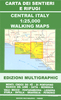
Mugello - Alto Mugello 25K Ed. Multigraphic Map No. 28

Mugello - Alto Mugello, map no. 28, in a series of walking maps covering the Ligurian Alps and the coast, the crest of the Apennines along the border of Tuscany with its neighbouring regions, and parts of Tuscany itself. Most maps have contours at 25-metre intervals, with colouring for forests and some relief shading. The cartography is rather old fashioned and sometimes not as clear as in other map series but for many areas, especially for parts of Tuscany, these are the only hiking maps available.An overprint highlights hiking paths, including all the popular long-distance routes such as Garfagnana Trekking, Alta Via dei Monti Liguri and the GEA, Grande Escursione Appenninica, the main path over the crests of the Apennines. The overprint also shows campsites and, where
appropriate, mountain refuges and other types of alpine accommodation. Most of the maps are double-sided, as indicated by the map number. Each map covers approximately 26 x 17km / 16 x 11 miles per side. Some of the maps indicate latitude and longitude at the map corners, but with longitude sometimes based on Rome rather than Greenwich. Map legends vary, most maps include English. *In this title:* contours are at 25m intervals. Interesting location as prominently highlighted. The map has no geographical coordinates. Map legend includes English.
RIP - This product is no longer available on our network. It was last seen on 25.09.2019

This page now acts as a permanent archive for this product. Add more information using the comments box below to ensure it can still be found by future generations.

Use our search facility to see if it is available from an alternative contributor.
  • Availability: Out Of Stock
  • Supplier: Stanfords
  • SKU: X175600
Availability: In Stock
£11.99

Product Description

Mugello
- Alto Mugello, map no. 28, in a series of walking maps covering the Ligurian Alps & the coast, the crest of the Apennines along the border of Tuscany with its neighbouring regions, & parts of Tuscany itself. Most maps have contours at 25-metre intervals, with colouring for forests & some relief shading. The cartography is rather old fashioned & sometimes not as clear as in other map series but for many areas, especially for parts of Tuscany, these are the only hiking maps available. An overprint highlights hiking paths, including all the popular long-distance routes such as Garfagnana Trekking, Alta Via dei Monti Liguri & the GEA, Grande Escursione Appenninica, the main path over the crests of the Apennines. The overprint also shows campsites &, where appropriate, mountain refuges & other types of alpine accommodation. Most of the maps are double-sided, as indicated by the map number. Each map covers Approx. 26 x 17km / 16 x 11 miles per side. Some of the maps indicate latitude & longitude at the map corners, but with longitude sometimes based on Rome rather than Greenwich. Map legends vary, most maps include English. * In this title:* contours are at 25m intervals. Interesting location as prominently highlighted. The map has no geographical coordinates. Map legend

Includes::
English.

Reviews/Comments

Add New

Intelligent Comparison

Oooops!
We couldn't find anything!
Perhaps this product's unique.... Or perhaps we are still looking for comparisons!
Click to bump this page and we'll hurry up.

Price History

Vouchers

No voucher codes found.
Do you know a voucher code for this product or supplier? Add it to Insights for others to use.

Facebook

Jargon Buster

Hiking - An outdoor activity envolving walking in nature
Metre - 100cm. A unit of length.
Greenwich - A southern borough in London.
Accommodation - A room in which someone can live in, for example in a hotel
Popular - Something that is admired and liked by many people.

Supplier Information

Stanfords
Stanfords was established in 1853 and opened their iconic Covent Garden flagship store in 1901. They have become the top retailer of maps, travel books and accessories in the UK and arguably offer the largest selection of maps and travel books worldwide. Famous names such as Captain Robert Falcon Scott, Ranulph Fiennes and Michael Palin have purchased from Stanfords. They now have a shop in Bristol and both stores together with other venues operate a calendar of events including talks, book signings and exhibitions. As a specialist map retailer, the map selection is comprehensive and includes road maps, street maps and walking maps from worldwide destinations, as well as a selection of world atlases and wall maps. Books include travel guides and travel literature. Stanfords also stock globes, from miniatures made of blue marble to magnificent floor-standing globes. The website features a selection of interesting articles on travel topics.
Page Updated: 2023-11-12 20:15:36

Community Generated Product Tags

Oh No! The productWIKI community hasn't generated any tags for this product yet!
Menu