
 United Kingdom
 France
 Germany
 Netherlands
 Sweden
 USA
USA
 Italy
Italy
 Spain
Spain
More From Contributor


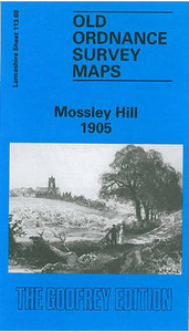
Mossley Hill 1905
Mossley Hill in 1905 in a fascinating series of reproductions of old Ordnance Survey plans in the Alan Godfrey Editions, ideal for anyone interested in the history of their neighbourhood or family. The map covers much of the Mossley Hill area south-eastern Liverpool, including portions of Aigburth, Garston and Allerton. Coverage stretches from St Anne`s Road eastward to Allerton Road, and from Palmerston Road southward to Aigburth Hall Road. Features include Holmfield, Garston Old Vicarage, LNWR railway with Mossley Hill station, St Anne`s Crescent, Carnatic Hall, Elmwood Hall Laundry, streets being developed around station, Forty Pits, West Farm, Maryton Grange, Drygrange, etc; east of the railway the land is largely rural with some villas around Allerton Road. On the
reverse are street directory entries for Allerton Road, Elmswood Road, Greenhill Road and Mossley Hill Road. About the Alan Godfrey Editions of the 25” OS Series:Selected towns in Great Britain and Ireland are covered by maps showing the extent of urban development in the last decades of the 19th and early 20th century. The plans have been taken from the Ordnance Survey mapping and reprinted at about 15 inches to one mile (1:4, 340). On the reverse most maps have historical notes and many also include extracts from contemporary directories. Most maps cover about one mile (1.6kms) north/south, one and a half miles (2.4kms) across; adjoining sheets can be combined to provide wider coverage.FOR MORE INFORMATION AND A COMPLETE LIST OF ALL AVAILABLE TITLES PLEASE CLICK ON THE SERIES LINK.
reverse are street directory entries for Allerton Road, Elmswood Road, Greenhill Road and Mossley Hill Road. About the Alan Godfrey Editions of the 25” OS Series:Selected towns in Great Britain and Ireland are covered by maps showing the extent of urban development in the last decades of the 19th and early 20th century. The plans have been taken from the Ordnance Survey mapping and reprinted at about 15 inches to one mile (1:4, 340). On the reverse most maps have historical notes and many also include extracts from contemporary directories. Most maps cover about one mile (1.6kms) north/south, one and a half miles (2.4kms) across; adjoining sheets can be combined to provide wider coverage.FOR MORE INFORMATION AND A COMPLETE LIST OF ALL AVAILABLE TITLES PLEASE CLICK ON THE SERIES LINK.

Product Description
Reviews/Comments
Add New
Intelligent Comparison
Archived Product

Worsley Hall 1904 Stanfords
£2.95
Archived Product

Worsley Hall 1904 Stanfords
£3.50
Archived Product

Muswell Hill 1935 Stanfords
£3.50
Vouchers
No voucher codes found.
Do you know a voucher code for this product or supplier? Add it to Insights for others to use.
Do you know a voucher code for this product or supplier? Add it to Insights for others to use.
 Denmark