
 United Kingdom
 France
 Germany
 Netherlands
 Sweden
 USA
USA
 Italy
Italy
 Spain
Spain
More From Contributor


Manhattan Borch
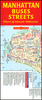
Excellent laminated and waterproof tourist plan for visitors to New York City, combining a plan of the whole of Manhattan with enlargements for the Midtown and Financial District. On one side is the main part of Manhattan, stretching north beyond Harlem to Hamilton Heights, with the rest of borough on the reverse at the same scale of 1:15, 000. The adjoining areas of Brooklyn, Queens and Bronx are included. The plan indicates various places of interest, highlighting the city’s top 30 sights, selected hotels, subway stations with line numbers, railway, bus and ferry terminals, one way streets, etc. The plan also shows names of individual neighbourhoods (Greenwich Village, SoHo, Upper West Side, etc.)On the reverse, the Midtown area is shown in greater detail at 10, 000,
extending from the East River to the Ninth Avenue and from the southern end of the Central Park to Empire State Building and Madison Square Garden (31st St.) Many individual buildings, famous shops, hotels and theatres in the Broadway/Times Square area are named. A similar enlargement is provided for the Financial District at southern tip of Manhattan, including the World Trade Center Memorial Site. All the plans are indexed, with lists of streets, neighbourhoods, parks, hotels, public buildings, main sights and places of interest. Also includes in a diagram of the whole of the NYC subway network, a zip-code map of Manhattan, a small map of USA showing the states and time zones, and information on the city’s climate.
extending from the East River to the Ninth Avenue and from the southern end of the Central Park to Empire State Building and Madison Square Garden (31st St.) Many individual buildings, famous shops, hotels and theatres in the Broadway/Times Square area are named. A similar enlargement is provided for the Financial District at southern tip of Manhattan, including the World Trade Center Memorial Site. All the plans are indexed, with lists of streets, neighbourhoods, parks, hotels, public buildings, main sights and places of interest. Also includes in a diagram of the whole of the NYC subway network, a zip-code map of Manhattan, a small map of USA showing the states and time zones, and information on the city’s climate.

Product Description
Reviews/Comments
Add New
Intelligent Comparison
Archived Product

Manhattan Beach Stanfords
£8.99
Archived Product

Manhattan Nocturne Stanfords
£7.99
Archived Product

Manhattan `45 Stanfords
£9.99
Archived Product

Yucatan Borch Stanfords
£9.99
Vouchers
No voucher codes found.
Do you know a voucher code for this product or supplier? Add it to Insights for others to use.
Do you know a voucher code for this product or supplier? Add it to Insights for others to use.
 Denmark