
 United Kingdom
 France
 Germany
 Netherlands
 Sweden
 USA
USA
 Italy
Italy
 Spain
Spain
More From Contributor


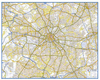
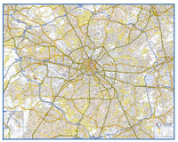
Manchester Premier Map
Manchester Premier Street Plan from Geographers' A-Z Map Company designed to cover the city within its administrative boundaries, with a separate comprehensive index booklet listing streets, places and areas, industrial estates, selected flats and walkways, service areas, stations, and selected places of interest, shown where appropriate with their postcodes.The city is covered at 3.4 inches to 1 mile (1:18, 635). Coverage includes: Ashton-under-Lyne, Denton, Eccles, Kearsley, Oldham, Prestwich, Sale, Salford and Stockport. An inset shows road access to the Manchester International Airport. Current edition of this title was published in 2010. The inside of the map cover has an enlargement presenting the town centre in greater clarity at 5
Product Description
Reviews/Comments
Add New
Intelligent Comparison
Archived Product

Manchester Premier A-Z Map Stanfords
£6.95
Archived Product
Leicester Premier Map Stanfords
£5.50
Archived Product
Manchester Pocket Map Stanfords
£1.50
Archived Product

Manchester Premier A-Z Map WATERPROOF Stanfords
£13.99
Archived Product
Manchester Premier A-Z Wall Map PAPER Stanfords
£6.99
Archived Product
Manchester Z-Map Stanfords
£1.99
Archived Product
Leeds Premier Map Stanfords
£5.95
Archived Product
Manchester Premier Wall Map ENCAPSULATED Stanfords
£24.99
Vouchers
No voucher codes found.
Do you know a voucher code for this product or supplier? Add it to Insights for others to use.
Do you know a voucher code for this product or supplier? Add it to Insights for others to use.
 Denmark