More From Contributor
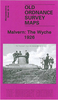
£8.99
Malvern Hills, Bredon Hill, Tewkesbury, Ledbury, Pershore & Upton upon Severn area on a detailed topographic & GPS compatible map No. 190, paper version, from the Ordnance Survey’s 1:25, 000 Explorer series. MOBILE DOWNLOADS: this title & all the other OS Explorer maps include a code for downloading after purchase the digital version onto your smartphone or tablet for viewing on the OS smartphone app.OS EXPLORER SERIES: to see the list of all the titles in the OS Explorer series, both paper & waterproof versions, please click on the series link. The Explorer series, Ordnance Survey’s most detailed maps recommended for anyone enjoying outdoor activities, provides topographic coverage of Great Britain at 1:25, 000 on GPS compatible maps with hiking trails, cycling routes & extensive tourist information. Each printed map is available either on paper or as a waterproof & tear-resistant OS Active Map, as indicated in its title. Britain’s National Parks & other areas of particular tourist interest are presented on often double-sided OL (Outdoor Leisure) maps, whilst most standard format Explorers cover an area of 30 x 20km (approx. 19 x 12 miles). All three versions (paper, waterproof & digital) are the same & provide plenty of recreational & tourist information, indicating the traditional public right of way paths (except in Scotland where different laws apply), including bridleways & byways. National Trails & other long-distance paths are marked, as well as permissive footpaths or bridleways & on-road or traffic-free cycle routes with, where appropriate, their National/ Regional Cycle Network numbers. Boundaries of access land are clearly marked. A wide range of symbols provides additional tourist information, highlighting camping & caravanning sites, information offices & visitors’ centres, parking & picnicking places, country pubs, sport & recreational facilities including cycle hire locations & mountain biking trails, historic buildings & museums, etc. Exceptionally clear presentation of the landscape is provided by contours at 5m or in the uplands at 10m intervals, with additional spot heights plus colouring and/or graphics for different types of woodlands, orchards, heath, marshl&, scree or boulders, & other topographic features. For GPS users the maps have British National Grid lines at 1km intervals, with latitude & longitude given by margin ticks at 1`. Clearly laid out map legend

Includes::
French & German translations for the tourist information symbols.

...
Archived Product
£6.39
A detailed topographic map of Malvern Hills & Bredon Hill from the Ordnance Survey Explorer series, covering Tewkesbury, Ledbury, Pershore & Upton upon Severn. Edition A3; Publication date November 2008 About this series: These highly detailed maps show all the administrative boundaries, settlements as small as isolated farms, the road network down to unfenced roads & country tracks, & field boundaries (hedges & drystone walls) which make navigation across the countryside much easier. Steep gradients on roads are indicated. Various landmarks, e.g. powerlines, archaeological sites, windmills, churches & lighthouses are shown & additional graphics indicate natural terrain features such as cliffs, scree, mud & vegetation variations. The contour interval is 5 metres in the lower parts of the country & 10 metres in the uplands, & spot heights are marked. Each map covers an area of 30 x 20km (i.e. approx. 19 x 12 miles), with some double-sided maps covering more, as indicated in the individual descriptions. The maps are fully GPS compatible, with the National Grid shown at 1km intervals & latitude & longitude indicated by margin ticks at 1'. The Explorer series has replaced the earlier, green-cover Pathfinder maps. The Explorer series is now complete & covers all of Engl&, Wales & Scotl&. Some sheets for popular areas like the National Parks are still branded as Outdoor Leisure (OL) maps, but are now included in this series as the cartography is the same as that in the Explorer Maps. The Explorer maps offer a substantial improvement on the Pathfinder series, with greater use of colour, larger area per map, & stronger emphasis on information for ramblers & tourists. This series is ideal for walking & other outdoor pursuits & each map shows a large amount of information for ramblers & tourists. Public rights of way are shown (except in Scotland), together with other routes with public access: National Trails & Recreational Paths, permitted paths & bridleways, & selected cycle routes. Open access land created under the Countryside & Rights of Way Act 2000 is marked. Tourist information

Includes::
caravan & camp sites, Park & Ride locations, recreation/leisure/sport centres, museums, historic buildings, English Heritage & National Trust sites, rural pubs, etc. The map legend is in English only, except for the tourist information content which is also in French & German.

...
Archived Product
£11.19
Laminated waterproof edition of a detailed topographic map of Malvern Hills & Bredon Hill from the Ordnance Survey Explorer series, covering Tewkesbury, Ledbury, Pershore & Upton upon Severn. Edition A3; Publication date November 2008 About this series: These highly detailed maps show all the administrative boundaries, settlements as small as isolated farms, the road network down to unfenced roads & country tracks, & field boundaries (hedges & drystone walls) which make navigation across the countryside much easier. Steep gradients on roads are indicated. Various landmarks, e.g. powerlines, archaeological sites, windmills, churches & lighthouses are shown & additional graphics indicate natural terrain features such as cliffs, scree, mud & vegetation variations. The contour interval is 5 metres in the lower parts of the country & 10 metres in the uplands, & spot heights are marked. Each map covers an area of 30 x 20km (i.e. approx. 19 x 12 miles), with some double-sided maps covering more, as indicated in the individual descriptions. The maps are fully GPS compatible, with the National Grid shown at 1km intervals & latitude & longitude indicated by margin ticks at 1'. The Explorer series has replaced the earlier, green-cover Pathfinder maps. The Explorer series is now complete & covers all of Engl&, Wales & Scotl&. Some sheets for popular areas like the National Parks are still branded as Outdoor Leisure (OL) maps, but are now included in this series as the cartography is the same as that in the Explorer Maps. The Explorer maps offer a substantial improvement on the Pathfinder series, with greater use of colour, larger area per map, & stronger emphasis on information for ramblers & tourists. This series is ideal for walking & other outdoor pursuits & each map shows a large amount of information for ramblers & tourists. Public rights of way are shown (except in Scotland), together with other routes with public access: National Trails & Recreational Paths, permitted paths & bridleways, & selected cycle routes. Open access land created under the Countryside & Rights of Way Act 2000 is marked. Tourist information

Includes::
caravan & camp sites, Park & Ride locations, recreation/leisure/sport centres, museums, historic buildings, English Heritage & National Trust sites, rural pubs, etc. The map legend is in English only, except for the tourist information content which is also in French & German.

...
Archived Product
£3.95
The Wells of Malvern map published by Harvey Map Services in cooperation with the Malvern Spa Association to show the locations of nine of the Malvern Hill’s spring water features, each with a photo & a brief description. The sites, accessible by car or with a short walk from local roads, are marked on a detailed topographic map of the hills, with contours at 10m intervals & colouring to indicate different types of land use. Symbols show car parks, campsites & youth hostels, public toilets, etc. The map has British national grid lines. Current edition of this title was published in 2002. ...
Archived Product
£3.50
Malvern Link in 1926 in a fascinating series of reproductions of old Ordnance Survey plans in the Alan Godfrey Editions, ideal for anyone interested in the history of their neighbourhood or family. The map covers most of Malvern Link, extending from Albert Park Road northward & eastward to St Leonard`s church, Newl&. Features include railway with station, Upper Howsell, Quest Hills, St Cuthbert`s school, saw mill, laundry, Link Farm, motor works, St Matthias church, Worcester Road area, St Leonards & convent, Beauchamp Almshouses, Newl&, The Grange, St Leonard`s church, etc. On the reverse is a selection of street directory entries, including Church Road, Howsell Road, Pickersleigh Road, Richmond Road & Worcester Road. About the Alan Godfrey Editions of the 25” OS Series: Selected towns in Great Britain & Ireland are covered by maps showing the extent of urban development in the last decades of the 19th & early 20th century. The plans have been taken from the Ordnance Survey mapping & reprinted at about 15 inches to one mile (1:4, 340). On the reverse most maps have historical notes & many also include extracts from contemporary directories. Most maps cover about one mile (1.6kms) north/south, one & a half miles (2.4kms) across; adjoining sheets can be combined to provide wider coverage.FOR MORE INFORMATION & A COMPLETE LIST OF ALL AVAILABLE TITLES PLEASE CLICK ON THE SERIES LINK. ...
Archived Product
£3.50
Malvern Wells in 1903 in a fascinating series of reproductions of old Ordnance Survey plans in the Alan Godfrey Editions, ideal for anyone interested in the history of their neighbourhood or family. The map is double-sided; the main map covers the area from the Wyche Cutting southward to Green Lane, & from Hanley Road westward across the Hills to Colwall station. Features include (on the Malvern side) St Peter`s church, Hornyold Arms Hotel, Holy Well, The Wells House, The Cottage, Essington Hotel, Hornyold Wood, Wood Farm, etc. A good section of the Malvern Hills is shown & across it (on the Herefordshire side) are Broadfields, Linden, Knell New House, Upper Wyche, Knell Farm, Winnings Farm, Redland Lodge, Colwall Stone, railway with Colwall station & both entrances to tunnel shown, Vinegar Works, New Court, The Gables, part of race course, etc. On the reverse is part of the adjacent sheet 46.08 extending coverage south to include St Wulstan`s RC Chapel in Little Malvern, Graham House & The Abbey. About the Alan Godfrey Editions of the 25” OS Series: Selected towns in Great Britain & Ireland are covered by maps showing the extent of urban development in the last decades of the 19th & early 20th century. The plans have been taken from the Ordnance Survey mapping & reprinted at about 15 inches to one mile (1:4, 340). On the reverse most maps have historical notes & many also include extracts from contemporary directories. Most maps cover about one mile (1.6kms) north/south, one & a half miles (2.4kms) across; adjoining sheets can be combined to provide wider coverage.FOR MORE INFORMATION & A COMPLETE LIST OF ALL AVAILABLE TITLES PLEASE CLICK ON THE SERIES LINK. ...
Archived Product
£3.50
Malvern: The Wyche in 1926 in a fascinating series of reproductions of old Ordnance Survey plans in the Alan Godfrey Editions, ideal for anyone interested in the history of their neighbourhood or family. The map covers part of Great Malvern with the northern tip of Malvern Wells. Coverage runs from the Worcestershire Beacon southward to Upper Wyche. Herefordshire area is left blank. Features include Lower Wyche & Upper Wyche, All Saints church, Railway Inn, quarries, gold mine, Royal Well Mineral Water Works, Worcestershire Beacon, Firs Valley, Malvern Common, The Firs, Emmanuel Church, Hampton House, Mathon Lodge, etc. About the Alan Godfrey Editions of the 25” OS Series: Selected towns in Great Britain & Ireland are covered by maps showing the extent of urban development in the last decades of the 19th & early 20th century. The plans have been taken from the Ordnance Survey mapping & reprinted at about 15 inches to one mile (1:4, 340). On the reverse most maps have historical notes & many also include extracts from contemporary directories. Most maps cover about one mile (1.6kms) north/south, one & a half miles (2.4kms) across; adjoining sheets can be combined to provide wider coverage.FOR MORE INFORMATION & A COMPLETE LIST OF ALL AVAILABLE TITLES PLEASE CLICK ON THE SERIES LINK. ...
Archived Product
£16.99
Driven by her family`s devastating losses, Congolese expatriate Francisca Thelin embarks, with human rights activist Lisa J. Shannon, on a perilous journey back to her beloved homel&, now under the shadow of one of Africa`s most feared militias--Joseph Kony`s Lord`s Resistance Army. With gunmen camped at the edge of town, Francisca is forced to face a paralyzing clash between her life in America & her family`s rapidly evaporating world--and the reality that their rush to her family`s aid may backfire. Mama Koko & the Hundred Gunmen weaves Francisca`s journey with stories of the family`s harrowing encounters with gunmen & tales from their past to create a vivid, illuminating portrait of a place & its people. We hear of Mama Koko`s early life as a gap-toothed beauty plotting to escape her inevitable fate of wife & motherhood; of Papa Alexander`s empire of wives, each of whom he married because she cooked & cleaned & made good coffee; & of Francisca`s idyllic childhood, when she ran barefoot through the family`s coffee plantation gorging herself on mangoes & fish that ”were the size of small children.” Offering compelling testimony to the strength of the human spirit & the beauty of human connection in the darkest of times, Mama Koko & the Hundred Gunmen also explores what it means & requires to truly make a difference in an unjust & often violent world. ...
Archived Product
£12.99
Topographic survey of France at 1:25, 000 in IGN`s excellent TOP25 / Série Bleue series. All the maps are GPS compatible, with a 1km UTM grid plus latitude & longitude lines at 5’ intervals. Contours are at 5m intervals except for mountainous areas where the maps have contours at 10m intervals, vividly enhanced by hill shading & graphics for rocky terrain. Colouring with graphics indicates different types of vegetation or land use (deciduous or coniferous forests, moors, orchards, vineyards, etc). PLEASE NOTE: coverage of France at this scale is currently being revised – the format & the presentation of each title are indicated by the letters at the end of its Sheet Reference number (e.g. 0416ET, 3531ETR, 1923SB, etc.)MAPS WITH FULL TOURIST OVERPRINT & AN ENGLISH MAP LEGEND: all TOP25 maps & the SB editions of Série Bleue have an overprint highlighting waymarked walking trails including long-distance GR routes &, where appropriate, ski routes. Symbols indicate campsites, gîtes d’etape, refuges, equestrian centres & other recreational facilities or sites, tourist information centres, cultural heritage, etc. Towns & locations of particular interest are highlighted.- ET or OT = single-sided TOP25 map covering approx. 29x 21 km / 18x 13 miles.- ETR or OTR = waterproof & tear resistant TOP25 map covering the same area as the corresponding ET or OT number, but double-sided, printed on a smaller size sheet with a good overlap between the sides.- SB = Série Bleue map with full tourist overprint; these maps, first introduced in summer 2014, each cover approx. 29x 24km / 18x 15 miles.SÉRIE BLEUE maps with numbers ending in E (Est) or O (Ouest): most editions now indicate the GR routes, but do not show any other tourist information. Map legend is in French only. Each map covers approx. 14x 20km / 9x 12 miles. ...
Archived Product
£14.95
What is it in the operatic Italian psyche that allows-indeed, forgives, even applauds-Italy`s premier for conducting a lifestyle as decadent as a Fellini extravaganza, while organizing an ongoing string of questionable behaviors & politically incorrect gaffes not seen since the days of Nero? All this, & yet Mr. Berlusconi remains completely ”understood” by so many of his countrymen-some of whom keep coming back for more! Best-selling writer Beppe Severgnini, who by explaining America to Italians humorously immortalized American behavior in his book ” Ciao, America!, ” now trains his sights on his own countrymen. Through witty yet substantive anecdotes touching on Italy`s current political & economic climate, Severgnini decodes the Italian premier`s style & appeal, exploring his rise to power & creating a compulsively readable portrait of Italy today. ...
Archived Product

Malvern Wells 1903

Malvern Wells in 1903 in a fascinating series of reproductions of old Ordnance Survey plans in the Alan Godfrey Editions, ideal for anyone interested in the history of their neighbourhood or family. Selected towns in Great Britain and Ireland are covered by maps showing the extent of urban development in the last decades of the 19th and early 20th century.In this title: the map is double-sided. The main map covers the area from the Wyche Cutting southward to Green Lane, and from Hanley Road westward across the Hills to Colwall station. Features include (on the Malvern side) St Peter's church, Hornyold Arms Hotel, Holy Well, The Wells House, The Cottage, Essington Hotel, Hornyold Wood, Wood Farm, etc. A good section of the Malvern Hills is shown and across it (on the Herefordshire
side) are Broadfields, Linden, Knell New House, Upper Wyche, Knell Farm, Winnings Farm, Redland Lodge, Colwall Stone, railway with Colwall station and both entrances to tunnel shown, Vinegar Works, New Court, The Gables, part of race course. On the reverse is part of the adjacent sheet 46.08 extending coverage south to include St Wulstan's RC Chapel in Little Malvern, Graham House, The Abbey, etc. About the Alan Godfrey Editions of the 25
RIP - This product is no longer available on our network. It was last seen on 25.09.2019

This page now acts as a permanent archive for this product. Add more information using the comments box below to ensure it can still be found by future generations.

Use our search facility to see if it is available from an alternative contributor.
  • External links may include paid for promotion
  • Availability: Out Of Stock
  • Supplier: Stanfords
  • SKU: XL44915
Availability: In Stock
£2.95

Product Description

Malvern Wells in 1903 in a fascinating series of reproductions of old Ordnance Survey plans in the Alan Godfrey Editions, ideal for anyone interested in the history of their neighbourhood or family. Selected towns in Great Britain & Ireland are covered by maps showing the extent of urban development in the last decades of the 19th & early 20th century. In this title: the map is double-sided. The main map covers the area from the Wyche Cutting southward to Green Lane, & from Hanley Road westward across the Hills to Colwall station. Features include (on the Malvern side) St Peter's church, Hornyold Arms Hotel, Holy Well, The Wells House, The Cottage, Essington Hotel, Hornyold Wood, Wood Farm, etc. A good section of the Malvern Hills is shown & across it (on the Herefordshire side) are Broadfields, Linden, Knell New House, Upper Wyche, Knell Farm, Winnings Farm, Redland Lodge, Colwall Stone, railway with Colwall station & both entrances to tunnel shown, Vinegar Works, New Court, The Gables, part of race course. On the reverse is part of the adjacent sheet 46.08 extending coverage south to include St Wulstan's RC Chapel in Little Malvern, Graham House, The Abbey, etc. About the Alan Godfrey Editions of the 25

Reviews/Comments

Add New

Intelligent Comparison

Oooops!
We couldn't find anything!
Perhaps this product's unique.... Or perhaps we are still looking for comparisons!
Click to bump this page and we'll hurry up.

Price History

Vouchers

No voucher codes found.
Do you know a voucher code for this product or supplier? Add it to Insights for others to use.

Facebook

Jargon Buster

Hotel - An establishment which provides lodging for a fee
History - Anything that happens in the past. An acedemic subject.
Wood - A hard material found in trees. Used for tool making, fuel and construction.
Stone - Or Rock is a naturally occuring mineral categorised into three types, Igneous, Sedimentary and Metamorphic
cutting - The seperation of an object usually using a cutting tool such as a knife
Tunnel - a tunnel travels through an abject connecting one place to another.
Road - a manmade lane or a path that is used to speed up travel.
Cottage - A house typically found in the country, commonly small in size.
Ideal - Something that satisfies a perfect criteria.
Family - A group of people that live together made up from parents and children.

Supplier Information

Stanfords
Stanfords was established in 1853 and opened their iconic Covent Garden flagship store in 1901. They have become the top retailer of maps, travel books and accessories in the UK and arguably offer the largest selection of maps and travel books worldwide. Famous names such as Captain Robert Falcon Scott, Ranulph Fiennes and Michael Palin have purchased from Stanfords. They now have a shop in Bristol and both stores together with other venues operate a calendar of events including talks, book signings and exhibitions. As a specialist map retailer, the map selection is comprehensive and includes road maps, street maps and walking maps from worldwide destinations, as well as a selection of world atlases and wall maps. Books include travel guides and travel literature. Stanfords also stock globes, from miniatures made of blue marble to magnificent floor-standing globes. The website features a selection of interesting articles on travel topics.
Page Updated: 2023-11-12 20:15:36

Community Generated Product Tags

"hornyold wood" (2 people tagged the product this way)
Menu