More From Contributor
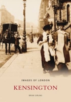
£34.95
Conceived as a retrospective, this book illustrates Kenro Izus refined artistic research & the work that for over thirty years he has been carrying out, like a tireless pilgrim, in the worlds most evocative holy sites: from the Egyptian pyramids & the ancient stones of Stonehenge to the site of Angkor Wat in Cambodia, from Buddhist temples in India & Indonesia to the Syrian desert & Tibetan peaks. Fascinated by the sublime beauty of ancient remains, he returns to the styles & printing techniques of 19th-century photography as best able to capture the mystical atmosphere of the places examined. ...
Archived Product
£3.50
Kensal Green in 1935 in a fascinating series of reproductions of old Ordnance Survey plans in the Alan Godfrey Editions, ideal for anyone interested in the history of their neighbourhood or family. Four versions of this map have been published, with Kensal Green on the west side of the map, west Kilburn to the east, & Kensal New Town near the foot of the map. Stretches of the Hampstead Junction, LNWR & GWR railway lines & the Grand Junction Canal run through the map. On the 1865 version there is little development apart from Kensal New Town, buildings along Kensal Road, part of Westbourne Green in the extreme Ssouth-eastern corner, & early west Kilburn streets around Canterbury Road. Near the centre of the map is Chamberlain Wood Farm. Each map shows All Souls (or Kensal Green) Cemetery. The later maps are much more built up, with solid streets of housing between Kensal New Town & the LNWR railway, including Harrow Road, Kilburn Lane, Shirland Road & many more. Other features include gasworks, carriage sheds, Queen`s Park, Queen`s Park station. On the 1913 map Kensal Rise, north of the LNWR is also built up. The 1935 map

Includes::
the car factory for Talbot cars. The three later maps include extracts from street directories. The 1865 map

Includes::
a description of the cemetery from Walford`s Old & New London. About the Alan Godfrey Editions of the 25” OS Series: Selected towns in Great Britain & Ireland are covered by maps showing the extent of urban development in the last decades of the 19th & early 20th century. The plans have been taken from the Ordnance Survey mapping & reprinted at about 15 inches to one mile (1:4, 340). On the reverse most maps have historical notes & many also include extracts from contemporary directories. Most maps cover about one mile (1.6kms) north/south, one & a half miles (2.4kms) across; adjoining sheets can be combined to provide wider coverage.FOR MORE INFORMATION & A COMPLETE LIST OF ALL AVAILABLE TITLES PLEASE CLICK ON THE SERIES LINK.


...
Archived Product
£3.50
Kensal Green & Queen`s Park in 1894 in a fascinating series of reproductions of old Ordnance Survey plans in the Alan Godfrey Editions, ideal for anyone interested in the history of their neighbourhood or family. Four versions of this map have been published, with Kensal Green on the west side, west Kilburn to the east, & Kensal New Town near the foot of the map. Stretches of the Hampstead Junction, LNWR & GWR railway lines & the Grand Junction Canal run through the map. On the 1865 version there is little development apart from Kensal New Town, buildings along Kensal Road, part of Westbourne Green in the extreme south-eastern corner, & early west Kilburn streets around Canterbury Road. Near the centre of the map is Chamberlain Wood Farm. Each map shows All Souls (or Kensal Green) Cemetery. The later maps are much more built up, with solid streets of housing between Kensal New Town & the LNWR railway, including Harrow Road, Kilburn Lane, Shirland Road & many more. Other features include gasworks, carriage sheds, Queen`s Park, Queen`s Park station. On the 1913 map Kensal Rise, north of the LNWR is also built up. The 1935 map

Includes::
the car factory for Talbot cars. The three later maps include extracts from street directories. The 1865 map

Includes::
a description of the cemetery from Walford`s Old & New London. About the Alan Godfrey Editions of the 25” OS Series: Selected towns in Great Britain & Ireland are covered by maps showing the extent of urban development in the last decades of the 19th & early 20th century. The plans have been taken from the Ordnance Survey mapping & reprinted at about 15 inches to one mile (1:4, 340). On the reverse most maps have historical notes & many also include extracts from contemporary directories. Most maps cover about one mile (1.6kms) north/south, one & a half miles (2.4kms) across; adjoining sheets can be combined to provide wider coverage.FOR MORE INFORMATION & A COMPLETE LIST OF ALL AVAILABLE TITLES PLEASE CLICK ON THE SERIES LINK.


...
Archived Product
£3.50
Kensal Green & Queen`s Park in 1913 in a fascinating series of reproductions of old Ordnance Survey plans in the Alan Godfrey Editions, ideal for anyone interested in the history of their neighbourhood or family. Four versions of this map have been published, with Kensal Green on the west side of the map, west Kilburn to the east, & Kensal New Town near the foot of the map. Stretches of the Hampstead Junction, LNWR & GWR railway lines & the Grand Junction Canal run through the map. On the 1865 version there is little development apart from Kensal New Town, buildings along Kensal Road, part of Westbourne Green in the extreme south-eastern corner, & early west Kilburn streets around Canterbury Road. Near the centre of the map is Chamberlain Wood Farm. Each map shows All Souls (or Kensal Green) Cemetery. The later maps are much more built up, with solid streets of housing between Kensal New Town & the LNWR railway, including Harrow Road, Kilburn Lane, Shirland Road & many more. Other features include gasworks, carriage sheds, Queen`s Park, Queen`s Park station. On the 1913 map Kensal Rise, north of the LNWR is also built up. The 1935 map

Includes::
the car factory for Talbot cars. The three later maps include extracts from street directories. The 1865 map

Includes::
a description of the cemetery from Walford`s Old & New London.* About the Alan Godfrey Editions of the 25” OS Series: Selected towns in Great Britain & Ireland are covered by maps showing the extent of urban development in the last decades of the 19th & early 20th century. The plans have been taken from the Ordnance Survey mapping & reprinted at about 15 inches to one mile (1:4, 340). On the reverse most maps have historical notes & many also include extracts from contemporary directories. Most maps cover about one mile (1.6kms) north/south, one & a half miles (2.4kms) across; adjoining sheets can be combined to provide wider coverage.FOR MORE INFORMATION & A COMPLETE LIST OF ALL AVAILABLE TITLES PLEASE CLICK ON THE SERIES LINK.


...
Archived Product
£3.50
Kensal Green & West Kilburn in 1865 in a fascinating series of reproductions of old Ordnance Survey plans in the Alan Godfrey Editions, ideal for anyone interested in the history of their neighbourhood or family. Four versions of this map have been published, with Kensal Green on the west side, west Kilburn to the east, & Kensal New Town near the foot of the map. Stretches of the Hampstead Junction, LNWR & GWR railway lines & the Grand Junction Canal run through the map. On the 1865 version there is little development apart from Kensal New Town, buildings along Kensal Road, part of Westbourne Green in the extreme south-eastern corner, & early west Kilburn streets around Canterbury Road. Near the centre of the map is Chamberlain Wood Farm. Each map shows All Souls (or Kensal Green) Cemetery. The later maps are much more built up, with solid streets of housing between Kensal New Town & the LNWR railway, including Harrow Road, Kilburn Lane, Shirland Road & many more. Other features include gasworks, carriage sheds, Queen`s Park, Queen`s Park station. On the 1913 map Kensal Rise, north of the LNWR is also built up. The 1935 map

Includes::
the car factory for Talbot cars. The three later maps include extracts from street directories. The 1865 map

Includes::
a description of the cemetery from Walford`s Old & New London. About the Alan Godfrey Editions of the 25” OS Series: Selected towns in Great Britain & Ireland are covered by maps showing the extent of urban development in the last decades of the 19th & early 20th century. The plans have been taken from the Ordnance Survey mapping & reprinted at about 15 inches to one mile (1:4, 340). On the reverse most maps have historical notes & many also include extracts from contemporary directories. Most maps cover about one mile (1.6kms) north/south, one & a half miles (2.4kms) across; adjoining sheets can be combined to provide wider coverage.FOR MORE INFORMATION & A COMPLETE LIST OF ALL AVAILABLE TITLES PLEASE CLICK ON THE SERIES LINK.


...
Archived Product
£12.99
This fascinating selection of historic photographs documents the dramatic transformation that has taken place over the last 150 years in the Royal Borough of Kensington & Chelsea. The book gives an unforgettable impression of familiar streets & districts as they developed, & it offers an insight into the lives & living conditions of the residents in the last years of Queen Victoria`s reign & in the early years of the twentieth century. The pictures tell the story of how a cluster of nineteenth-century villages became one of the best-known & most populous areas of London. The Royal Borough has since been noted as a centre of arts, commerce & fashion, as the scene of many historic occasions & as the home of famous personalities from public life. But the book also preserves the memory of ordinary people
- passengers crowded into a horse-drawn bus, road sweepers standing with their brooms, a schoolgirl crossing the street carrying a violin case, a baker`s boy pulling a handcart. This charming collection of historic photographs will add to the knowledge, appreciation & enjoyment of anyone who takes an interest in this part of London.
...
Archived Product
£7.99
This is not a guidebook. This little book brings together past & present to offer a taste of Kensington & Chelsea. Learn about the movers & shakers who shaped this fantastic royal borough. The great & the good; the bad & the ugly. Small wonders, tall stories, TRIUMPH & tragedy. Best places
- worst places. Local lingo, architecture, green spaces, events, traditions, fact, fiction. Origins, evolution, future. Written by a local who knows what makes KENSINGTON & CHELSEA tick.
...
Archived Product
£3.50
Kensington in 1871 in a fascinating series of reproductions of old Ordnance Survey plans in the Alan Godfrey Editions, ideal for anyone interested in the history of their neighbourhood or family. Three versions cover this area, stretching from Hornton Street to Cadogan Square, from Kensington Palace southward to Harrington Road. The Royal Albert Hall is in the centre of the map & other major features include The Serpentine, Natural History Museum, Brompton Road, Imperial Institute, Cromwell Road, Hyde Park Barracks, South Kensington, Gloucester Road & Kensington High St stations; Victoria & Albert Museum; St Margaret & St John`s Workhouse; Royal Horticultural Gardens (on 1871 map), Kensington Gardens, Kensington Palace, Knightsbridge, etc. About the Alan Godfrey Editions of the 25” OS Series: Selected towns in Great Britain & Ireland are covered by maps showing the extent of urban development in the last decades of the 19th & early 20th century. The plans have been taken from the Ordnance Survey mapping & reprinted at about 15 inches to one mile (1:4, 340). On the reverse most maps have historical notes & many also include extracts from contemporary directories. Most maps cover about one mile (1.6kms) north/south, one & a half miles (2.4kms) across; adjoining sheets can be combined to provide wider coverage.FOR MORE INFORMATION & A COMPLETE LIST OF ALL AVAILABLE TITLES PLEASE CLICK ON THE SERIES LINK. ...
Archived Product
£3.50
Kensington in 1894 in a fascinating series of reproductions of old Ordnance Survey plans in the Alan Godfrey Editions, ideal for anyone interested in the history of their neighbourhood or family. Three versions cover the area stretching from Hornton Street to Cadogan Square, from Kensington Palace southward to Harrington Road. The Royal Albert Hall is in the centre of the map & other major features include The Serpentine, Natural History Museum, Brompton Road, Imperial Institute, Cromwell Road, Hyde Park Barracks; South Kensington, Gloucester Road & Kensington High St stations; Victoria & Albert Museum; St Margaret & St John`s Workhouse; Royal Horticultural Gardens (on 1871 map), Kensington Gardens, Kensington Palace, Knightsbridge, etc. About the Alan Godfrey Editions of the 25” OS Series: Selected towns in Great Britain & Ireland are covered by maps showing the extent of urban development in the last decades of the 19th & early 20th century. The plans have been taken from the Ordnance Survey mapping & reprinted at about 15 inches to one mile (1:4, 340). On the reverse most maps have historical notes & many also include extracts from contemporary directories. Most maps cover about one mile (1.6kms) north/south, one & a half miles (2.4kms) across; adjoining sheets can be combined to provide wider coverage.FOR MORE INFORMATION & A COMPLETE LIST OF ALL AVAILABLE TITLES PLEASE CLICK ON THE SERIES LINK. ...
Archived Product
£3.50
Kensington in 1914 in a fascinating series of reproductions of old Ordnance Survey plans in the Alan Godfrey Editions, ideal for anyone interested in the history of their neighbourhood or family. Three versions cover the same area, stretching from Hornton Street to Cadogan Square, from Kensington Palace southward to Harrington Road. The Royal Albert Hall is in the centre of the map & other major features include The Serpentine, Natural History Museum, Brompton Road, Imperial Institute, Cromwell Road, Hyde Park Barracks; South Kensington, Gloucester Road & Kensington High St stations; Victoria & Albert Museum; St Margaret & St John`s Workhouse; Royal Horticultural Gardens (on 1871 map), Kensington Gardens, Kensington Palace, Knightsbridge. About the Alan Godfrey Editions of the 25” OS Series: Selected towns in Great Britain & Ireland are covered by maps showing the extent of urban development in the last decades of the 19th & early 20th century. The plans have been taken from the Ordnance Survey mapping & reprinted at about 15 inches to one mile (1:4, 340). On the reverse most maps have historical notes & many also include extracts from contemporary directories. Most maps cover about one mile (1.6kms) north/south, one & a half miles (2.4kms) across; adjoining sheets can be combined to provide wider coverage.FOR MORE INFORMATION & A COMPLETE LIST OF ALL AVAILABLE TITLES PLEASE CLICK ON THE SERIES LINK. ...
Archived Product

Kensington

This fascinating selection of over 200 old photographs of the Royal Borough of Kensington shows a surprisingly varied range of activities and views from this unique area of London over a period of one hundred years. Included in this volume are photographs of Edwardian scenes in Kensington Gardens, early underground trains, famous department stores in their founding years and a host of characters recorded as they shop, relax in the parks or listen to itinerant musicians playing in the streets. The camera also recorded streets and buildings that were lost during slim clearence programmes or new road schemes which can be seen again here. There are scenes of Kensington`s world famous museums and Earls Court and its exhibition grounds. Some references to property prices of around eighty
years ago make astonishing reading today! Most of the images collected here are published for the first time and have been drawn from the author`s own extensive collection of old picture postcards.
RIP - This product is no longer available on our network. It was last seen on 25.09.2019

This page now acts as a permanent archive for this product. Add more information using the comments box below to ensure it can still be found by future generations.

Use our search facility to see if it is available from an alternative contributor.
  • External links may include paid for promotion
  • Availability: Out Of Stock
  • Supplier: Stanfords
  • SKU: 9780752403694
Availability: In Stock
£12.99

Product Description

This fascinating selection of over 200 old photographs of the Royal Borough of Kensington shows a surprisingly varied range of activities & views from this unique area of London over a period of one hundred years. Included in this volume are photographs of Edwardian scenes in Kensington Gardens, early underground trains, famous department stores in their founding years & a host of characters recorded as they shop, relax in the parks or listen to itinerant musicians playing in the streets. The camera also recorded streets & buildings that were lost during slim clearence programmes or new road schemes which can be seen again here. There are scenes of Kensington`s world famous museums & Earls Court & its exhibition grounds. Some references to property prices of around eighty years ago make astonishing reading today! Most of the images collected here are published for the first time & have been drawn from the author`s own extensive collection of old picture postcards.

Reviews/Comments

Add New

Intelligent Comparison

Oooops!
We couldn't find anything!
Perhaps this product's unique.... Or perhaps we are still looking for comparisons!
Click to bump this page and we'll hurry up.

Price History

Vouchers

No voucher codes found.
Do you know a voucher code for this product or supplier? Add it to Insights for others to use.

Facebook

Jargon Buster

Camera - An electronic device used for taking photographs
World - A physical grouping, commonly used to describe earth and everything associated with ti
Road - a manmade lane or a path that is used to speed up travel.

Supplier Information

Stanfords
Stanfords was established in 1853 and opened their iconic Covent Garden flagship store in 1901. They have become the top retailer of maps, travel books and accessories in the UK and arguably offer the largest selection of maps and travel books worldwide. Famous names such as Captain Robert Falcon Scott, Ranulph Fiennes and Michael Palin have purchased from Stanfords. They now have a shop in Bristol and both stores together with other venues operate a calendar of events including talks, book signings and exhibitions. As a specialist map retailer, the map selection is comprehensive and includes road maps, street maps and walking maps from worldwide destinations, as well as a selection of world atlases and wall maps. Books include travel guides and travel literature. Stanfords also stock globes, from miniatures made of blue marble to magnificent floor-standing globes. The website features a selection of interesting articles on travel topics.
Page Updated: 2023-11-12 20:15:36

Community Generated Product Tags

Oh No! The productWIKI community hasn't generated any tags for this product yet!
Menu